A very active storm system is moving into the area starting with a series of cold fronts tonight (Saturday) that will begin to drop temperature significantly overnight and into Sunday. Highs for many areas along the Palmer Divide will be in the 20’s for Sunday. Quite the change from today’s 60’s and 70’s!
There have been a few forecast changes relating to timing, strongest intensity/impacts to the storm and snowfall amounts.
Here’s where we stand as of this evening…
Watches/Warnings/Advisories
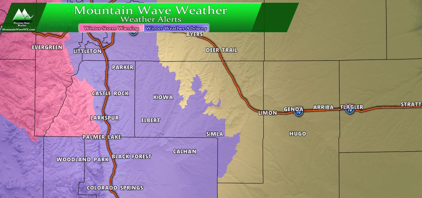
Winter Weather Highlights for the Palmer Divide/ S. Denver area as of 7PM this evening (10/26/2019)
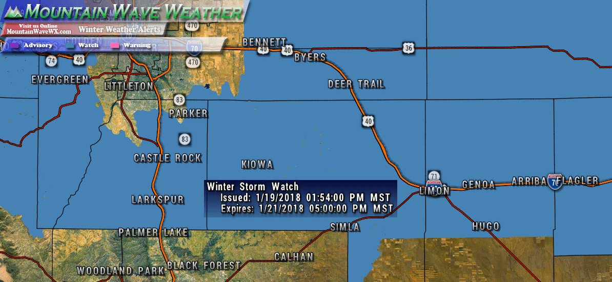
***Winter Weather Advisory***
In effect from 12PM Sunday Oct 27 – 6PM Monday Oct 28
Boulder and the western suburbs of Denver-Denver-Castle Rock-
Including the cities of Arvada, Boulder, Golden, Lakewood,
Longmont, Aurora, Brighton, City of Denver,
Denver International Airport, Highlands Ranch, Littleton, Parker,
Castle Rock, Elbert, Fondis, Kiowa, and Larkspur
154 PM MDT Sat Oct 26 2019

...WINTER WEATHER ADVISORY IN EFFECT FROM NOON SUNDAY TO 6 PM MDT
MONDAY...

* WHAT...Snow expected. Total snow accumulations of 5 to 10
  inches.

* WHERE...Boulder and the western suburbs of Denver, Denver and
  Castle Rock.

* WHEN...Light freezing drizzle is expected for a few hours Sunday
  morning. After that, it will snow the rest of Sunday through
  Monday. The main accumulation will be Sunday night.

* IMPACTS...Travel could be difficult at times. The worst
  conditions are expected Sunday night into Monday morning.
***Winter Storm Warning***
In effect from 3AM Sunday Oct 27 – 6PM Monday Oct 28
The Winter Storm outline area for the Palmer Divide is mainly in the foothills of Western Douglas County. There are additional Winter Storm Warnings for mountain locations
The Southern Front Range Foothills-
Including the cities of Bailey, Central City, Evergreen,
Georgetown, Idaho Springs, and Westcreek
154 PM MDT Sat Oct 26 2019

...WINTER STORM WARNING IN EFFECT FROM 3 AM SUNDAY TO 6 PM MDT
MONDAY...

* WHAT...Freezing drizzle followed by heavy snow. After a light
  glaze of ice, total snow accumulations will be 8 to 14 inches.

* WHERE...The Southern Front Range Foothills.

* WHEN...Freezing drizzle is expected early Sunday morning, then
  snow Sunday through Monday. The heaviest snow will be Sunday
  night.

* IMPACTS...Travel will be very difficult at time, with the worst
  conditions Sunday night into Monday morning.
Forecast/Hazards/Timelines/Impacts (The Need to Know Planning Stuff!)
Impacts
Snowfall/Travel Impacts
- It appears there will be minor impacts Sunday morning and through the day Sunday. Biggest concern is icy roads from freezing rain, slick spots will be possible. We are not expecting anything beyond minor impacts due to snow earlier in the day Sunday
- Moderate to high impacts to travel look most likely into Sunday night, early Monday morning and through the morning commute Monday morning.
- Roads are expected to become icy and snow packed in the heaviest areas of snow. Be prepared for difficult travel conditions along the front range including Denver, Palmer Divide and areas North of Denver
- Mountain areas will see potentially dangerous travel conditions late in the day Sunday and overnight into Monday. Please take this into account if you have mountain travel planned.
Timing
- Sunday
- Freezing rain will be possible into Sunday Morning, especially North of Denver
- Snow will be likely throughout the day but accumulations look light Sunday morning and early Sunday afternoon along the front range
- Snow will become heavy later in the day Sunday into the evening and overnight hours
- Very cold temperatures in the 20’s and teens are likely later on Sunday
- Monday
- Heavy snow overnight and cold temperatures means the commute Monday will see moderate to high impacts
- Snow is expected to continue through the day Monday with the heaviest accumulations in the morning.
- There is potential for snow later in the day but accumulations look likght
- Temperatures will struggle to reach the 30’s for most areas on Monday. Extreme cold is likely later Monday and into Monday night.
- Tuesday
- Uncertainty is high at this time but there is potential for the second storm to impact the area on Tuesday and Wednesday
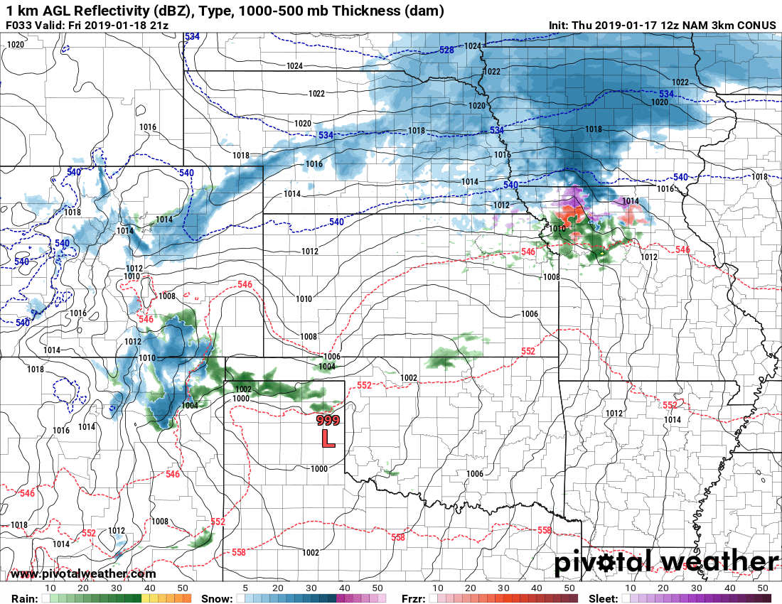
Snowfall
WPC product is uploaded below, this tends to over-do snow just a bit but given the cold nature of this storm and the higher snow accumulation potential and liquid/snow ratios being in the 15:1 range or even better, this seems accurate.
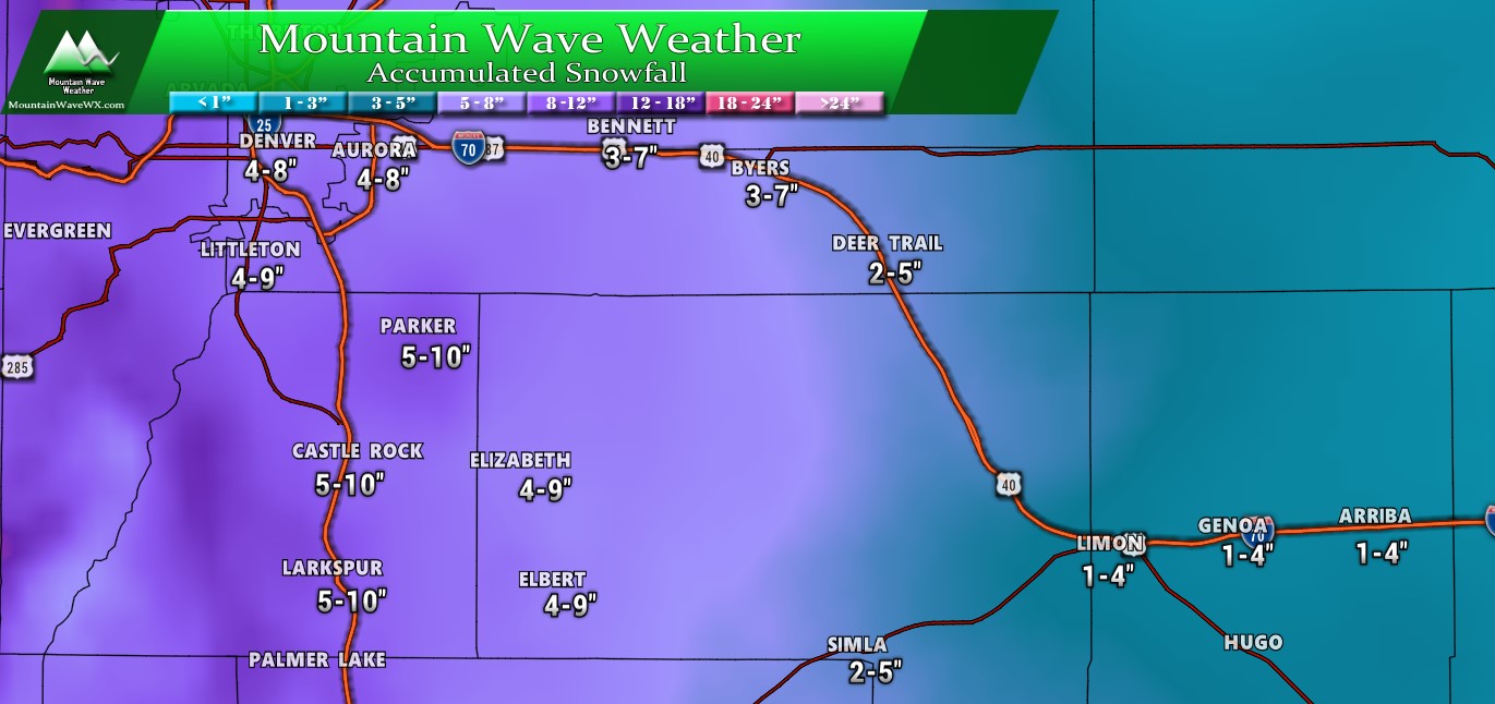
MMWAVWX forecast snowfall accumulation ranges for the Palmer Divide and South Denver as of 7PM 10/26/2019
Please note: there are some spotty areas (especially along and West of I-25) that could bust high on this range. Some areas may see up to or slightly more than a foot. Those areas will be spotty, for the most part locations should end up in these ranges.
Livestream Tonight
I will be doing another livestream tonight so make sure to tune in. I’ll zoom in on more areas for snowfall forecasts and take a look at what the models are saying along with answering any questions.
Tune in at 10PM tonight! You can catch it on my Facebook Page, it will pop up as soon as I go on!
Summary
This storm has been keeping a lot of meteorologists on their toes, with the shifting models, storm track, timing and impacts it’s been a fun one to watch!
I would not be surprised to see another curve ball or two as we get in the late forecast hours of this event. As always I’ll be sure to post any updates as needed!
Regarding the next storm; that moves in sometime during the Tuesday – Wednesday timeframe and so far it’s looking interesting. Let’s get through a good chunk of this one then I’ll switch gears to that one!

Thanks John, appreciate the time and energy and expertise you bring to giving us an in-depth forecast.
Thanks again John from Parker, CO.
Any snow total predictions for the Henderson/ Commerce City area?