As we move into April and experience warm sunny days, it’s easy to forget that April is our second snowiest month of the year. In an “average” April we would expect to see 9.2 inches of snow in Castle Rock. So far for the month of April Castle Rock is sitting at a whopping 0.0 inches of snowfall recorded.
So believe me when I say that seeing a large snow storm in April is not at all unusual!
First thing’s first, we have to get through the blast of warmth on Tuesday and gusty winds that will create high wildfire potential. Yes folks, despite a relatively wet late winter, we can still see fires especially when things get warm and windy and our vegetation is still mostly dormant.
Current Weather Watches and Warnings

Red Flag Warning for high fire danger is in effect for Tuesday 4/9/2019
You’ll hear us and other meteorologists use the term “fire and ice” a lot around this time of year. Mainly because it’s not unusual to have extremely warm and dry conditions precede a large spring snow storm. Here’s the details on this warning for the Palmer Divide region:
The National Weather Service in Denver has issued a Red Flag
Warning FOR WIND AND LOW RELATIVE HUMIDITY, which is in effect
from noon to 8 PM MDT Tuesday. The Fire Weather Watch is no
longer in effect.

* Affected Area...Fire Weather Zones 241...245...246...247 and
  249.

* Winds...South 10 to 20 mph with gusts up to 30 mph.

* Timing...south to southwesterly winds will increase and become
  gusty during the afternoon on Tuesday. Record to near record
  temperatures in the lower 80s combined with low humidity
  levels below 15 percent after 12 pm.

* Relative Humidity...As low as 13 percent.

* Impacts...New fire growth may start and spread rapidly and
  result in dangerous fire behavior.

PRECAUTIONARY/PREPAREDNESS ACTIONS...

A Red Flag Warning means that critical fire weather conditions
are either occurring....or expected to shortly. A combination of
strong winds...low relative humidity...and warm temperatures can
contribute to extreme fire behavior.
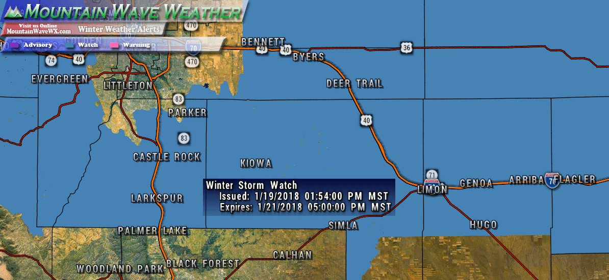
And just in as I was writing this article… a Winter Storm Watch has been issued…
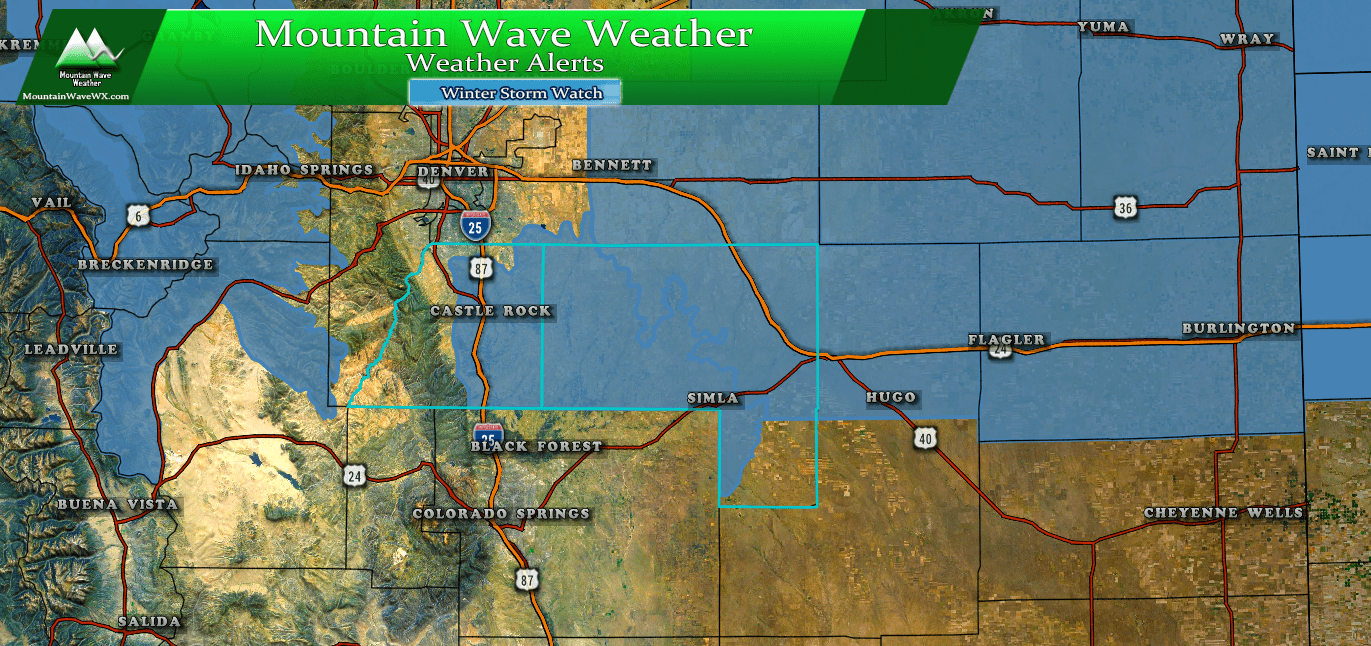
Winter Storm Watch was just issued at 3:15PM
Including the cities of Castle Rock, Elbert, Fondis, Kiowa,
Larkspur, Briggsdale, Grover, Pawnee Buttes, Raymer, Stoneham,
Brush, Fort Morgan, Goodrich, Wiggins, Bennett, Byers,
Deer Trail, Leader, Agate, Hugo, Limon, Matheson, Crook, Merino,
Sterling, Peetz, Akron, Cope, Last Chance, Otis, Julesburg, Ovid,
Sedgwick, Amherst, Haxtun, and Holyoke
310 PM MDT Mon Apr 8 2019

...WINTER STORM WATCH IN EFFECT FROM WEDNESDAY AFTERNOON THROUGH
THURSDAY MORNING...

* WHAT...Heavy snow possible. Total snow accumulations of 4 to 7
  inches. Winds could gust as high as 65 mph.

* WHERE...Portions of east central and northeast Colorado.

* WHEN...From Wednesday afternoon through Thursday morning.

* ADDITIONAL DETAILS...Travel could be very difficult. Blowing
  snow could significantly reduce visibility. Hazardous conditions
  will impact the evening commute on Wednesday and the morning
  travel Thursday. Strong winds could cause tree damage.

PRECAUTIONARY/PREPAREDNESS ACTIONS...

A Winter Storm Watch means there is potential for significant
snow, sleet or ice accumulations that may impact travel. Continue
to monitor the latest forecasts.
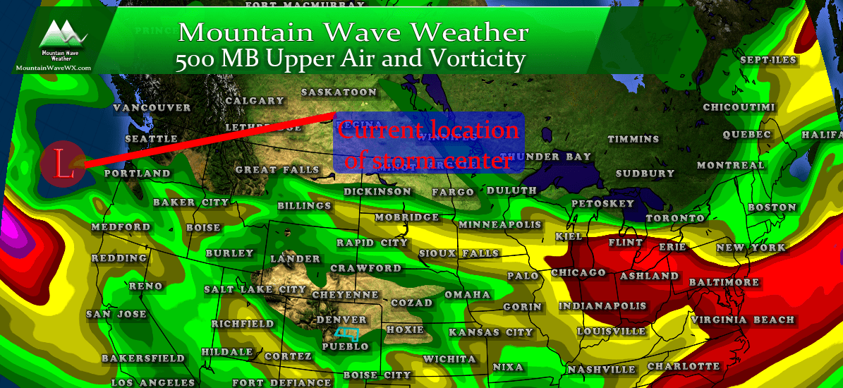
Storm System Brewing
I’ll show a couple of surface maps by some of the models coming in this afternoon. You’ll see a few differences in the finer details but the overall prediction on this system is similar between most of the models, hence why we are a bit concerned about it.
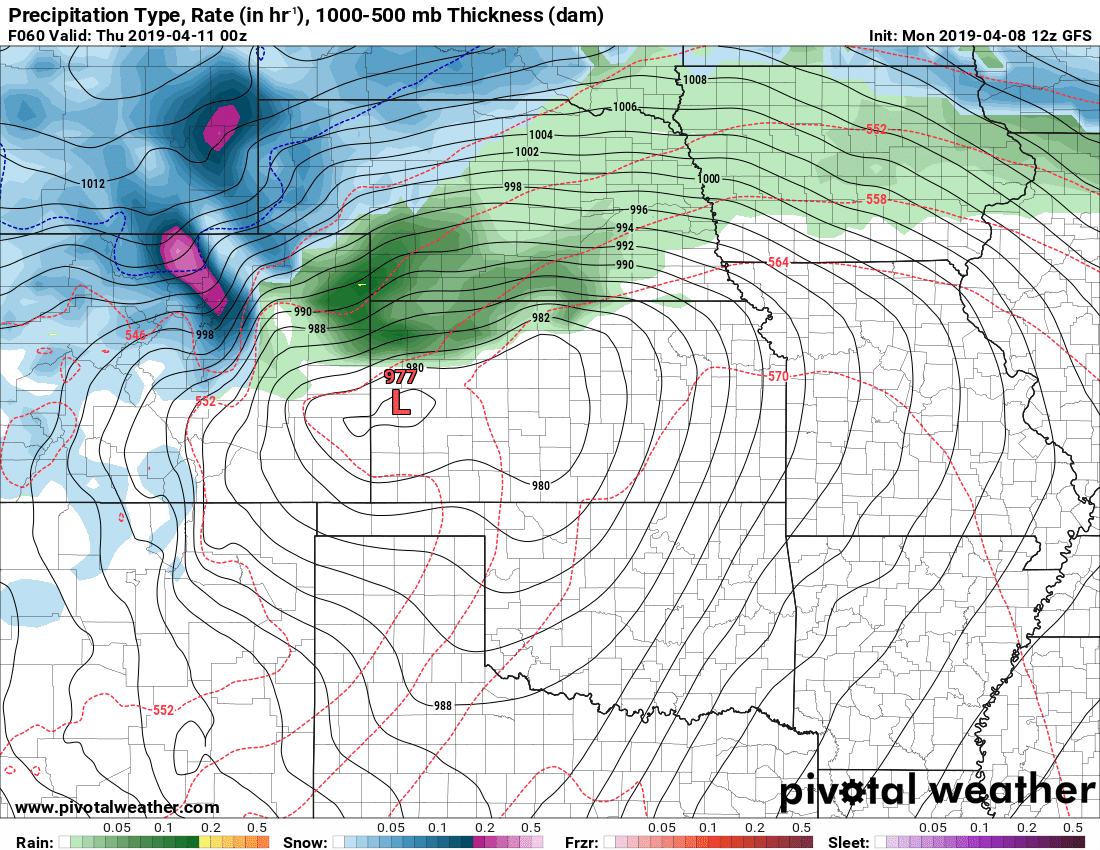
GFS predicted surface map at 6PM Wednesday night
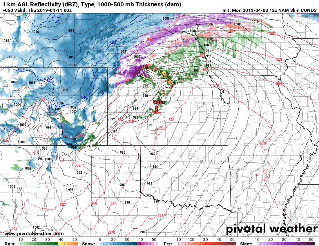
Nam3K surface map at 6PM Wednesday
Notice there are some differences in the storm track, positions and even timing of the low Wednesday evening. As with most snow related storms in Colorado, where the low sets up and how long it stays there are absolutely crucial. Any wobble can mean the difference between nothing at all or a ton of snow. As you can see, the finer details still aren’t solid enough for us to make a definitive call on how bad this storm will actually be. That being said, the POTENTIAL is there for a large, high impact storm and we will treat it as such.
***Potentially High Impact Storm!***
Our Forecast (As of this post) and What To Expect
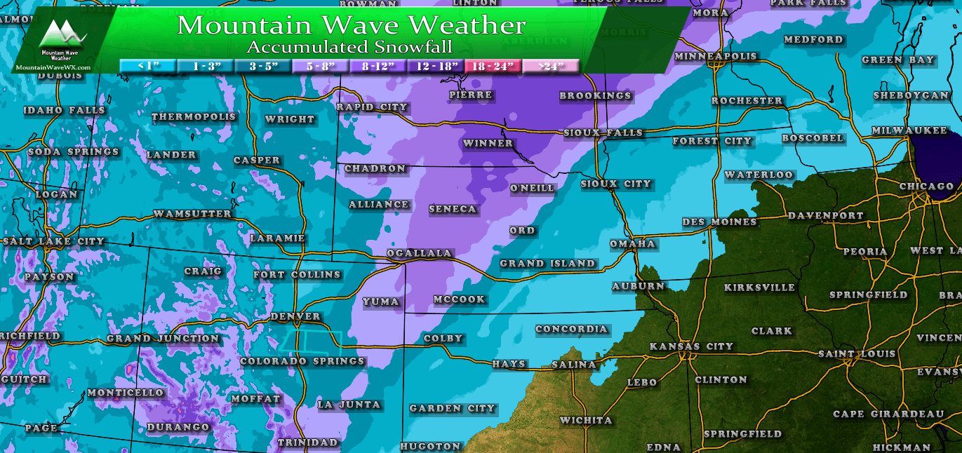
Expected Snowfall (through Thursday 12PM) *Preliminary, keep checking back for changes!*
*These are our forecast numbers and may not always match the NWS official forecast numbers*
- Castle Rock and surrounding areas
- 3-7 inches
- Parker, Lone Tree, Highlands Ranch areas
- 2-6 inches (concerns about lower snow amounts among lower elevations due to warm air)
- Elbert, Elizabeth, Kiowa
- 3-7 inches
- Larkspur, Monument
- 3-7 inches
- Woodland Park, Palmer Lake, W. Colorado Springs Foothills
- 3-7 inches
Timing
- Showers and storms kick off around mid-day on Wednesday, starting as rain for most areas
- Shorter term higher resolution models show a transition to snow by mid afternoon on Wednesday
- Highest impacts for travel look to be in the afternoon hours of Wednesday through Thursday morning
- Plan on potentially high impacts on travel. Areas of higher elevation South and East of Denver have the highest likelihood for severe travel impacts
Potential Impacts
- THE COMBINATION OF HIGH WINDS AND FALLING SNOW MEANS BLIZZARD CONDITIONS MAY BE POSSIBLE. We will keep an eye on this and be sure to pass along any information if we start to see Blizzard Warnings issued.
- We will be watching closely for any winter weather watches/advisories/warnings over the next 24 hours
- Ranchers and ag interests should take actions to prepare livestock and property for impacts
- This has the potential to be a high impact storm. Travel is not recommended later in the day Wednesday and into Thursday morning
Summary
So, another spring storm and it could be a doozy. Just like the last, there are still a lot of moving parts and variables to nail down but since this storm has the potential to be high impact… we are recommending folks in the Winter Storm Watch area begin making preparations for blizzard conditions.
Please stay tuned to your favorite reliable weather forecast over the coming days and of course we will have plenty of updates here and on our facebook!

Thanks, we appreciate the time it took for you to post this!
wow!!–some great information about the storm–thanks a million!! Am ready to hunker down and relax !!
Linda