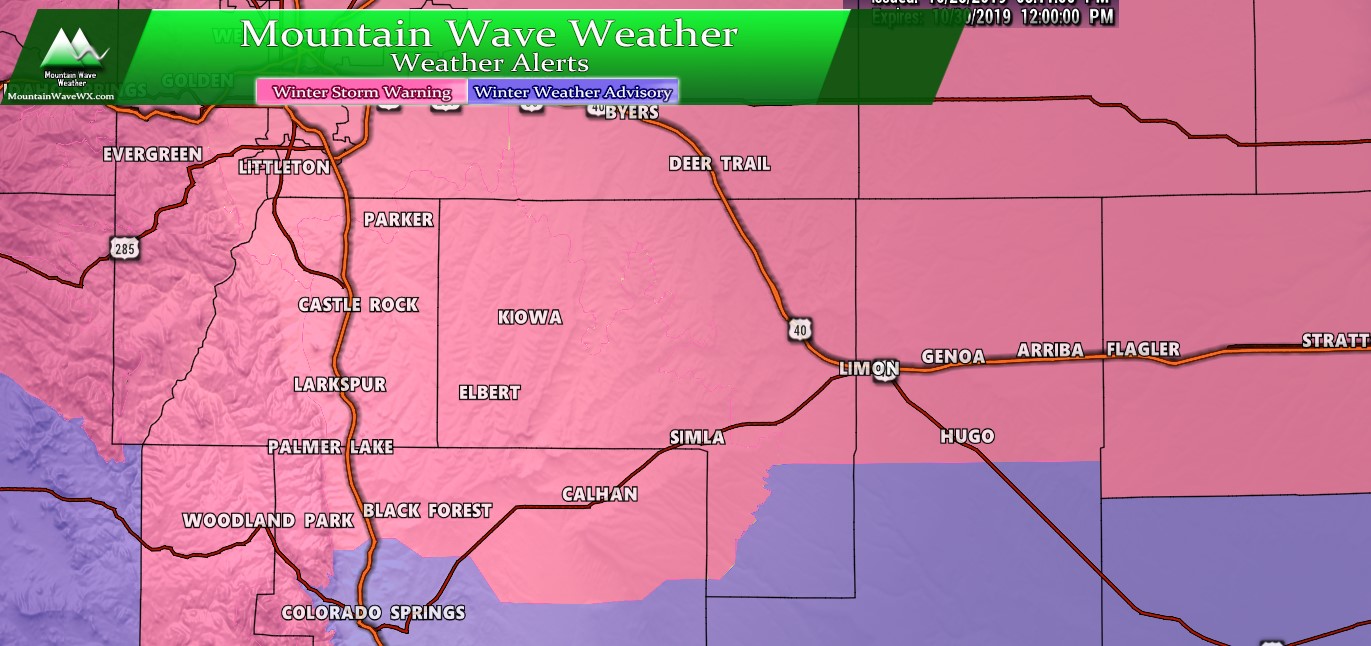
Watches/Warnings/Advisories
Palmer Divide weather highlights as of 4PM
***Winter Storm Warning***
In effect from Tuesday October 29, 2019 6AM – Wednesday October 30, 2019 12PM
Boulder and the western suburbs of Denver-Denver-Castle Rock-
Greeley-Fort Morgan-Byers-Limon-Akron-
Including the cities of Arvada, Boulder, Golden, Lakewood,
Longmont, Aurora, Brighton, City of Denver,
Denver International Airport, Highlands Ranch, Littleton, Parker,
Castle Rock, Elbert, Fondis, Kiowa, Larkspur, Eaton, Fort Lupton,
Greeley, Roggen, Brush, Fort Morgan, Goodrich, Wiggins, Bennett,
Byers, Deer Trail, Leader, Agate, Hugo, Limon, Matheson, Akron,
Cope, Last Chance, and Otis
311 PM MDT Mon Oct 28 2019

...WINTER STORM WARNING IN EFFECT FROM 6 AM TUESDAY TO NOON MDT
WEDNESDAY...

* WHAT...Heavy snow expected. Total snow accumulations of 6 to
  12 inches.

* WHERE...Portions of east central and northeast Colorado.

* WHEN...From 6 AM Tuesday to noon MDT Wednesday.

* IMPACTS...Travel is expected to be very difficult. The
  hazardous conditions are expected to impact the Tuesday evening
  and Wednesday morning commute. The cold wind chills as low as 15
  below zero could result in hypothermia if precautions are not
  taken.

PRECAUTIONARY/PREPAREDNESS ACTIONS...

If you must travel, keep an extra flashlight, food, and water in
your vehicle in case of an emergency.
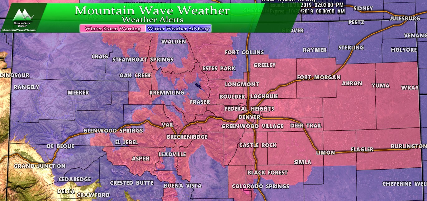
Colorado weather highlights as of 4PM
Forecast/Hazards/Timelines/Impacts (The Need to Know Planning Stuff!)
Impacts
Snowfall/Travel Impacts
- Minor impacts are possible to the Tuesday morning commute
- Moderate to high impacts to travel look most likely into Tuesday night and Wednesday morning
- Roads are expected to become icy and snow packed in the heaviest areas of snow. Be prepared for difficult and potentially dangerous travel conditions along the front range including Denver, Palmer Divide and areas North of Denver especially later in the day Tuesday through Wednesday morning.
Timing
- Tuesday
- Light snow is possible Tuesday morning but accumulations look light for any areas that do see snow.
- Heaviest snow looks likely after 3PM as of this update
- Heavy snow and wind will be likely for many areas going into Tuesday evening and overnight
- Wednesday
- Heavy snow overnight and cold temperatures means the commute Wednesday morning will see moderate to high impacts
- Snow is expected to continue through the day Wednesday with the heaviest accumulations in the morning.
- Snow begins to taper off after 12PM with clearing towards evening
- Extremely cold temperatures will be possible overnight Wednesday into Thursday
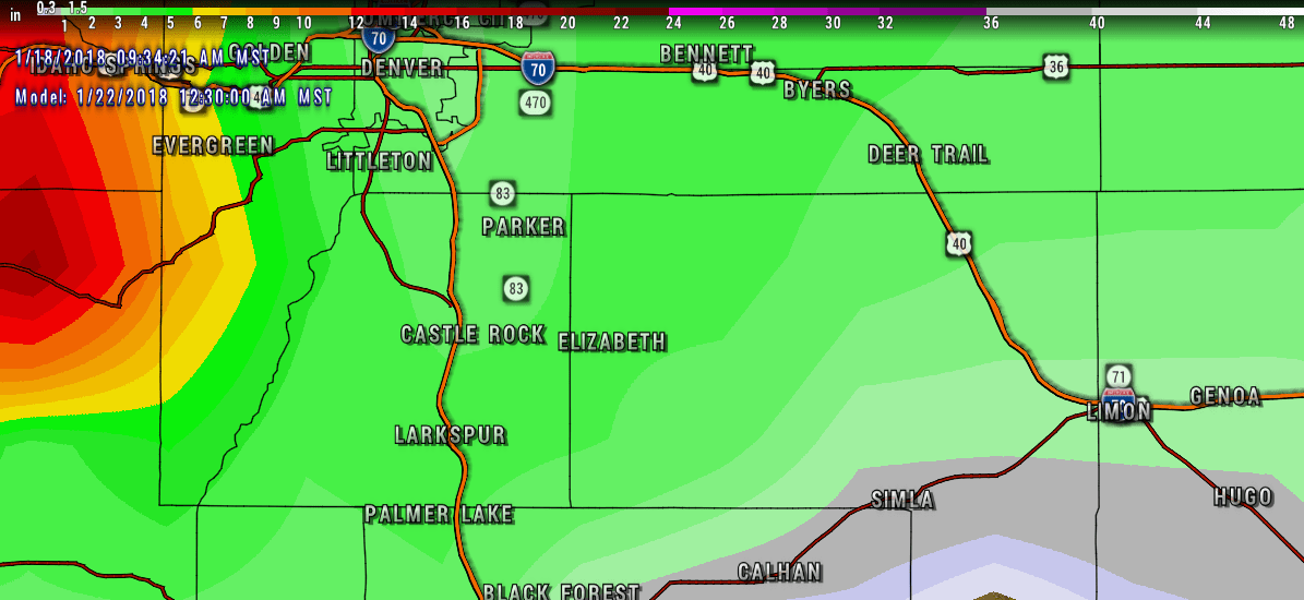
Snowfall
So far the models are showing a much better organized storm with a favorable track for heavy snow than the last. This is a preliminary snowfall forecast, be advised that these totals may change late tonight and possibly again by tomorrow morning as we get more data in.
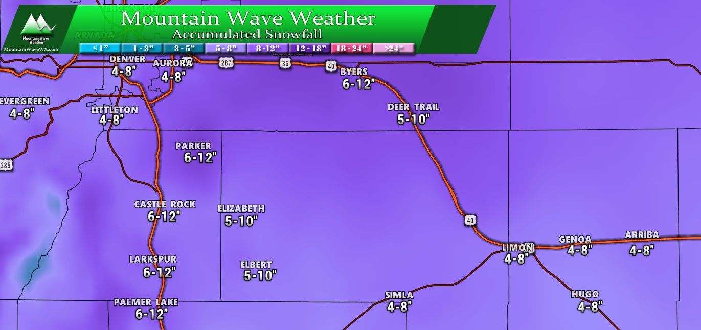
Palmer Divide estimated snowfall through Wednesday 3PM
We will be watching closely and adjust snow totals as needed. There is at this time a decent chance they may be adjusted upwards so stay tuned!
Summary
A one-two punch for us this cold and snowy October. This storm looks a lot more powerful than the last so keep a close eye on the forecast. The way it’s looking you probably want to be off the roads by Tuesday evening and plan for the same Wednesday morning.
As always I’ll pass along any updates (next forecast update most likely quite late Monday night and early Tuesday) Stay tuned!


I was skeptical that the storm would start as early as 6AM, but here we are and snow is coming down. Douglas County is keeping schools open, but canceling after school activities/events. Snow totals were lowered, so by this afternoon are we only expecting a scant amount still with heavier snow overnight? Or will snow peter out by bedtime?