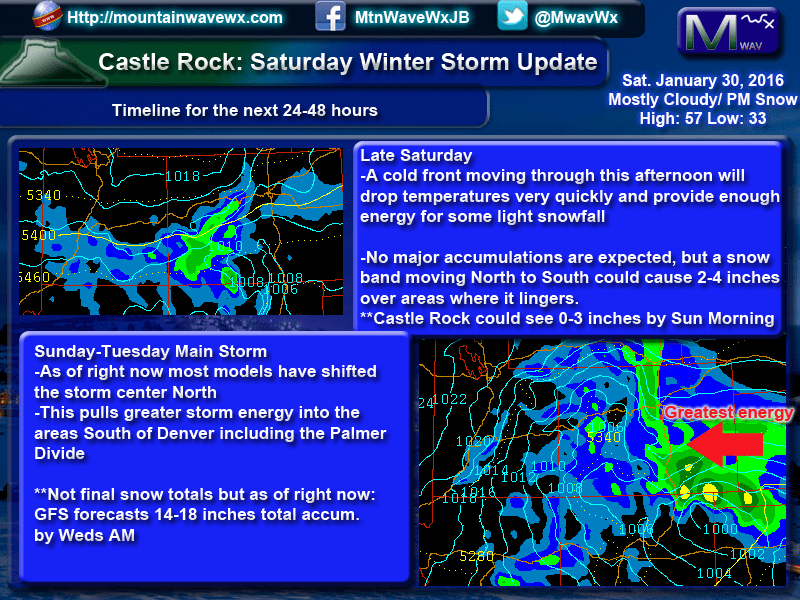
What we know for sure as of this morning:
- Nearly all models are in agreement that Colorado and especially the front range will see snow during the Sunday – Tuesday night period
- The mountains and foothills will see heavy snow
- Winds of 15-25 knots (17-28 mph) will be possible during the storm along the front range, this could create considerable blowing and drifting of snow
- Front range could see periods of heavy snow and wind, especially later in the day Monday and overnight into Tuesday
- Most models show between 10-25 inches total snowfall for this storm. Please keep in mind, this is still very early and we expect those numbers to change significantly in the next 24-48 hours
This Could be a High Impact Storm
We continue to stress that should this storm set up correctly, the snowfall numbers won’t be the issue to look at. What will be important is the impact, at the end of the day, does it matter if you get 2 feet or 3 feet of snow if all the roads are closed and you are not able to travel? Nope! This storm is not really 50/50 anymore, it is more like 60/40 leaning towards a significant storm, this confidence should trend upwards with more consistent model runs today.
Use Saturday as your preparation day for these impacts!
- A prolonged period of heavy snow and high winds is expected
- Roads will become icy and snow packed, roads to our East may become impassable due to drifting snow
- Airline cancellations and delays will be very likely
- School and business closures will be possible
- Travel will become very treacherous at times
Get your errands done today, get to the store and don’t leave anything to the last minute. Be prepared! Stay tuned here and we will provide more updates as this storm system evolves. Happy Saturday!



I really appreciate your input John…
Thank you Brian!
How does the fountain co. Area look??
Hi Joe,
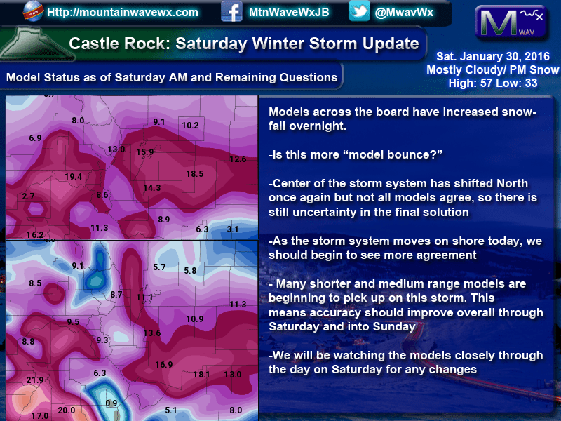
This will depend a lot on how the storm system finally sets up. Some models have a southern bias, which means areas in the springs and south will see more than areas North of the springs. As of this morning, the snowfall range (based on the model runs) shows that area with a range between 6-12 inches. Right now most of the models average out right around the 10 inch range, but this may wobble higher or lower as we go throughout the day.
Here’s a look as of this morning:

Just came across your page. How often do you update?
Hi Kim,
When there’s something significant going on with the weather, I usually try to have a couple updates per day or if there is severe weather I’ll post quite a bit. When the weather is quieter usually I’m not posting as much, maybe a few times per week.