Current Weather Watches/Warnings/Advisories
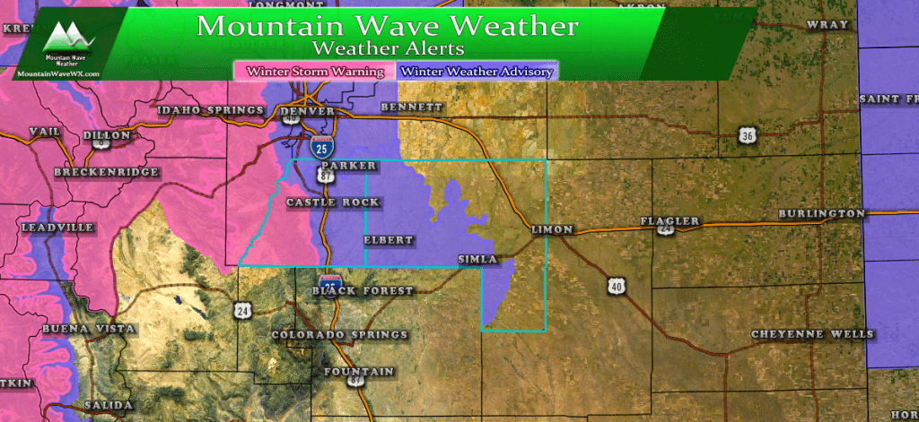
NWS has issued Winter Storm Warnings and Winter Weather Advisories for this storm
Winter Weather Advisory
...WINTER WEATHER ADVISORY IN EFFECT FROM 9 AM SATURDAY TO 11 AM
MST SUNDAY...

* WHAT...Snow expected. Total snow accumulations of 4 to 7 inches
  expected.

* WHERE...Boulder and the western suburbs of Denver, Denver,
  Castle Rock and Greeley.

* WHEN...From 9 AM Saturday to 11 AM MST Sunday.

* ADDITIONAL DETAILS...Plan on slippery road conditions.

PRECAUTIONARY/PREPAREDNESS ACTIONS...

A Winter Weather Advisory for snow means periods of snow will
cause primarily travel difficulties. Expect snow covered roads
and limited visibilities, and use caution while driving.
Winter Storm Warning
...WINTER STORM WARNING IN EFFECT FROM 9 AM SATURDAY TO 11 AM MST
SUNDAY...

* WHAT...Heavy snow expected. Total snow accumulations of 6 to 12
  inches expected.

* WHERE...The Southern Front Range Foothills.

* WHEN...From 9 AM Saturday to 11 AM MST Sunday.

* ADDITIONAL DETAILS...Plan on slippery road conditions.

PRECAUTIONARY/PREPAREDNESS ACTIONS...

A Winter Storm Warning for snow means severe winter weather
conditions will make travel very hazardous or impossible. If you
must travel, keep an extra flashlight, food and water in your
vehicle in case of an emergency.
Please be aware, Castle Rock is not under the Winter Storm Warning. Only the western parts of Douglas County in the foothills.
Our Forecast (As of this post) and What To Expect
Expected Snowfall (through Sunday 12PM) *Preliminary, keep checking back for changes!*
*These are our forecast numbers and may not always match the NWS official forecast numbers*
- Castle Rock and surrounding areas
- 3-7 inches
- Parker, Lone Tree, Highlands Ranch areas
- 4-9 inches
- Elbert, Elizabeth, Kiowa
- 2-6 inches
- Larkspur, Monument
- 4-8 inches
- Woodland Park, Palmer Lake, W. Colorado Springs Foothills
- 5-10 inches
Timing
- Light snow shower were already being reported in several areas as of after 12PM Friday
- Snow shower activity will continue and be spotty in nature through Friday night into Saturday morning
- Thunder and graupel/ convective snowfall is possible Friday afternoon/evening
- Widely scattered snow showers into Saturday morning (most of heavier snow action remains North of Denver)
- Snow intensity and coverage should pick up by the afternoon hours on Saturday for the Palmer Divide
- Heavy snow in some areas will be possible Saturday evening into Saturday night
- Lingering snow showers could continue through Sunday morning but should be light as the day goes on.
Potential Impacts
- Likely travel impacts will be slick roads with some accumulating snow on road surfaces
- Highest travel impacts look like Saturday evening/night and overnight into early Sunday
- Stay tuned in case the storm position changes and thus the impact area
Summary
Another very complex and constantly evolving storm system, but that’s been the name of the game so far this year. I’m not super excited about higher snowfall totals out of this storm just yet… model data is not strong that areas South of Denver will do super well… but we shall see!
Here’s 2 of the WPC forecast for snowfall…
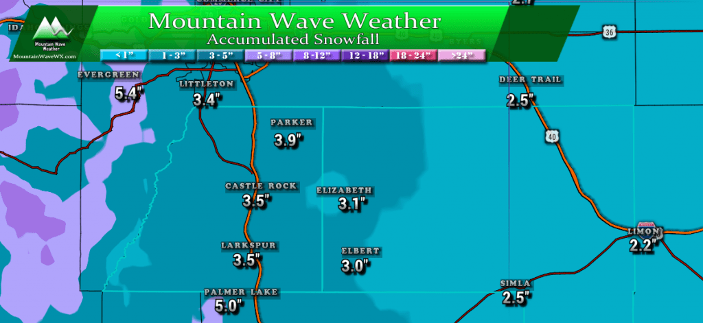
25th% or slightly less than expected snowfall prediction by WPC
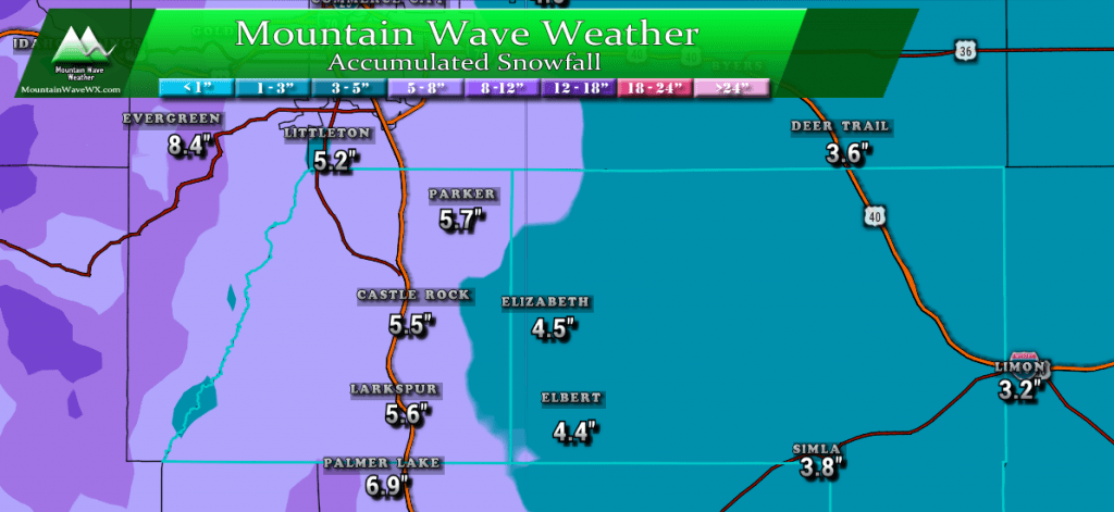
50% or expected (most likely) amount of snowfall from WPC
The reason I show both graphics above is because my forecast falls somewhere in between these. I’m concerned the track of the storm and how long it ends up setting up along the front range. There are a lot of “timing” complexities that need to come together for higher end snowfall totals and given the data I’m seeing today it is slightly more likely the snowfall ends up on the lower end of the ranges for the Palmer Divide.
Still, we can’t rule out heavy snowfall banding and the potential the storm track shifts; meaning we very well could bust high on this one too… but only in very localized places. (Those darn heavy snow bands have a way of mucking up forecasts for some localities.)
Take my forecast above as a preliminary guideline; snow in some form will be likely and cold temperatures Saturday through Monday are a dead lock. Be prepared for slick driving conditions and remember to take warm clothes if you will be out and about!
Stay tuned, we will update the forecast as we get more data in!



We appreciate your incite! Thanks from south Parker!
Thank you Dan!
I was referred to you by a friend, Jerry Morrison. I think you are linked to his weather station at his home in Castle Rock.
I appreciate your forecasts and rely on them for my job as a Realtor.
Keep up the great work.
Roy
Thank you Roy! Yup, I watch his station and chat with him regularly!