We look to have ourselves another powerful spring storm on the way to Colorado. As of this morning, many areas along the front range had already seen a healthy dose of rain and that doesn’t look to change through the day today. What will change is the rain will transition to snow by sometime this evening and once it does and the sun goes down, we should see snow begin to accumulate in higher elevation areas. (Thinking the best shot is areas over 5500 feet at this time.
Here’s the latest on this storm!
Weather Watches/Warnings/Advisories

Updated watches, warnings and advisories in Colorado as of 1PM on May 8, 2019
Cameron Pass,
Laramie and Medicine Bow Mountains, Rabbit Ears Range,
Rocky Mountain National Park, Willow Creek Pass, Estes Park,
Glendevey, Nederland, Red Feather Lakes, Bailey, Central City,
Evergreen, Georgetown, Idaho Springs, and Westcreek
More details with this advisory:
...WINTER WEATHER ADVISORY REMAINS IN EFFECT UNTIL 6 PM MDT
THURSDAY...

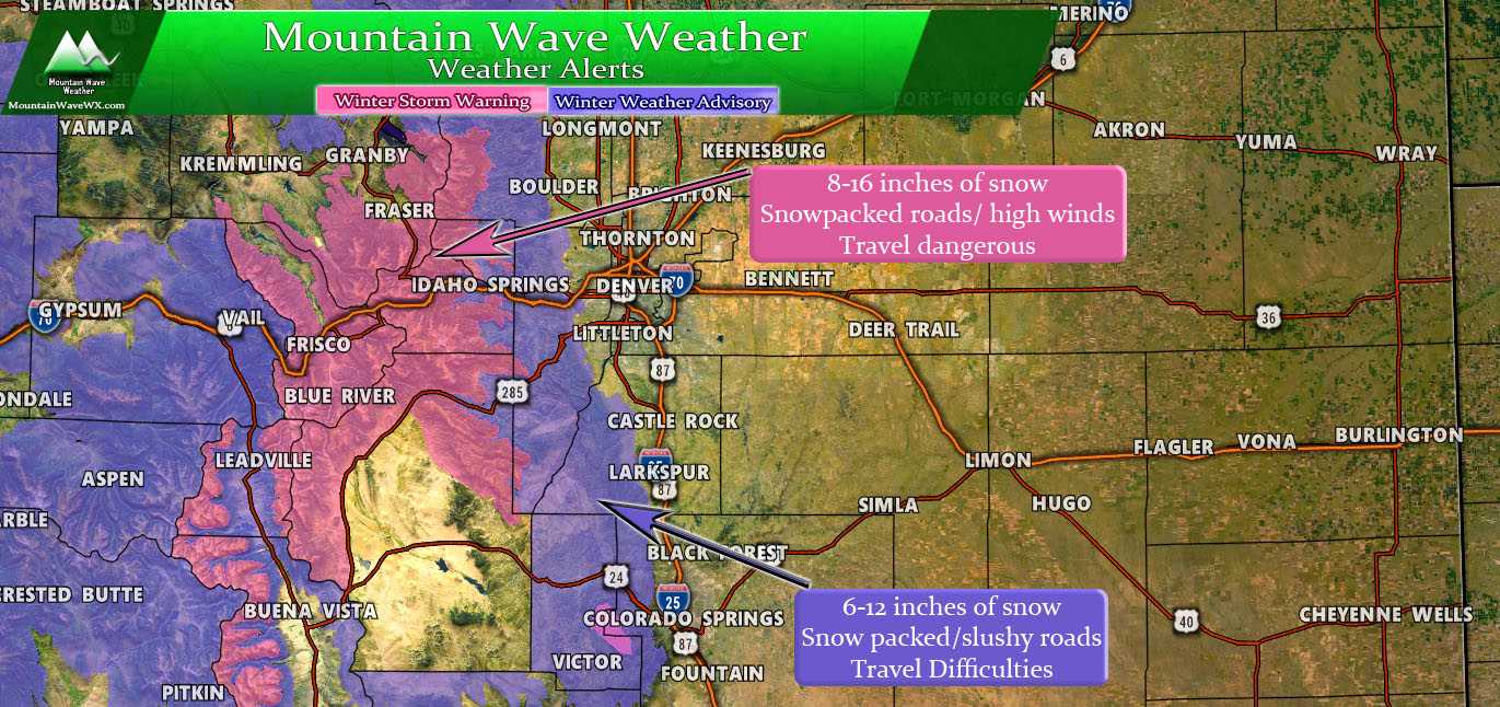
* WHAT...Snow expected. Total snow accumulations of 6 to 12
  inches expected.

* WHERE...Southern Front Range Foothills.

* WHEN...From noon Wednesday to 6 PM MDT Thursday.

* ADDITIONAL DETAILS...Travel could be hazardous with slushy and
  snow covered roads at times.

PRECAUTIONARY/PREPAREDNESS ACTIONS...

A Winter Weather Advisory for snow means periods of snow will
cause primarily travel difficulties. Expect snow covered roads
and limited visibilities, and use caution while driving.
A Winter Storm Warning is in effect for mountain areas and will feature between 8-16 inches of snow. Combined with high winds especially over the passes, we expect mountain travel to become very difficult if not hazardous by later Wednesday.
Here’s the details on that warning:
...WINTER STORM WARNING REMAINS IN EFFECT UNTIL 6 PM MDT
THURSDAY...

* WHAT...Heavy snow expected. Total snow accumulations of 8 to
  16 inches expected.

* WHERE...The Mountains of Summit County, the Mosquito Range,
  and the Indian Peaks.

* WHEN...From noon today to 6 PM MDT Thursday.

* ADDITIONAL DETAILS...Travel could be very difficult. The
  hazardous conditions could impact the morning or evening
  commute.

PRECAUTIONARY/PREPAREDNESS ACTIONS...

A Winter Storm Warning for snow means severe winter weather
conditions will make travel very hazardous or impossible. If you
must travel, keep an extra flashlight, food and water in your
vehicle in case of an emergency.
Closer to Home… Our Palmer Divide Forecast
Expected Snowfall (through Thursday 8AM)
*These are our forecast numbers and may not always match the NWS official forecast numbers*
- Castle Rock and surrounding areas
- 2-5 inches
- Parker, Lone Tree, Highlands Ranch areas
- 2-5 inches
- Elbert, Elizabeth, Kiowa
- 3-6 inches (will be watching higher elevations!)
- Larkspur, Monument,Black Forest, Palmer Lake,
- 3-6 inches — Black Forest totals may be lesser in lower elevations
- Woodland Park, W. Colorado Springs Foothills
- 5-10 inches (especially higher elevation foothills areas West of Colorado Springs)
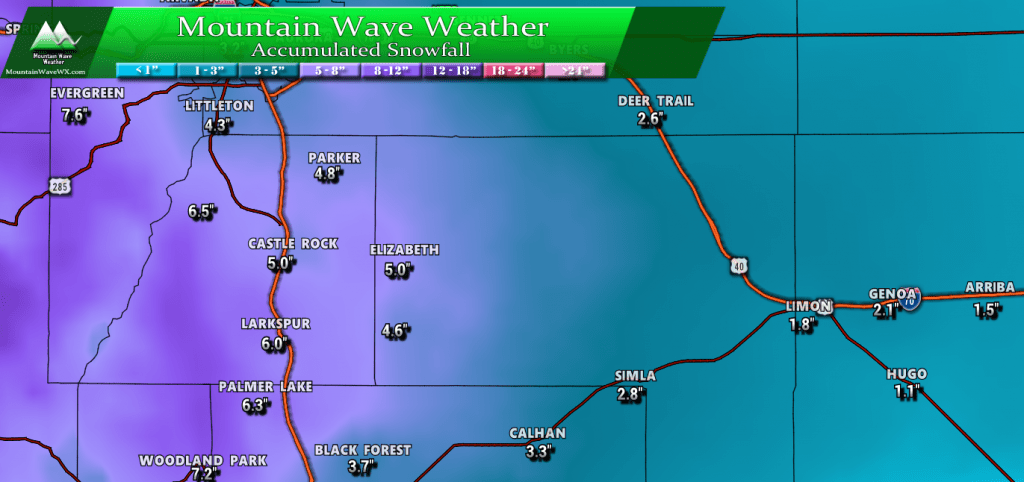
WPC snowfall at 25th percentile. I like to use this number more in the spring as it can help account for melting and compacting. Still relatively respectable snowfall amounts it’s indicating!
Timing
- Precipitation has already started as rain this morning across the Palmer Divide
- Models show rain turning to snow sometime between 5-8PM. Expecting little accumulation during daylight hours but as the sun goes down accumulation becomes more likely.
- Highest chance for accumulating snowfall for the Palmer Divide looks to be the late evening hours Wednesday through early Thursday morning
- There’s a lot of moisture with this storm, snow may be moderate to heavy at times in very specific spots
Potential Impacts
- We don’t expect major travel impacts with this storm at this time
- Roads under sustained heavier snow may become slushy, this is most likely at higher elevations. Some minor to moderate travel impacts may be experienced.
Summary
This storm looks a bit more promising than our last “snow” storm. A combination of a low pressure system spinning moisture into Colorado from the South and a strong low pressure system funneling cold air in from the North means this is a better setup for snow overall.
But just keep in mind, with this storm as with many spring setups; the exact positioning of where these features set up as well as when they make it in to the state (timing) makes all the difference.
We will keep an eye on things and pass along any updates!



Thanks!