A strong and fast moving storm will make its way through Colorado this week. What’s interesting is some of the snow totals some models are spitting out vs. the fact that storms with this track and speed rarely amount to big snowfall for parts of the front range. Not only that, but models are still showing a ton of uncertainty with the storm track, who sees the most moisture and even where the upslope and downslope sets up.
As the timing of this storm is late Wednesday and into Thursday, we have no problem showing the models with this storm at this point, but keep in mind… with this much uncertainty across the spectrum, most of these are bound to change (maybe even drastically) in the next 24-48 hours. With that, here is a look and our thoughts:
GFS
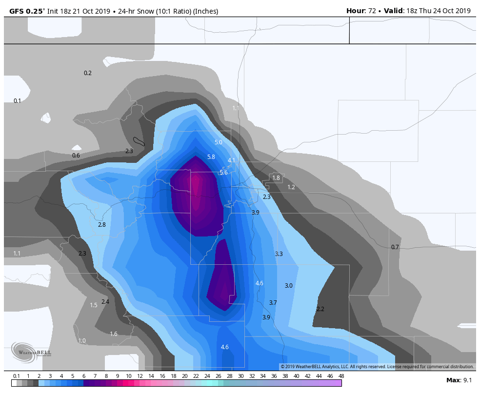
GFS snowfall through 12PM Thursday
The GFS is a bit wonky outside of 48 hours but as we are getting close to that timeframe and it nailed the last storm pretty well we have to give it a look. The GFS has been less than excited about the snowfall potential in most of its runs and the latest show (data still coming in at time of this post) pretty much nixes snowfall North of the Palmer Divide completely. If this solution verifies we would look for 2-4 inch range realize in and around Castle Rock with 1-3 for points East of there (out into Elbert County) and some foothills areas of Douglas Count in the 4-8 inch range.
EURO
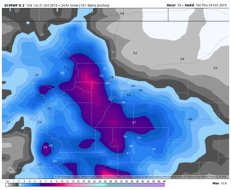
EURO 24hr snowfall through 10AM Thursday
The Euro has been pretty heavy on snowfall throughout the past couple of days, but even today it has backed off a bit. We always pay close attention to this model because it is by far the most accurate within 72 hours with decent accuracy beyond that (but like all models it falls quickly after 3-5 days.) This particular model shows a more substantial event for the foothills and Palmer Divide. If this model were to verify I’d expect 4-8 inches in and around Castle Rock and points East right along the Palmer Divide. It would be possible areas in and around the foothills in Douglas County could see 5-10 inches.
**Please note, the EURO has continuously been backing off these high totals in the past few runs so our confidence in these ranges is quite low at this point in time.
NAM
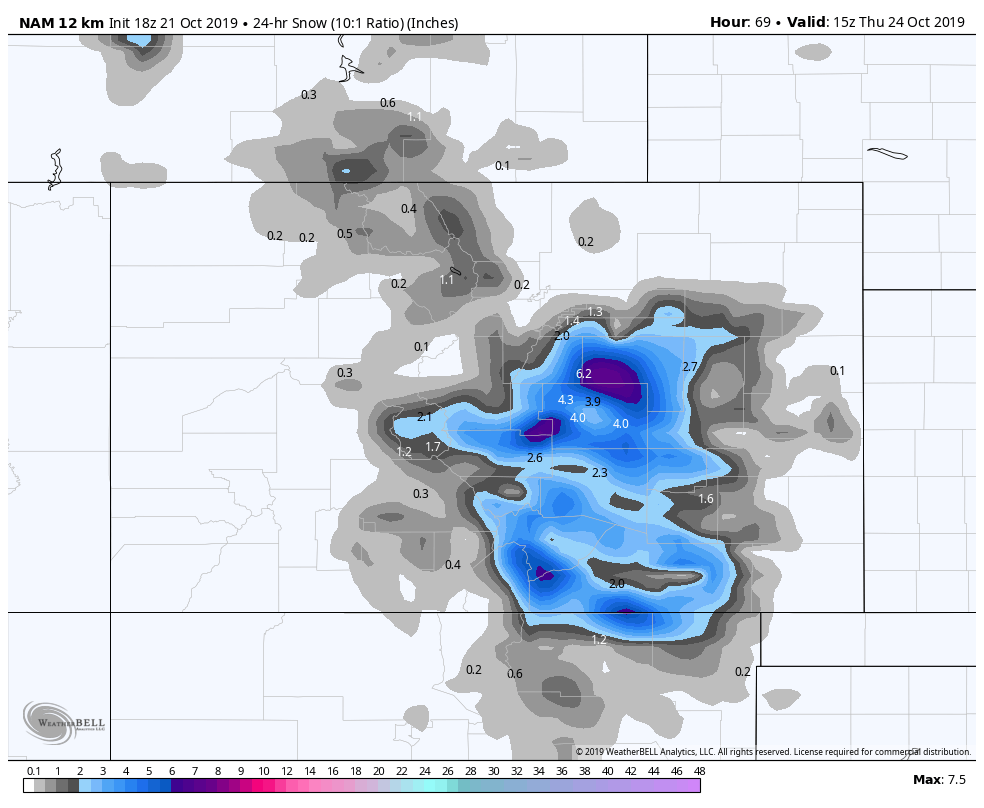
NAM 24 hr snowfall through 9AM Thursday
The NAM has just come in range and it like the GFS is not terribly impressed with this storm overall. It does however, highlight the areas right along the upper elevations of the Palmer Divide as a bullseye. This model points out Southwestern and South Central Elbert and Northern El Paso counties as areas that see the most snow. Should this model verify I’d expect to see 1-3 inches in and around Castle Rock with 3-6 inches possible East of town into Elbert and El Paso counties. Colorado Springs may also see decent accumulation with this scenario.
Canadian (For the heck of it)
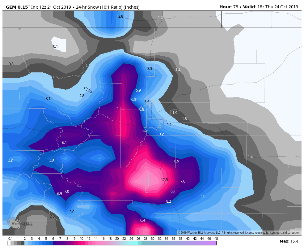
Canadian (GEM) 24 hr snowfall through 12PM Thursday
I want to say up front, I hate this model more than about 24-48 hours out. It tends to grossly over-estimate snowfall and for that reason I tend to throw it out a lot… but for the heck of it I’ll post it up for this update.
I imagine a lot of folks seeing ridiculous snow totals on their weather apps today were seeing a blend of this model with the EURO perhaps. If this were to verify I’d expect 5-10 inches for Castle Rock and surrounding areas with higher elevation areas of the Palmer Divide seeing 6-12 inches and parts South towards and West of Colorado Springs getting completely hammered. Those areas could see between 8-16 inches of snow.
Want to emphasize though, this is probably the lowest confidence model in this post. The only thing of value I see is the overall pattern that some of the other models are showing that this may be more of a Southerly event. Meaning I’d expect areas South of Castle Rock, over Monument Hill and into the springs to have the highest chance of seeing decent snowfall.
SREF and EURO Ensemble
I like to post these two products because the ensemble means can shed a bit more light on whether we should be concerned about this storm or not. These products take several operational model runs with slightly different parameters and average them out, the mean is a result of all these taken together.
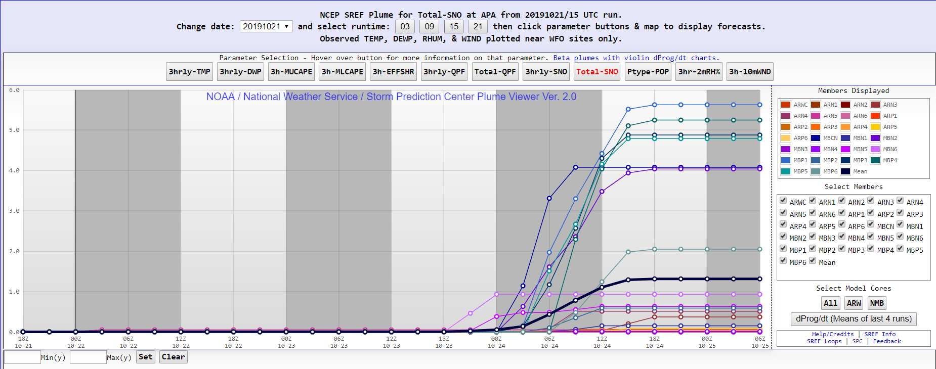
SREF ensemble mean
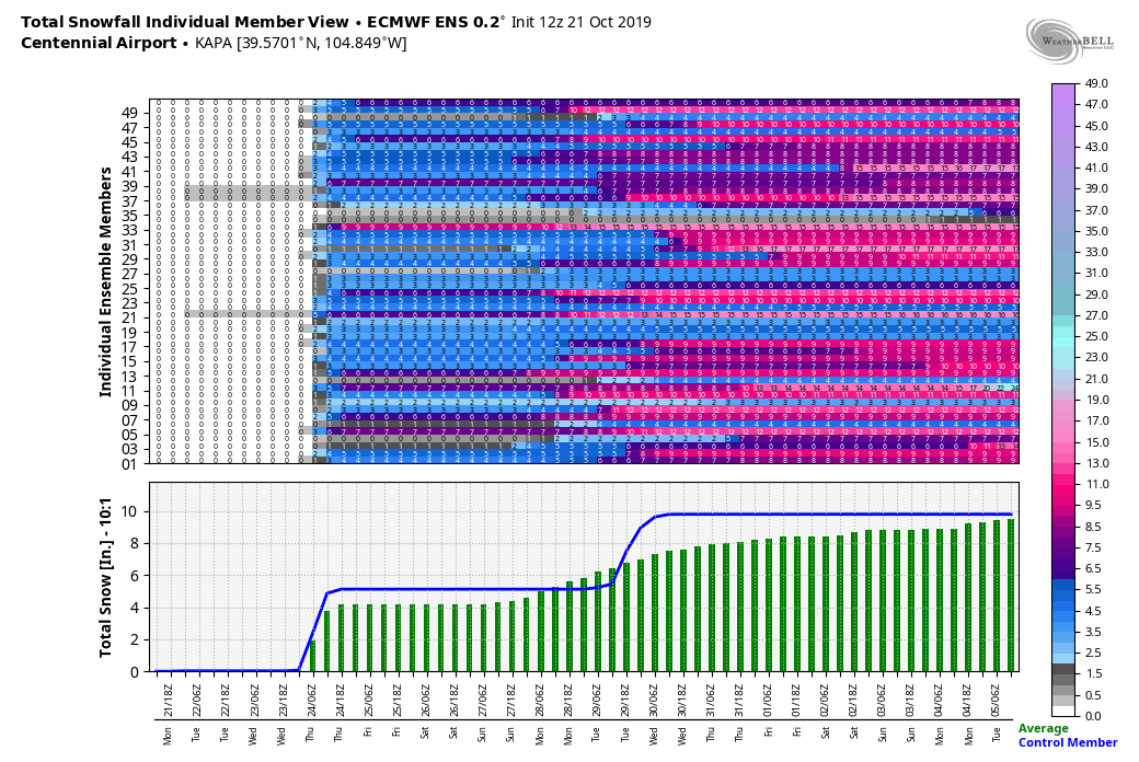
EURO ensemble mean
As you can see, the mean for both of these products is less than their operational counterparts above (except for that pesky Canadian.)
Summary – What You Need to Know
Like all storms this information WILL change within the next 24-48 hours but we will paint a quick picture of what to expect as of this evening’s data.
Timing
- Overnight Wednesday into Thursday morning
- Most models don’t show an impact to Wednesday evening commute, but timeframe can shift so keep a look out
Impacts
- Be prepared for potential travel impacts late Wednesday night into Thursday morning
- Possible impacts to Thursday morning commute. Most concerned about this manifesting in areas South of Denver into the Springs
- Slick roads, wind and snow will be possible into early Thursday morning.
That’s what we know for now. Given the uncertainty we cannot get an exact bead on snowfall totals just yet, but stay tuned for those preliminary amounts on Tuesday with clarity Tuesday night into Wednesday.
Doesn’t look like a major storm as of yet but the potential is there. Uncertainty is high and forecast confidence is low, so stay tuned for changes and refinements as we get closer to the storm event.


I don’t have snow tires on yet. This is scary. I live in Castle Rock so I’m NOT looking for an accident or slip sliding