Model guidance is continuing to suggest a very wet and soggy storm system to affect the area later this week and into this weekend. While this storm shows a lot of similarities to our blizzard we had just a couple of weeks ago there are some big differences as well. This storm is showing no signs we need to go raid the grocery stores as of this time.
- Similarities
- This storm has a ton of moisture, just like the last one it taps into gulf moisture and spins this into the state giving us ample up slope to produce precipitation
- It is very slow moving. Many models have the affects of this storm being felt from Thursday this week into Tuesday next week
- Differences
- This storm looks to have trouble tapping into colder air form the North. This means more precip may fall as rain and snow may take longer to accumulate, diminishing overall totals
- Because of the first point, temperatures will remain warmer overall. A single degree warmer or colder makes a huge difference in the spring-type storms
- The storm track is slightly further South meaning we would see the best snow further South. Areas along the Palmer Divide and into Springs will see the most moisture, but elevation will play a key role in snowfall amounts
Model Guidance on Snowfall as of This Morning
(Again, not official forecasts. These are just a look at models at this time)
 |
GFS (Long Range Model)Storm Total Accumulation by Saturday April 30, 2016 12:00PM The GFS shows snowfall along the front range Using 10:1 Ratio: 3-6 inches of snow |
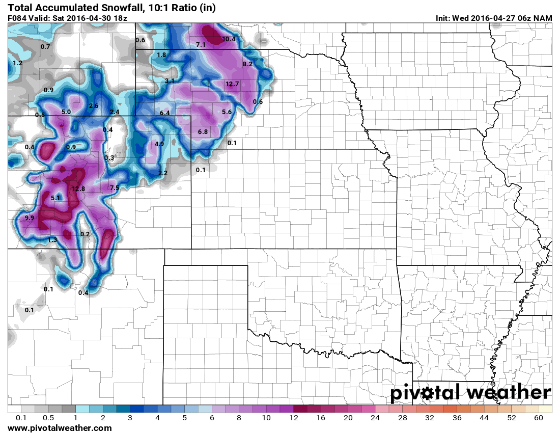 |
NAM (Medium Range Model)Storm Total Accumulation by Saturday April 30, 2016 12:00PM The NAM shows lesser snow accumulation Using 10:1 Ratio: 1-3 inches of snow |
 |
NAM4K (Short-Medium Range High Resolution Model)Storm Total Accumulation by Friday April 29, 2016 12:00PM The NAM 4K’s range only goes through Friday Using 10:1 Ratio: 1-3 inches of snow |
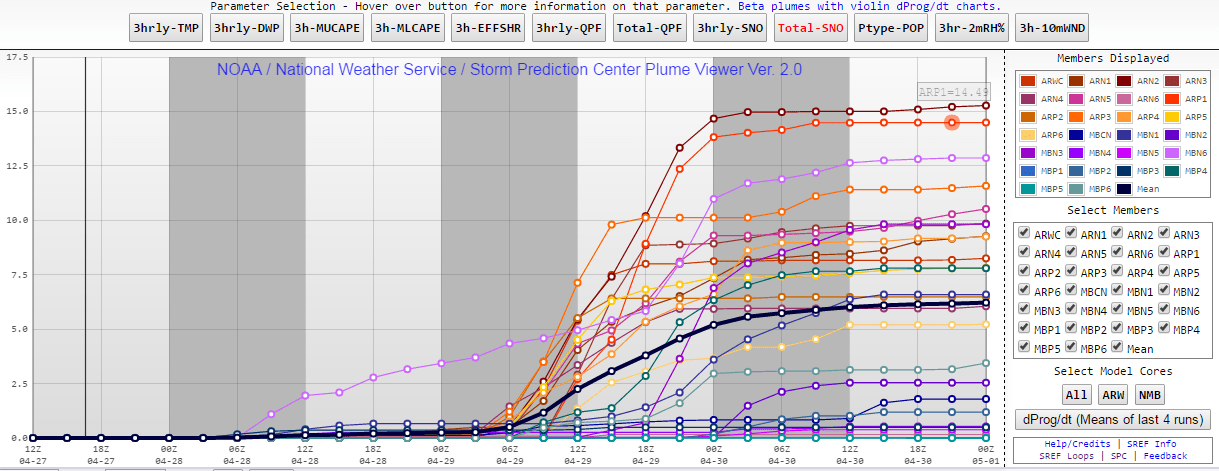 |
SREF Ensemble (Short Range Model Ensemble)Storm Total Accumulation by Saturday April 30, 2016 6:00PM The SREF is a combination of a bunch of model This model shows a solution more in line with the |
Current Winter Weather Watches/Warnings/Advisories
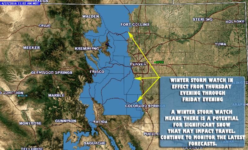
This watch does not include Central or Eastern Douglas County as of this time. Castle Rock is not included.
**Winter Storm Watch In Effect**
Timing
WINTER STORM WATCH IN EFFECT FROM THURSDAY EVENING THROUGH
FRIDAY EVENING
Cities/Areas Included
CAMERON PASS...
LARAMIE AND MEDICINE BOW MOUNTAINS...RABBIT EARS RANGE...
ROCKY MOUNTAIN NATIONAL PARK...WILLOW CREEK PASS...
BERTHOUD PASS...BRECKENRIDGE...EAST SLOPES MOSQUITO RANGE...
EAST SLOPES SOUTHERN GORE RANGE...EISENHOWER TUNNEL...
INDIAN PEAKS...KENOSHA MOUNTAINS...MOUNT EVANS...
WILLIAMS FORK MOUNTAINS...WINTER PARK...ESTES PARK...GLENDEVEY...
NEDERLAND...RED FEATHER LAKES...BAILEY...CENTRAL CITY...
EVERGREEN...GEORGETOWN...IDAHO SPRINGS...WESTCREEK...FAIRPLAY...
HARTSEL...LAKE GEORGE...SOUTH PARK
Snowfall
GENERALLY 10 TO 20 INCHES. FAVORED UPSLOPE
AREAS EAST OF THE CONTINENTAL DIVIDE WILL SEE THE MOST SNOW...
WITH TOTALS PERHAPS APPROACHING TWO FEET.
Impacts
ACCUMULATING SNOW ON BRANCHES AND POWER LINES COULD
LEAD TO TREE DAMAGE AND POWER OUTAGES. ROADS WILL AT LEAST GET
SLUSHY THURSDAY NIGHT AND FRIDAY NIGHT BUT DUE TO THE HIGH SUN
ANGLE DURING THE DAY ON FRIDAY THEY MAY NOT EXPERIENCE A LOT OF
ACCUMULATION DURING THE DAYLIGHT HOURS.
Summary
At this time there is no reason to panic with this storm. With what we are seeing now it looks like it will at worst be an inconvenience for folks below 7,000 feet in elevation on Friday and possibly Saturday. This storm does not look like it will produce the type of snowfall that will trap you in your house so no reason to run on the grocery stores.
We will continue to keep an eye on the forecast and relay any changes in forecast through the day Wednesday and Thursday regarding higher or lower snowfall amounts. Stay tuned!
