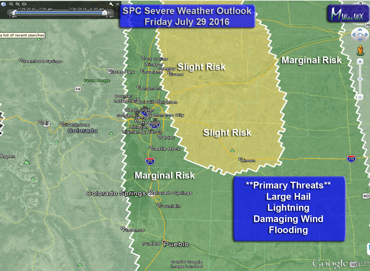
Severe weather moved through the area last night, luckily missing a lot of folks but unfortunately the folks who saw the severe storms suffered some pretty significant damage. The Storm Prediction Center has a severe weather outlook for the front range of Colorado today. A slight risk area extends just East of the Urban corridor out towards Limon and up North to the Wyoming border. A marginal risk area encompasses the slight risk area and includes basically any area East of the foothills to the Kansas border.
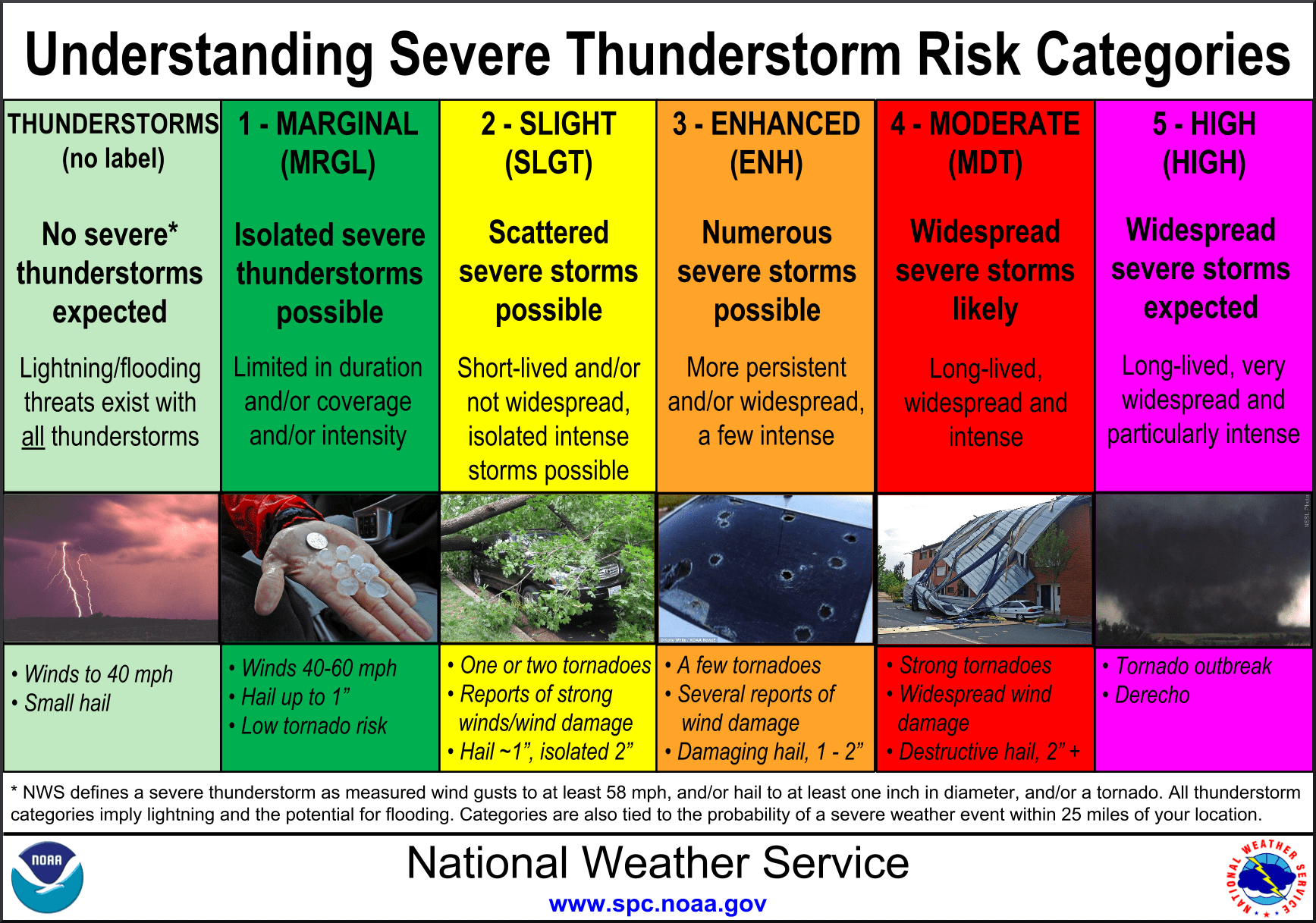
As a refresher, here is what the thunderstorm risk categories mean. For those of us in the marginal risk area, storms will be very isolated so most areas in the threat area will see no severe weather or possibly no storms at all. The few storms that do develop will have the potential to grow severe. The slight risk area has many of the same characteristics but the probability of seeing a severe storm in that area is higher.
Parts of Colorado Springs See Hail Damage
A series of severe storms moved through the area last night with the worst converging over parts of Southeastern Colorado Springs.
See also: Read about the storm from local news station KKTV 11 from Colorado Springs
The Colorado Springs Police Department is also reporting damage to several police cruisers, I imagine many residents will see similar damage to their cars and homes as a result of this storm.
Friday’s Severe Weather Threat
SPC text:
...CENTRAL HIGH PLAINS THIS AFTERNOON/EVENING...
   WEAK LOW-LEVEL ELY/UPSLOPE FLOW WILL PERSIST TODAY BENEATH MIDLEVEL
   WNWLY FLOW OF ROUGHLY 30 KT ACROSS WY/NE CO.  LINGERING BOUNDARY
   LAYER DEWPOINTS IN THE MID-UPPER 50S AND STEEP MIDLEVEL LAPSE RATES
   WILL SUPPORT MODERATE BUOYANCY E OF THE LARAMIE RANGE AND CO FRONT
   RANGE BY MID-LATE AFTERNOON.  FORCING FOR ASCENT WILL BE WEAK AND
   STORM COVERAGE IS SOMEWHAT IN QUESTION THIS AFTERNOON.  STILL...AT
   LEAST A FEW STORMS SHOULD FORM IMMEDIATELY E OF THE
   MOUNTAINS...WHERE BUOYANCY AND DEEP-LAYER VERTICAL SHEAR WILL BE
   SUFFICIENT FOR SUPERCELLS WITH LARGE HAIL FOR A FEW HOURS THIS
   AFTERNOON/EVENING.
To translate: upslope flow has transported moisture into the front range of Colorado since last night. The combination of this moisture with afternoon heating will create enough instability for isolated storms to fire, any storms that fire will have a chance of becoming severe. A storm system moving by yesterday will create enough wind shear (easterly winds near the surface and westerly winds aloft) for storms to hold together long enough to become severe. The instability will enhance stronger updrafts allowing for hail to cycle and become larger so we cannot ignore hail threats from any storms today.
Again, the main takeaway here is that not everyone will see storms but those who do may see storms get strong enough to produce larger damaging hail, strong winds and flooding. There is a lot of moisture in the atmosphere today so don’t count out the flooding threat.
Primary Threats
The models don’t agree on location at all with today’s events (they rarely do anyways) but two areas that seem to have prominence are just East of Denver and areas to the South of and possible along the Palmer Divide. We also see a decent amount of storm activity for the Northeast corner of the state with this morning’s model runs.
- Hail
- Any storms with stronger updrafts will be capable of cycling and producing large hail
- Wind
- Strong wind conditions may develop with thunderstorm downdrafts
- Lightning
- These storms will be capable of a lot of lightning, keep an eye out!
- Flooding
- Given the “monsoonal” nature of today’s setup there is a ton of moisture in the air. As these storms move along they may be capable of dumping a ton of rain in a short period of time.
- Tornadoes
- Tornado threat is overall very low today, but not 0%.
Timing
Models are not totally in agreement on timing but from what I’ve seen this morning storms look to initiate in the later afternoon hours with the strongest storms later in the evening
- Thunderstorm initiation
- Models mainly show storms developing around 2-4PM
- Storms will begin over the foothills and move East/Southeastward
- Front Range Severe Storm Window
- 5-9PM looks like the most likely time for storms to impact the area
- Storms that fire earlier in the day may also become severe but probability becomes higher later in the day
- Eastern/Northeastern Plains Severe Storm Window
- Storms that stay strong enough to move out onto the plains will affect those areas between 2-6PM
- A disturbance moving out of Wyoming may help storms to fire earlier in the Northeastern corner of the state
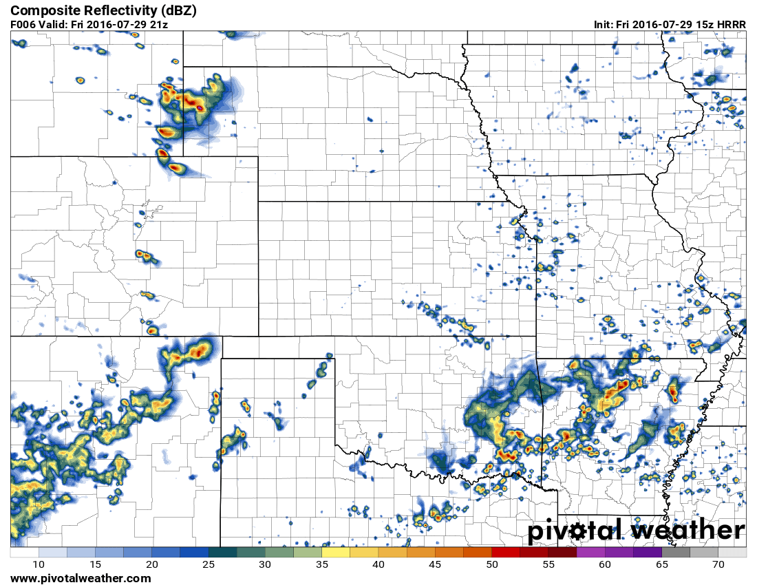
3PM HRRR model shows storms firing along the foothills mainly South of the Palmer Divide. Co Springs needs to keep a close eye out again today
I’ll be keeping an eye on the radar this afternoon and be sure to pass along any severe weather info or updates to the forecast when I can. Stay aware and happy Friday!

