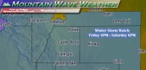
***Winter Storm Watch In Effect***
Locations Included:
Larimer and Boulder Counties Between 6000 and 9000 Feet- Jefferson and West Douglas Counties Above 6000 Feet/Gilpin/Clear Creek/Northeast Park Counties Below 9000 Feet- Elbert/Central and East Douglas Counties Above 6000 Feet-
Including the cities of Estes Park, Glendevey, Nederland, Red Feather Lakes, Bailey, Central City, Evergreen, Georgetown, Idaho Springs, Westcreek, Castle Rock, Elbert, Fondis, Kiowa, and Larkspur
Timing:
6PM MDT Friday April 28, 2017 through 6PM MDT Saturday April 29, 2017
Preparedness Actions:
A Winter Storm Watch means there is a potential for significant snow accumulations that may impact travel. Continue to monitor the latest forecasts.
–Full Winter Storm Watch Details–
Latest Forecast and Impacts
As there is still considerable uncertainty on storm track and intensity, this forecast WILL continue to change through the day Thursday and Friday. Stay tuned on Mountain Wave Weather for continued updates!
Timing
- Showers will likely begin after 2-3PM on Friday afternoon. Thunderstorms will be possible
- According to model guidance, heaviest snow looks to fall in the Friday evening hours, overnight Friday and through mid-day Saturday
- Temperatures will drop through the day Friday and end up in the mid to lower 20’s late Friday night into Saturday morning. Temperatures this cold will promote snow accumulation.
- Snow looks to come to an end by noon on Saturday with clearing conditions.
Precipitation Accumulations
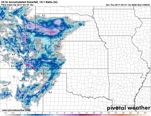
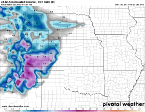
- Castle Rock and Northern Palmer Divide: Early snowfall estimates are in the 4-8 inch range for storm total accumulation
- Castle Rock, Pinery, Franktown, Elizabeth, Kiowa
- Areas over and near Monument hill will see slightly higher snowfall accumulation likely in the 5-10 inch range
- Larkspur, Palmer Lake, Monument, Black Forest
Why are our snow totals so much lower than local TV News and National Weather Service? With the data and trends we are seeing, we expect to see their forecast snowfall totals drop over the next 24 hours…
Wind/Visibility
- With the storm passage breezy Northwest winds in the 10-20mph range are expected
- Wind combined with falling snow will make visibility low in wind prone areas as the heavier snow is falling
Impacts
- With current modeling guidance, there is a POTENTIAL for significant snowfall amounts to impact travel, mainly for areas South of Denver.
- Expect slushy and snowpacked roads to cause travel issues in the areas between Denver and Colorado Springs
- Hard Freeze is expected Saturday night and Sunday night; this will lead to damage to sensitive vegetation and unprotected above ground sprinkler systems.
Analysis
The National Weather Service has issued a Winter Storm WATCH, which means conditions for a significant winter storm are POSSIBLE. By no means is this storm a done deal, in fact there are a few things that are giving me pause…
Model Uncertainty Remains High!
Models are still jumping around a major storm and a non-event for this storm system. I suspect that this is due to how difficult these spring storm systems are to forecast, but if we throw out the models and look at the pure meteorology, I’m not sold on a major snow producer out of this storm just yet.
Same Southward Jog
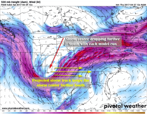
As we continue to get more model data in throughout the day we’re noticing a very familiar trend. Most models are showing a southern bias to the storm system… this is exactly what happened with the past 3 storm systems that hit our area. If you recall, they were all projected to drop major snow all the way until the last minute but then, took a quick jump to a non-event.
This storm system is showing similar tendencies, and while no two storm systems are the same, we can’t help but notice this trend. It will need close watching over the next 24 hours to see if we see the models significantly scale back snowfall.
Summary
At this point in time, the models are still holding on to a decent sized storm out of this but I’m not sold just yet. We’ve seen scenarios too many times like this in the past month or two that don’t pan out and the pure meteorology doesn’t support a big storm with this just yet. Can things change? Absolutely, forecasting this time of year is very fluid so expect our forecast and event the National Weather Service’s forecast to change in the next 24 hours.
My Advice?
- Be prepared for bad weather Friday night into Saturday morning, mainly travel difficulties South of Denver.
- Significant snowfall is POSSIBLE but not set in stone just yet. Just be aware that we may or may not see big snowfall accumulation with this storm.
- If the snow does materialize it will be heavy and wet; expect damage to tree branches and power lines
- The cold will be the big story here! Damage to sensitive vegetation and sprinkler systems is likely Saturday and Sunday night. Drain your irrigation systems or cover the pipes and cover sensitive plants.
Stay tuned for latest updates on this forecast on our site and Facebook page!
Thank you for following along and for all the support!


