Understanding SPC Severe Thunderstorm Risk Categories
What You Need to Know About SPC Severe Storm Risk Categories
What Makes a Thunderstorm “Severe”?
Not all thunderstorms are created equal. While many produce lightning and brief downpours, severe thunderstorms meet specific criteria that make them capable of causing damage and posing a real threat to life and property.
According to the National Weather Service, a thunderstorm is classified as severe if it produces any of the following:
-
Hail at least 1 inch in diameter (about the size of a quarter)
-
Wind gusts of 58 mph or higher
-
A tornado, or strong rotation in the storm that could lead to one
These thresholds aren’t random—they’re based on what typically starts to cause problems. Hail that size can dent vehicles, break windows, and damage crops. Winds over 58 mph are strong enough to knock down tree limbs, damage roofs, and make driving hazardous, especially for high-profile vehicles.
🌪️ Tornadoes—even brief or weak ones—automatically make a storm severe. Sometimes, strong rotation is visible on radar or even in the cloud base before a tornado actually forms. These are the storms we monitor most closely, especially during spring and early summer here along the Palmer Divide and out across the plains.
It’s worth noting that lightning and heavy rain alone don’t make a storm “severe”—though they can still be dangerous. Flash flooding, for instance, is tracked through different alerts like Flood Advisories or Flash Flood Warnings.
How Different SPC Severe Storm Categories Look and What They Mean
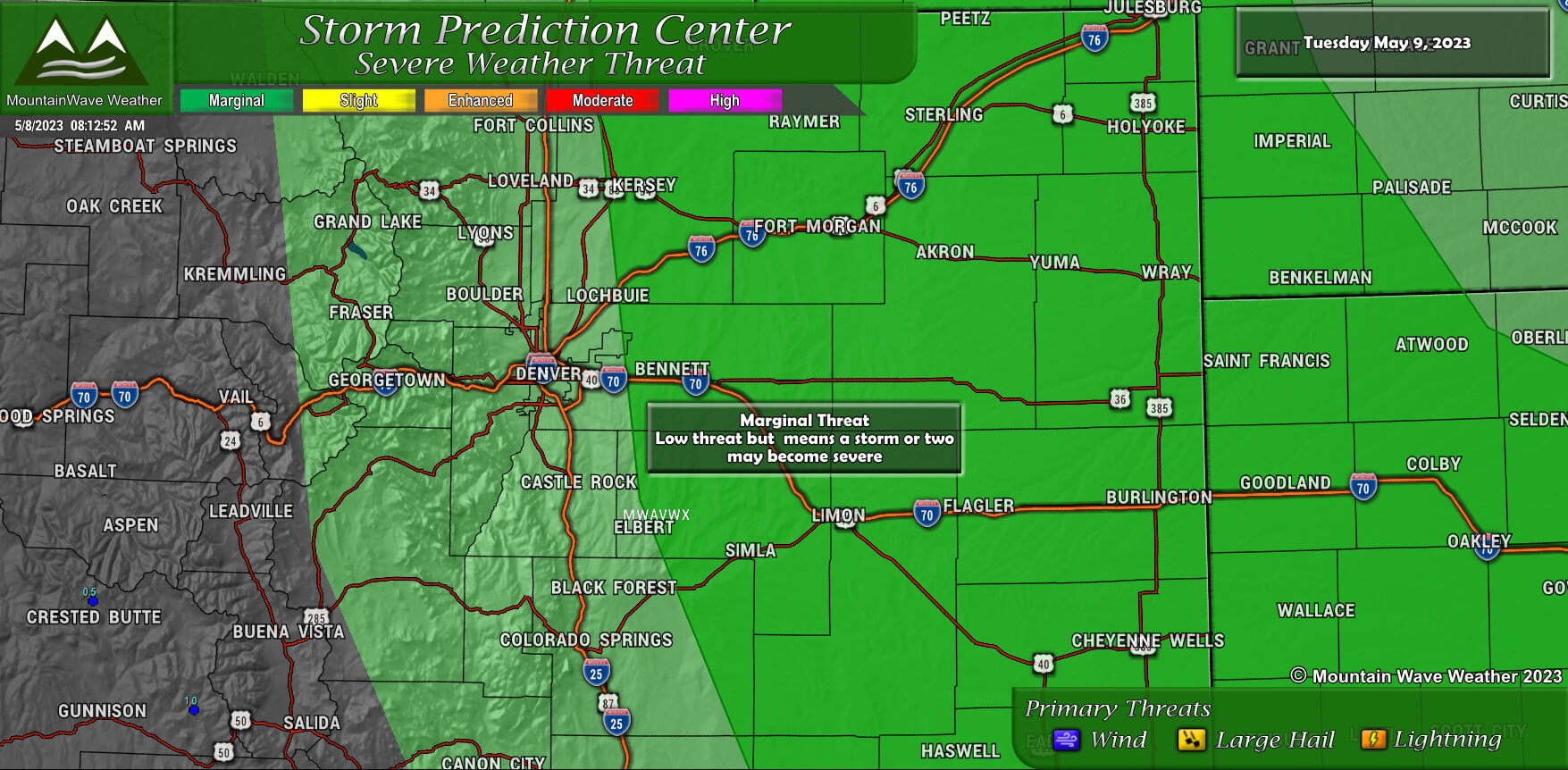
What Does a Marginal Risk Mean?
A few storms could get strong—but most won’t.
This is the lowest level (1 out of 5) on their severe weather outlook scale. It means that severe storms aren’t expected to be widespread, but an isolated storm or two could reach severe levels if the setup comes together just right.
🌦️ What you can expect on a Marginal Risk day:
-
Storm coverage will be hit or miss—many areas may stay dry or only see general thunderstorms.
-
Any stronger storms that do develop will likely be brief and localized, rather than part of a large, organized system.
-
These setups are usually more conditional, meaning the atmosphere might be just unstable enough, or just moist enough—but it’s not a slam dunk.
Here in Colorado, Marginal Risk days are common in spring and summer—especially along the Palmer Divide, Front Range Foothills, and eastern plains, where terrain and elevation can locally enhance storm development.
💡 Bottom line:
Marginal Risk doesn’t mean “nothing will happen,” but it does mean that most of us won’t see significant storms. Still, it’s smart to stay weather-aware, especially during the afternoon and evening when storms are most likely to fire up.
What Does a Slight Risk Mean?
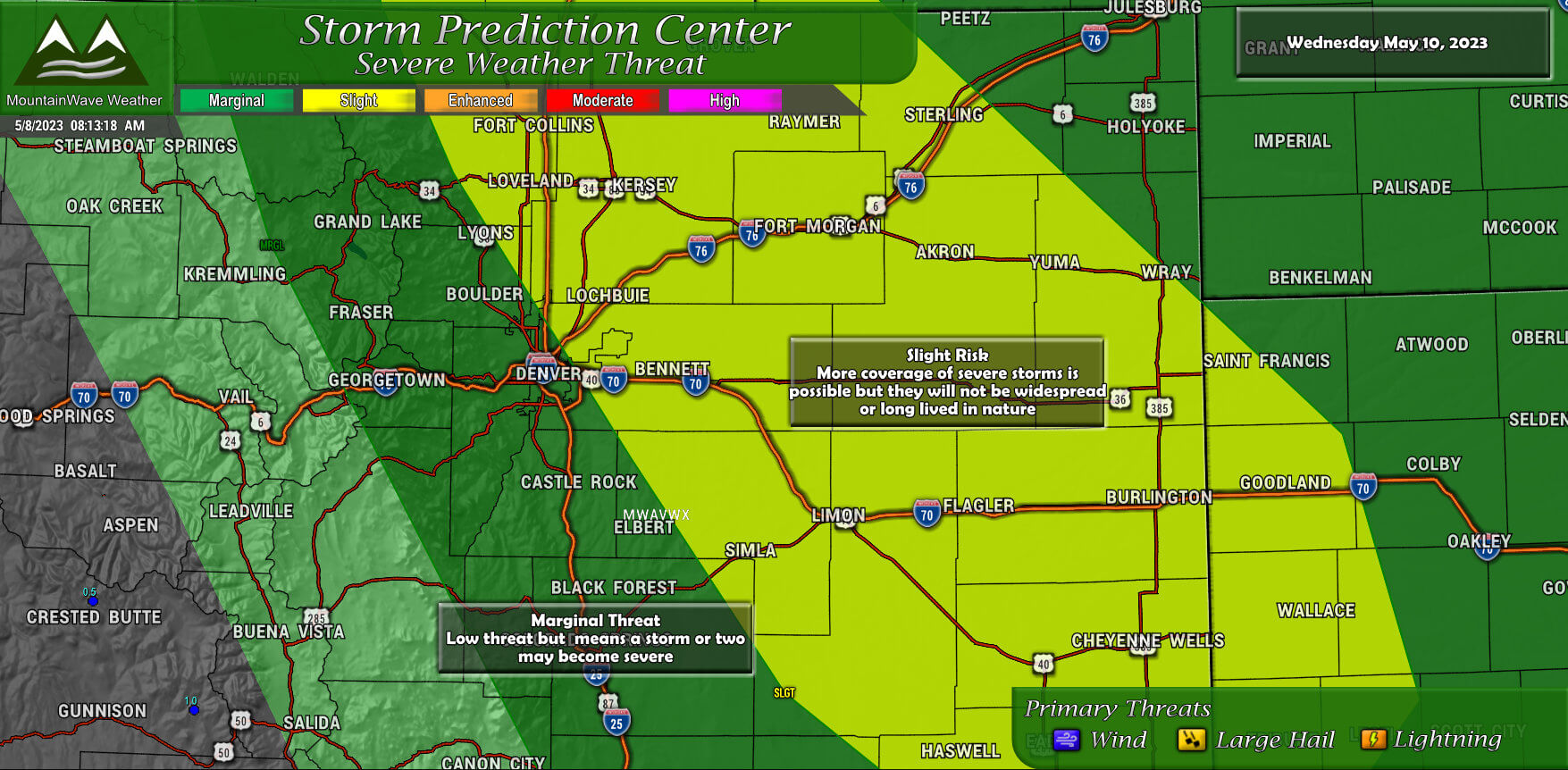
A Slight Risk is level 2 out of 5 on the Storm Prediction Center’s severe weather outlook scale. It means there’s a better chance of seeing a few organized severe storms, and those storms may pack more of a punch compared to lower-risk days.
This doesn’t mean a severe outbreak is expected—but it does mean confidence is higher that at least some areas will see storms capable of causing damage.
🌩️ On a Slight Risk day, you can expect:
-
More widespread storm development—severe storms may affect a broader area instead of being isolated.
-
A few of the storms may be stronger and longer-lived, possibly forming small clusters or short-lived lines.
-
Storms will still be scattered, but they’ll be more impactful where they do hit.
Here along the Front Range, Palmer Divide, and across the Eastern Plains, Slight Risk days tend to pop up during peak storm season—especially when we’ve got more moisture, instability, and wind shear in place. These are the days where we keep a closer eye on radar for storm strengthening and possible warnings, particularly later in the day.
💡 Bottom line:
A Slight Risk means the potential for a few more severe storms, with higher confidence in their development. Most folks might still avoid the worst of it—but the storms that do develop have a greater chance of becoming significant.
What Does an Enhanced Risk Mean?
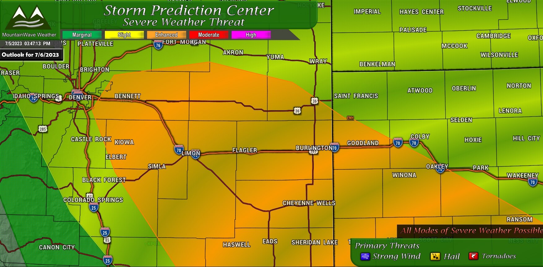
An Enhanced Risk is level 3 out of 5 on the Storm Prediction Center’s scale—and this is where things start to get more serious. It signals a greater likelihood of numerous severe storms, with a few potentially more intense or higher-impact events.
This doesn’t mean a widespread outbreak is guaranteed—but it does mean confidence is growing that multiple storms will reach severe levels, and that some could be significant.
🌩️ What to expect on an Enhanced Risk day:
-
Storms are usually more numerous and better organized, often forming clusters or lines.
-
There’s a greater chance for storms to produce more intense impacts, especially with higher moisture and instability in place.
-
Storm coverage may be more widespread, meaning more communities could be affected.
In Colorado, Enhanced Risk setups are less common but not rare—especially during active late spring or early summer patterns. These are the days when we often have a stronger upper-level system moving through, or a well-defined surface boundary that helps trigger and sustain storms across areas like the Palmer Divide, I-25 corridor, and Eastern Plains.
🟠 Bottom line:
An Enhanced Risk means we’re more likely to see several severe storms, and some may bring damaging wind, large hail, or even a tornado or two. These are high-impact weather days, and it’s important to stay weather-aware and have a way to receive warnings.
What Does a Moderate Risk Mean?
A Moderate Risk is level 4 out of 5 on the Storm Prediction Center’s scale, and it’s reserved for days when a serious and more widespread severe weather event is likely.
This kind of outlook doesn’t happen often—especially here in Colorado—but when it does, it’s a strong signal that multiple storms could produce dangerous and damaging weather over a larger area.
🌪️ What to expect on a Moderate Risk day:
-
Severe storms are expected to be widespread, intense, and more long-lasting than lower-risk days.
-
The environment is usually very favorable for organized, high-impact storms, including squall lines or supercells.
-
There’s a higher chance of significant impacts, like large areas of damaging winds, very large hail, or stronger tornadoes.
Here along the Front Range, Palmer Divide, and out across the Eastern Plains, Moderate Risk days are relatively rare, but they do happen—usually when we have a classic severe weather setup with abundant moisture, strong wind shear, and a well-timed trigger like a dryline or strong cold front. These are the days when storm chasers head east, and when we’re especially vigilant about rapidly changing storm conditions.
🔴 Bottom line:
A Moderate Risk day means a higher confidence in dangerous, widespread severe storms. If you’re in one of these outlook areas, it’s a day to stay alert, review your severe weather safety plan, and be ready to act quickly if warnings are issued.
What Does a High Risk Mean?
A High Risk is level 5 out of 5 on the Storm Prediction Center’s severe weather outlook scale—and it’s reserved for the most dangerous and high-impact severe weather setups.
This is very rare, especially in Colorado. High Risk areas are most often issued in parts of the Central and Southern Plains, the Midwest, or the Deep South—usually during major tornado outbreaks or widespread, destructive wind events known as derechos.
🌪️ On a High Risk day, you can expect:
-
Widespread, intense, and life-threatening storms, often producing large tornadoes, destructive winds, or giant hail
-
Very high confidence from forecasters that a major severe weather outbreak is unfolding
-
Storms may be long-lived and fast-moving, with multiple rounds possible
If a High Risk ever includes parts of Colorado—especially the Eastern Plains—it’s an all-hands-on-deck situation. These are the days when storm preparedness becomes critical, and rapid response to warnings is essential.
🚨 Bottom line:
A High Risk means the atmosphere is primed for a major, dangerous severe weather event, and the odds of widespread, damaging storms are extremely high. If you’re in or near a High Risk area, pay close attention to updates, make sure weather alerts are enabled, and have a plan ready to go—especially if you’re in a mobile home or traveling.
More Information
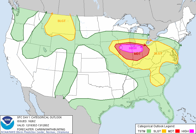
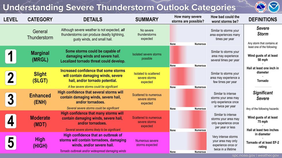
Here’s some additional information from the Storm Prediction Center summing up our discussion above.
Want to Know More? Check Out These Related Articles!

About the Author
Meteorologist John Braddock
Position
