To many, this year brings thoughts of windy days, heavy snowstorms, hail, tornadoes and heavy rain. We saw some hot days and some extremely cold days. One might say, "it was another wild and whacky year for Colorado weather." Indeed, there was quite a bit going on this year; we started the year with a moderate El Nino that transitioned into a strong El Nino by late summer. Intense riding to the west blocked and all but shut off our monsoon in July and August, not to say we didn't see wet periods throughout the year though.
There is no doubt that one of our biggest drivers for Colorado's weather this year was El Nino. As a large pool of warm water developed off the coast of California, it blocked storms from moving into Colorado. As this feature began to break down, more storms began to invade the state, especially into fall and early winter. While no two El Nino's ever produce the exact same results in Colorado, we can look at history and detect patterns. These patterns are never guaranteed to play out, but simply are more likely to occur based on history.
El Nino's affect on precipitation along the front range generally looks like this:
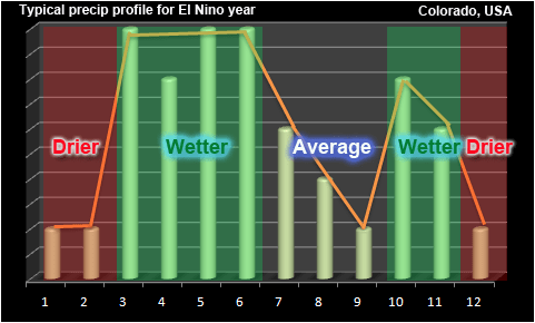
The pattern that commonly manifests with an El Nino is a drier winter period, a much wetter than average spring, an average to below average summer, followed by a wetter than average fall before transitioning into a drier winter pattern again.
When you take a look at how we finished in Castle Rock this year we see some similarities:
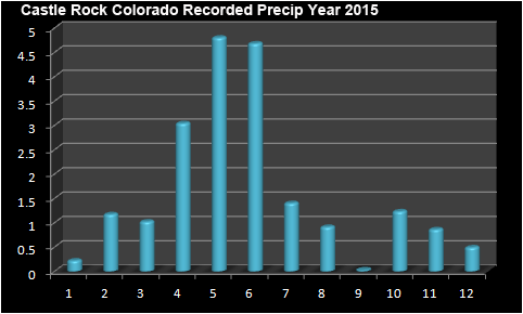
You see a drier start to the year in January, followed by a wetter than normal February. As we transition into spring, April through June became very wet with higher than average precipitation recorded. We are then followed by a lull into summer and early fall, mainly due to the blocking pattern that established over the western U.S. October ended above normal even though it all fell as rain and no snowfall was recorded. November and December, typically drier months also finished above average.
Looking at a comparison of the average precipitation profile vs. what I actually recorded you get this:
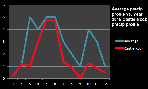
The red line (Castle Rock data) doesn't match the expect pattern exactly, but you can see that it is close for many months of the year. The only notable exceptions was the later start to the wet period in the spring and the much drier than normal summer.
Temperature patterns are a bit harder to nail down when it comes to El Nino years. The most common setup we look for is a warmer than average winter period followed by a cooler spring. Summer tends to be near average and as we transition back into fall we expect warmer than normal temperatures again.
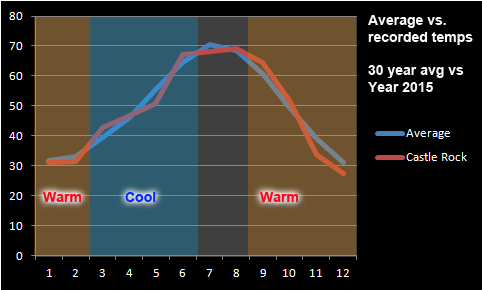
The red line is Castle Rock again, you can see while it generally follows the pattern the notable differences are there just as in precipitation. I think there are more differences here; noticing a below average winter to start 2015 and the cooler than average spring seems normal. Once you make it to summer the temperatures remained cooler than average, again not atypical as summer time temperatures can swing either way. El Nino's affects are generally felt less in summer and more in winter. The fall for 2015 was warmer than average as expected, however the winter to finish out 2015 was much cooler than average.
Summary
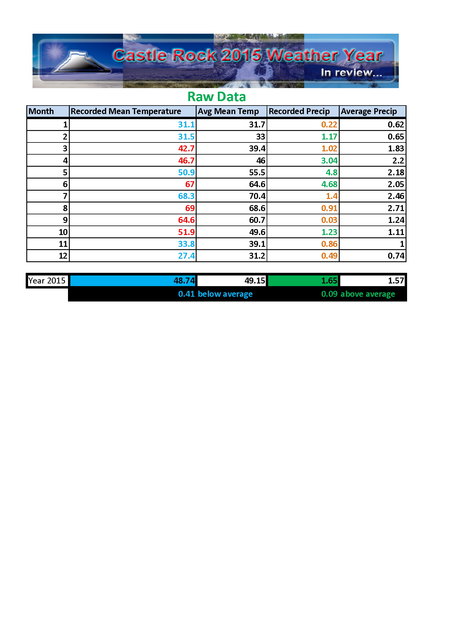
Raw data spreadsheet compiled from our weather station
Verdict: 2015 was slightly cooler than average and wetter than average for the Weather Year 2015.
2015 in many ways was a "typical" El Nino year for Colorado. We had a cooler and wetter than normal spring, with slightly below normal temperature and precipitation during summer. As we transitioned into fall it became warmer and wetter followed by an unusually cooler than normal winter period with above average precipitation.
Colorado's weather is a treat to watch and study, no two years are ever the same and regardless of the weather pattern. This year's El Nino behaved for the most part exactly how we would expect for many areas along the front range including Castle Rock and while the El Nino peaked in October, we will still feel its effects probably into late spring or early summer.
2016 Sneak Peak
The first half of 2016 will most likely be impacted quite a bit by El Nino. I would expect it to remain wet through late spring with below average temperatures in spring. As we reach towards summer our pattern may transition back to a more neutral state which would mean I would expect our monsoon to re-establish making August wetter than normal.
The big question will be the fall and winter. Super long range climate forecasting is not my strength but from what I've seen on some of the longer range stuff, we could be returning to a La Nina pattern by late next year into 2017. The typical pattern seen with this setup is generally a very dry period of time. Some of our worst droughts in the past 10-15 years have come from La Nina's following an El Nino event.
Many folks will want to keep this in mind as we move into late 2016 and early 2017. Our period of wetter months may come to an end and we could see a return to drought conditions in 2017.
