November 2025 Outlook – First Half
Any Snow in the Forecast? Recaping October 2025 and Scoping out the first half of November 2025
Quick October 2025 Recap and Continuing Weather Pattern
For most of Colorado, we didn’t see a whole lot of moisture in the month of October and areas in and around Denver recorded no snowfall accumulation.
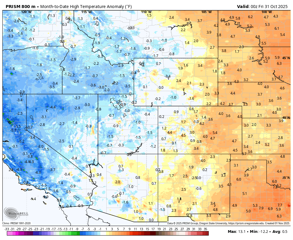
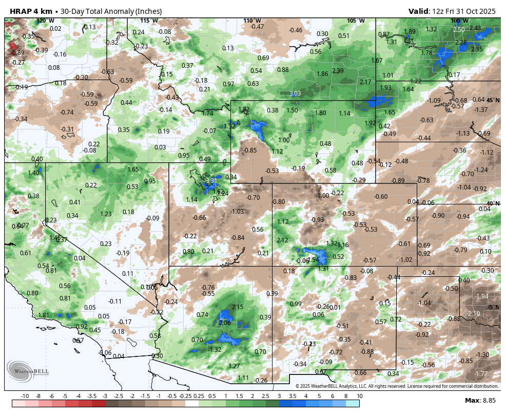
Here’s a quick look at where the Western U.S finished October 2025 in terms of temperature and precipitation departure from average.
Quick State Highlights
Northwestern Colorado
-
Overall dry
- Temperatures close to average, some pockets of slightly above
Southwestern Colorado
-
Benefited from moisture from hurricanes in the Pacific, most areas ended up above average for the month
-
Temperatures overall fairly close to normal, with pockets of slightly above average
Eastern colorado
-
Overall, Eastern Colorado and the Front Range were drier than average
-
Temperatures were well above average, with many places seeing 3-5 degrees above the 30-year average.
Colorado November 2025 – First Half of the Month Setup and Outlook
The first half of November looks a lot like how much of October went, the overall pattern remains intact and will influence our weather for at least the first half of the month.
Let’s take a look at some models and graphics!
Euro Ensemble (500m heights) Upper Air Pattern
💡A note about ensembles and 500mb model charts
-
What’s an ensemble?
Instead of relying on a single forecast model run, ensembles use many slightly different versions of the same model to show a range of possible outcomes — helping us see trends and confidence in the forecast, not just one “answer.”
-
Why look at 500mb height charts?
These maps show the mid-level steering pattern of the atmosphere, basically the jet stream. They help us spot big-picture trends like ridges (warmer/drier) and troughs (colder/stormier) that drive our weather in Colorado.
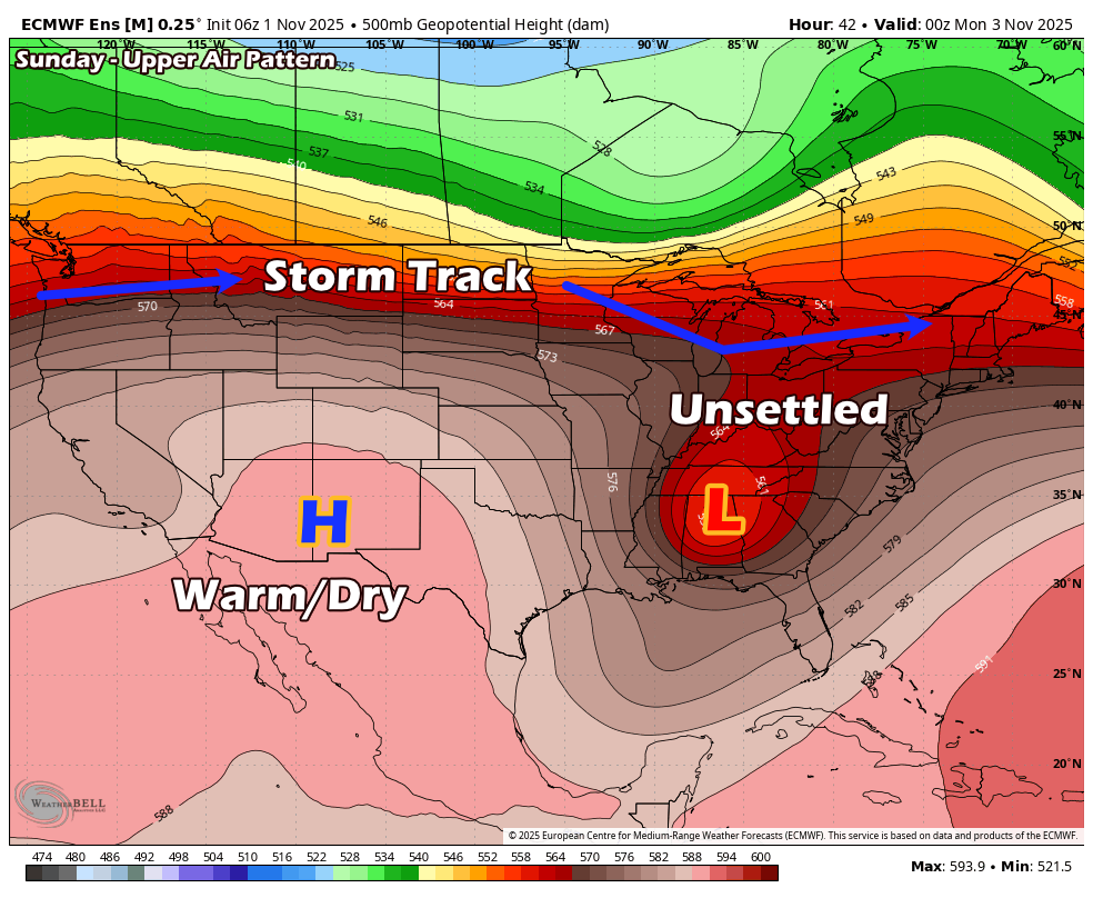
This Week through Wednesday
A few things to note about the setup this week:
- The jet stream is far to the North, this means any storms are being steered well North of Colorado.
- This allows a ridge of high pressure to build into the Southwest, which allows warm/dry/sinking air to dominate our weather pattern – none of this is good for snow chances
- Mountains may pick up smaller snowstorms, but with the main energy being North, we’re not expecting any “big dumps” up there with high snow accumulation
This pattern will start on Saturday and continue through the week. Because of the ridge to our South allowing warm, desert air to move into Colorado, along with the sinking (compressing/warming) nature of air under high-pressure ridges… Sunday may have close to record-breaking temperatures!
The Rest of the Week
Notice, as we jump to Wednesday, the similarities of the pattern hold on. As mentioned above, the norm will be warm/dry days, but with the ridge not quite as strong… our “warm” temperatures will be a bit more seasonal later in the week.
A Couple More Notes:
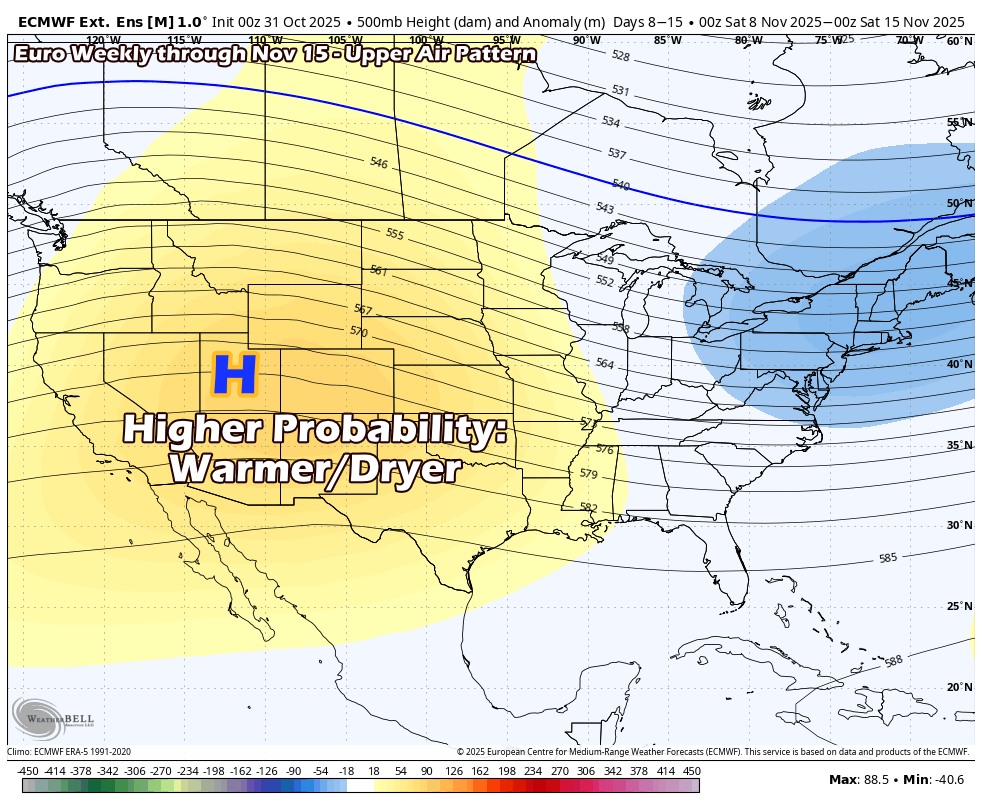
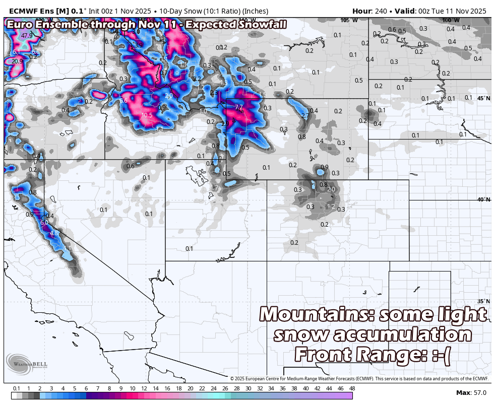
I’ve included graphics below from the Euro ensemble detailing the 500mb height anomaly through November 15 and expected snowfall through November 11.
This should give a pretty solid idea of where we’re leaning for the first half of November.
Just not really a lot of snow or storm systems to talk about.
What Could the Rest of November Hold?
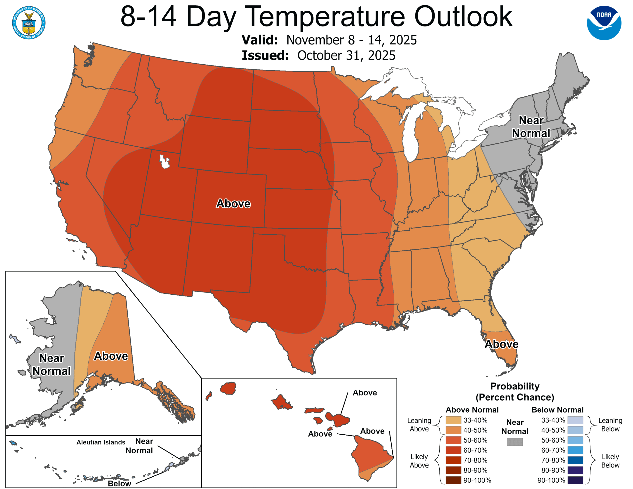
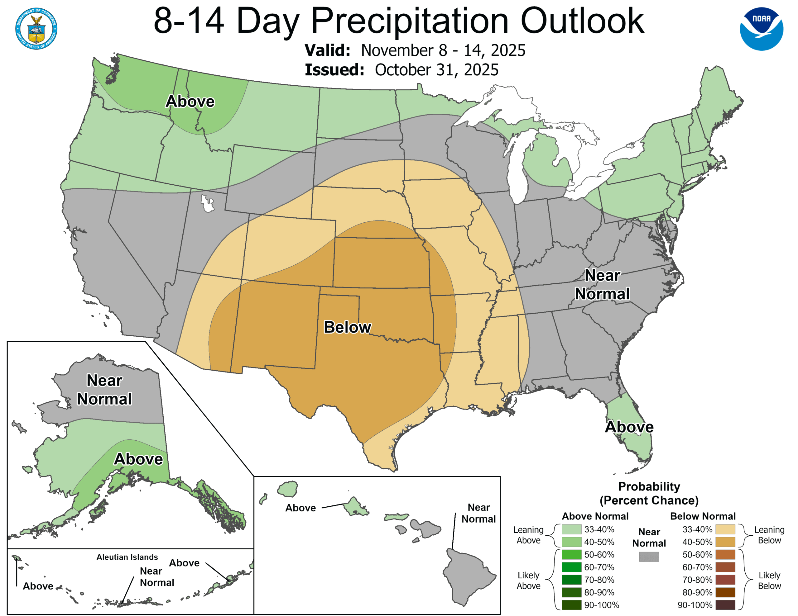
Below I have the CPC Graphics for the next 8-14 days, I won’t post the November monthly graphics because they pretty much look the same. The overall thinking from the CPC and many meteorologists (present company included) is that November has a higher probability to end up warmer and drier than average.
That doesn’t mean we don’t see any snow at all, it just means that when we end the month that whatever we’ve seen will likely below average.
Likewise with temperatures, it won’t be warm every day… but when we end the month and average it all out, we will likely be warmer than average.
Note About Longer Range Forecasts
As we get beyond about 10 days out, model skill drops significantly.
Don’t use outlooks like these to plan for something that far in the future (I can’t tell you if its going to snow 15 days from now on your ski vacation) but I can typically give you an idea of what the odds favor in that 15-30 day timeframe (read: what is more or less likely based on the pattern)
If you’re curious about more short-term forecasting for specific storms, those typically start showing up on Mountain Wave Weather around the 7-day mark.
Until then, we will keep our fingers crossed for some snow later this season, it’s definitely getting crispy out!
Want to Know More? Check Out These Related Articles!

About the Author
Meteorologist John Braddock
Position
