A Change in the Air – Forecast Outlook Week of Nov 17 2025
Weather To Expect This Week – Week of November 17, 2025
First Half: Windy and Warm Start
Monday: Upper low pushing east, winds and mountain snow picking up
The forecast is holding up pretty well so far today. A 500mb low is now pushing through southern Wyoming, which is right in line with expectations. We’re finally starting to see things ramp up a bit as it moves east.
Winds across the Front Range have been fairly tame this morning, but guidance still supports a steady increase through the afternoon. So far, mountain wave potential hasn’t really materialized and overall there’s nothing too crazy showing up just yet. We’ll keep an eye on how things evolve, especially near the foothills and usual wind-prone spots.
Mountain areas were mostly quiet overnight, but as that upper low tracks east, upslope (orographic) snow is expected to pick up again. Moisture and lift improve a bit with this positioning, so higher elevations should see snow coverage and intensity increase heading into midday and afternoon.
Nothing too crazy about the weather setup for Monday: strong upper support, improving flow, and just enough moisture to get things going, especially above 8,000 feet. Not expecting any major surprises, but localized impacts (slick roads, reduced visibility in snow bands) will still be possible in the mountains and passes as things develop.
We’ll keep watching for how the wind trends shape up along the I-25 corridor. Models have been a bit split on how much mixes down, so don’t hang your hat on gusts just yet, but it’s one to keep on the radar if you’re headed out this afternoon.
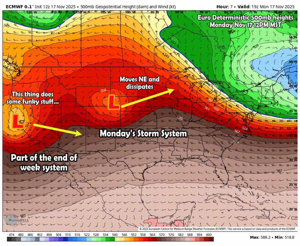
Below is a snapshot of the Euro deterministic at roughly 12PM MST today. It shows the low moving across Wyoming (again closed so cut off from the main branch of the jet stream) that will be responsible for that snow in the mountains and wind potential along the front range. That storm will move East through the day and dissipate.
I want to draw your attention to the West however, I’ve marked the secondary storm system expected to impact us later this week. Keep your eye on that one as I’ll talk about that a bit later in this post.
Second Half: Bigger Storm With a Messy Setup, Rain/Snow Possible? Lots of Uncertainty!
Thursday–Friday system has potential, but models still all over the place
Looking ahead to the latter half of the week, things get a bit more chaotic and our forecast confidence drops off a cliff. There’s a system in the works, but the exact details (track, timing, and how everything comes together) are still very much up in the air.
Right now, guidance is still struggling to resolve how this upper-level low interacts with the broader trough digging across the western U.S. Some ensemble members are kicking it quickly east as an open wave, others drop it south into Texas, and a handful of potentially more impactful solutions bring it east-northeast across northern New Mexico and into the Oklahoma Panhandle. That last group would favor more widespread precip, including the potential for snow down to the Denver metro… but those runs are still in the minority.
If that stronger, slightly more northern track were to verify, we’d likely be talking about more meaningful moisture and maybe some accumulation even at lower elevations. But right now that’s a big “if.”
The Euro ensemble spread shows about a third of members going that route, while around half suggest lighter precip and minimal snow, and the rest are mostly dry. GEFS is far less excited overall.
Bottom line:
-
There’s a storm signal, but it’s noisy
-
Precip is looking more likely than not, but the form (rain vs. snow) and where it sets up is still pretty murky
-
Lower elevations may just end up cold and damp, while the foothills and southern mountains could do better
-
If you’re hoping for a big Front Range snow, don’t hang your hat on it yet
We’ll keep tracking how this all shakes out over the next couple days. These types of setups; split flow, multiple pieces of energy trying to phase… tend to stay unsettled until we’re a lot closer.
So for now, just know something is likely coming, but don’t bank on details just yet.
Quick Glance: Weather Expected This Week
Monday November 17, 2025
Palmer Divide: mid to upper 50’s for highs, lows in the low 30’s.
Denver metro: upper 50’s for highs, lows in the mid 30’s.
Notable weather to watch for: High winds possible in the afternoon. Snow and travel difficulties for the mountains possible.
Tuesday November 18, 2025
Palmer Divide: upper 50’s for highs, lows in the low 30’s.
Denver metro: mid 60’s for highs, lows in the mid 30’s.
Notable weather to watch for: Breezy winds possible (15-20mph gusts front range, 20-25mph in the mountains) – no major weather/travel hazards expected.
Wednesday November 19, 2025
Palmer Divide: low 60’s for highs, lows in the mid 30’s.
Denver metro: mid 60’s for highs, lows in the mid 30’s.
Notable weather to watch for: No major weather/travel hazards expected.
Thursday November 20, 2025
*Potential Storm System Impact*
Palmer Divide: mid 40’s for highs, lows in the low 30’s.
Denver metro: low 50’s for highs, lows in the mid 30’s.
Notable weather to watch for: No major weather/travel hazards expected at this time. Continue to monitor the forecast for any potential impacts due to an incoming storm system.
Friday November 21, 2025
*Potential Storm System Impact*
Palmer Divide: low 40’s for highs, lows in the mid 20’s.
Denver metro: mid 40’s for highs, lows in the upper 20’s.
Notable weather to watch for: No major weather/travel hazards expected at this time. Continue to monitor the forecast for any potential impacts due to an incoming storm system.
For the Weather Nerds: Additional Analysis
Let’s take a closer look at how models think our end of week storm system evolves. If you recall from the earlier image, I labeled that storm system with a tag, “this thing does some funky stuff”… that’s no lie. Models don’t fully agree on anything related to how this storm system evovles, tracks, where/how intense it gets, etc… All of these are super important to determine what we see in Colorado.
The orignal image posted above show the Euro Deterministic snapshot at 12PM on Monday with a single low moving ashore in California.
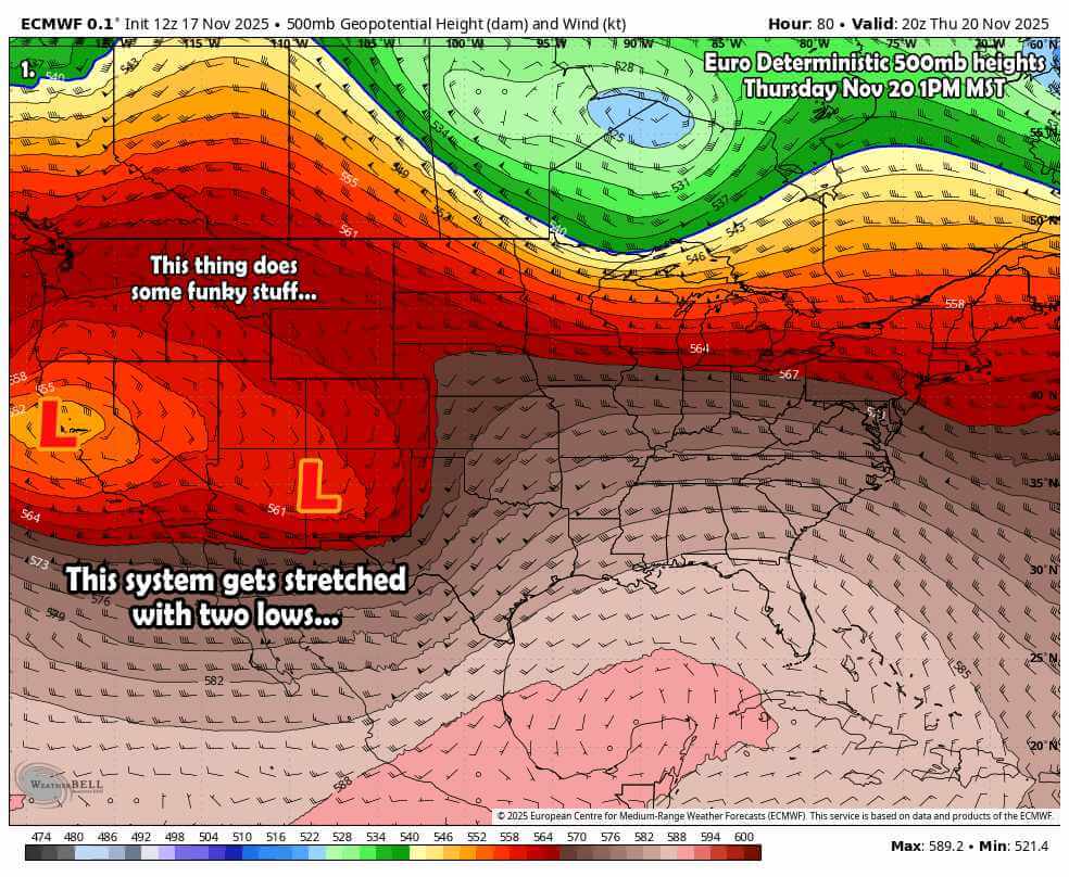
Let’s fastforward to later in the week: the image below is same model but on Thursday around mid-day.

As this system moves East towards the Rockies you see another low set up behind it. If we take the positioning of the orignal low at face value (tracking right across the four corner region) this setup looks quite favorable for a higher intensity storm and potential precipitation (myabe even snow) event for Colorado.
But here’s the problem, that low back to the West will “stretch the energy” and may actually end up weakening or dissipating the front low. It could also mess with its track or intensity.
See how that complicates things?
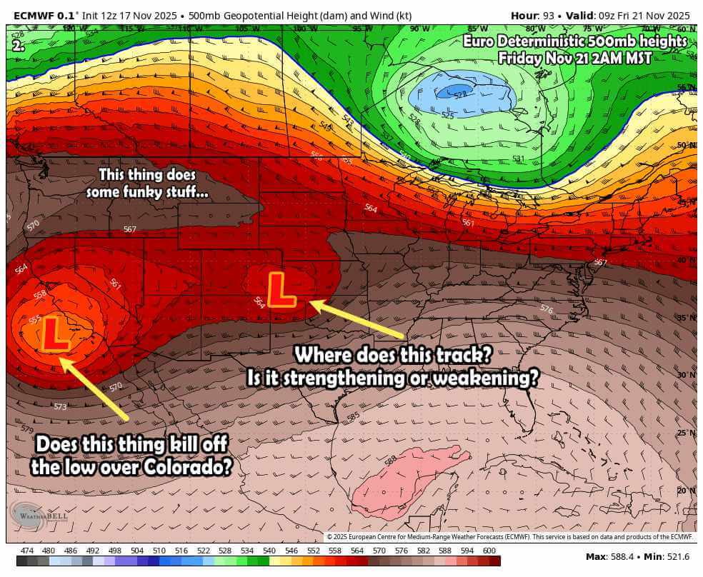
Let’s step forwards again, same model but this is 2AM Friday, again showing 500mb heights.

At this point the low to the West continues to strenthen while the low to the front takes that “favorable” track over Southeastern Colorado. If this were to materialize, we’d lean towards a sizeable upslope type precipitation storm system. Things like this look very favorable!
The concerning part here is the interaction with that trough (low) back to the West. Even though this particular model shows a favorable track for Eastern Colorado, many others do not. In fact, if you take the models we can look at and average their solutions out, we see something like this:
- 33% show a strong/wet upslope event for Eastern Colorado
- 33% show a weaker/light precipitation event for Eastern Colorado
- 33% show a non-event for precipitation for Eastern Colorado (area stays pretty dry)
The reason they are so split is because none of them can really figure out what that low to the West will do and how it will affect our low in Colorado.
If you asked me what I think or what my “gut feel” is on a storm like this… I lean towards a drier solution. I’ve seen a lot of storms like this in the past get “strectched out” where they have trouble maintaining intensity or tapping into cold air or get nudged too far North or South by that energy to the West.
My gut right now says I’d hedge on a lower impact solution. That being said, weather forecast evolves and so do my opinions based on the data coming in. That’s where I’m at right now with the data I have and the historical experience I bring (your weather app won’t give you any of this!)
What to Do? Time to Panic?
I’m not recommending any advanced preparation yet with this storm. No need to go out and start getting crazy with groceries or getting livestock ready (if you’re in the ag world.)
Right now we are in that “wait and see” part of the forecast.
My recommendation right now: keep checking back for updates and keep an eye on the forecast. I’ll keep you ahead of anything should things start to look more serious.
Want to Know More? Check Out These Related Articles!

About the Author
Meteorologist John Braddock
Position

