Mid to Late November Weather Pattern Change?
Keeping Our Eye on Next Weekend and Beyond
Despite What This Weekend’s Storm Does or Doesn’t Do… It May Be Hinting At a More Sustained Weather Pattern Change
This discussion will talk about what we’re looking at for this weekend’s storm, but also about what we see coming down the pipe in the days afterwards. This will be important because after the warm, dry and windy conditions we’ve seen for most of late summer and now well into fall… any chances of moisture are well needed and appreciated around here.
Here’s the first look at the upcoming setup for this weekend:
Mid/Upper Pattern Setup
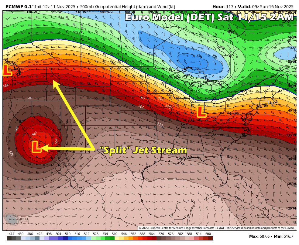
We see a “split” pattern in the jet stream as we move into Friday-Sunday. This shows up as a closed trough that breaks off and moves Eastwards across the Western U.S. while the main branch of energy stays to the North. I mentioned a bit about these yesterday in a social media post… but these types of setups dont’ typically favor Colorado a whole lot and especially don’t favor Eastern Colorado.
Here’s the problems we can see with these types of storm system:
- Storms like this can be moisture starved
- Storms like this can have issues with cold air advection
- Storms like this can have trouble maintaining strength
- Due to the complexity introduced in how these two features interact together (the cut-off low and main branch of the jet stream) models can have a really tough time determining where they track, how fast they move and how intense they can get.
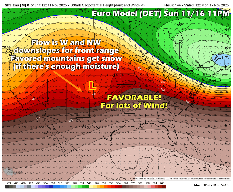
This is definitely the case here as we see the cut-off low merging back into the main branch of the jet stream immediately after it moves through Colorado. This does one major thing; it shifts this feature to the North meaning we see more of a Westerly or Northwesterly wind for the front rane (downsloping) and dries things out!
The Takeaway/ What to Expect
While any storm system can throw us a curveball, typically setups like this don’t do much for us, especially East of the Continental Divide… unless you like wind.
I will point out again; models are really struggling with the track/speed/intensity on this one. So anyone forecasting by using the models alone is probably more excited about this storm system, right? The models bounce back and forth to a favorable position.
The trick here is that when there’s this much uncertainty we rely on what we’ve seen more with these types of storms in the past. We can go back and look at similar setups and figure which outcomes are more likely.
With the data I’m seeing now and based on my forecasting process and what we’ve seen out of storms like this… if I were to take a stab at what we see (as of right now, remember forecasts are fluid)
- Colder temperatures likely, but wouldn’t say “that cold” as storms like this have trouble moving that colder air in from the North
- A small chance at showers for the front range, mainly later Saturday and into Sunday
- Snow chances are very small right now. 20-30% for up to .5 inches of accumulation but I’d expect the snow level to be relatively high – maybe 7,000-8,000 feet+
- Mountains have a better shot at snow. We will try determine how much, but I wouldn’t expect any big “power dumps” this weekend.
Preperation/Readyness Actions?
Right now, I’m not recommending any specific prep for this storm system other than just keeping an eye on the forecast.
Did You Know?
Here’s a quick look at one of the topics we are talking about with this weather discussion.
💡 All About Split Flow and Closed Lows
What’s a split flow?
Sometimes the jet stream splits into two branches with one staying up north, the other dropping south. That southern branch can carry moisture and energy into the Western U.S., often in a slower, more disorganized way.
What’s a closed low?
A closed low is a low-pressure system that’s completely cut off from the main jet stream. It tends to wobble around on its own tough to predict, but it can still bring rain or snow depending on where it tracks.
Why does it matter?
This week’s storm is riding the southern branch, totally disconnected from the main flow. It’ll rejoin the northern jet after it crosses Colorado and how quickly that happens will help decide how much moisture we get (or don’t). Historically when Colorado is caught between these two branches or flows of the jet stream, energy is pulled apart over the state… resulting in less lift and less energy available to any storms that move through.
Pattern Shifts into Next Week?
It’s easy to think we’ll slip past this storm with little impact and slide back into the same old pattern next week but there’s indications that the cooler/unsettled pattern may stick with us for a bit longer.
I’ve attached the Euro Ensemble below, this model shows about 50 solutions and averages their results out. The 500mb height anomoly graphic shows whether more members see high or low pressure as more likely in certain areas. You can see that the Southwest has lower heights (lower pressure) meaning we could see a period of more unsettled weather for a bit after this first attempt.
We can’t see any specific details on any storms right now, but I’d also be watching that Nov 19 timeframe for our next chance at stormy weather.
Waiting For Snow? Odds Are… We Will See “Some” Soon!
The good news with all of this is nearly every major model ensemble shows Eastern Colorado getting “some” amount of snow over the next 10 days. This would make sense climatologically, but also with these stormier setups we have on the horizon, I’d say our odds are decent to see something.
That being said, as of right now, I don’t see a liklihood of any major snow events or moderate/higher accumulation storms East of the Continental Divide just yet.
I’ll keep scanning for details, fingers crossed we start to see some moisture very soon!
Want to Know More? Check Out These Related Articles!

About the Author
Meteorologist John Braddock
Position


