Cloud Spotting Guide
Welcome to the Mountain Wave Weather Cloud Spotting Guide!
Curious About a Cloud You Saw?
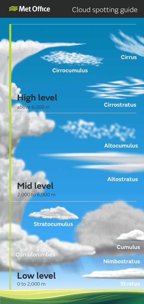
Our handy cloud graphic showcased below will help you figure out what type of cloud you are looking at and its elevation.

☁️ High-Level Clouds (Above 6,000 meters / 20,000 ft)
Cirrus (Ci)
-
Thin, wispy, and feather-like.
-
Made of ice crystals and usually found in fair weather.
-
Signal: Can indicate moisture aloft and sometimes hint at an approaching system, especially if thickening or lowering over time.
Cirrostratus (Cs)
-
Thin, veil-like clouds covering the sky, often causing halos around the sun or moon.
-
Signal: Often precedes a warm front or storm system within 12–24 hours.
Cirrocumulus (Cc)
-
Small, white patches or ripples. Often appear in rows and don’t cast shadows.
-
Signal: Rare in Colorado skies but can precede unsettled weather or a jet stream-related disturbance.
🌤️ Mid-Level Clouds (2,000–6,000 meters / ~6,500–20,000 ft)
Altostratus (As)
-
Gray or blue-gray sheets covering the sky, sun still dimly visible.
-
Signal: Often ahead of storms—especially winter snow or summer rain systems.
Altocumulus (Ac)
-
White or gray patches, often in rows or waves. Look like cotton balls with shading.
-
Signal: A warm, moist atmosphere aloft—could mean storms later in the day, especially in summer.
🌦️ Low-Level Clouds (Surface to 2,000 meters / ~6,500 ft)
Stratus (St)
-
Uniform gray layer, like fog that hasn’t reached the ground.
-
Signal: Light mist, drizzle, or just overcast skies—common with upslope flow in Colorado.
Stratocumulus (Sc)
-
Low, lumpy clouds, often in rows with breaks of blue sky.
-
Signal: Typically benign but can precede weakening systems or follow a cold front.
Cumulus (Cu)
-
Fluffy, white clouds with flat bases. Fair weather versions are short and scattered.
-
Signal: Generally a sign of good weather unless they grow taller (congestus).
Nimbostratus (Ns)
-
Thick, dark gray cloud layer bringing continuous rain or snow.
-
Signal: Long-lasting precipitation, usually tied to steady systems rather than convective storms.
Cumulonimbus (Cb)
-
Towering giants with anvil tops—classic thunderstorm clouds.
-
Signal: Lightning, hail, heavy rain, and potentially severe weather. The more vertical, the more dangerous.

🌄 Common Cloud Formations in Eastern Colorado
Eastern Colorado’s terrain and proximity to the Rockies make for some fascinating cloud setups. Here’s what to look for by season:
🌱 Spring
-
Altocumulus + Altostratus: Ahead of developing low-pressure systems—watch for rain or snow.
-
Cumulonimbus: Thunderstorm season starts. Hail and strong winds become a risk by May.
-
Stratus: Common with upslope flow from SE/E winds—leads to gray, cool days.
☀️ Summer
-
Cumulus → Cumulonimbus: Watch for these growing vertically by afternoon—classic thunderstorm development.
-
Cirrus ahead of storms: Sometimes you’ll see wispy cirrus in the morning, hinting at instability building for later.
-
Altocumulus castellanus (ACCAS): Sign of upper-level instability—often appears before afternoon thunderstorms.
🍂 Fall
-
Stratocumulus and Stratus: Return with shallow cold air intrusions.
-
Altostratus: Common ahead of early-season snow events.
-
Cirrus/Cirrostratus: Preceding Pacific systems riding along the jet stream.
❄️ Winter
-
Nimbostratus: Big player during snowstorms. Brings widespread, steady snow.
-
Stratus: Very common with upslope systems—classic fog and flurries along the Palmer Divide.
-
Altostratus: Appears before moisture-laden winter storms.
🏔️ Special Note: Palmer Divide Clouds
-
The Palmer Divide (elevations over 6,000 ft) can dramatically change cloud behavior.
-
Watch for Stratus and Fog forming early here during upslope events.
-
Cumulonimbus often fires along this boundary in summer thanks to convergence zones.
-
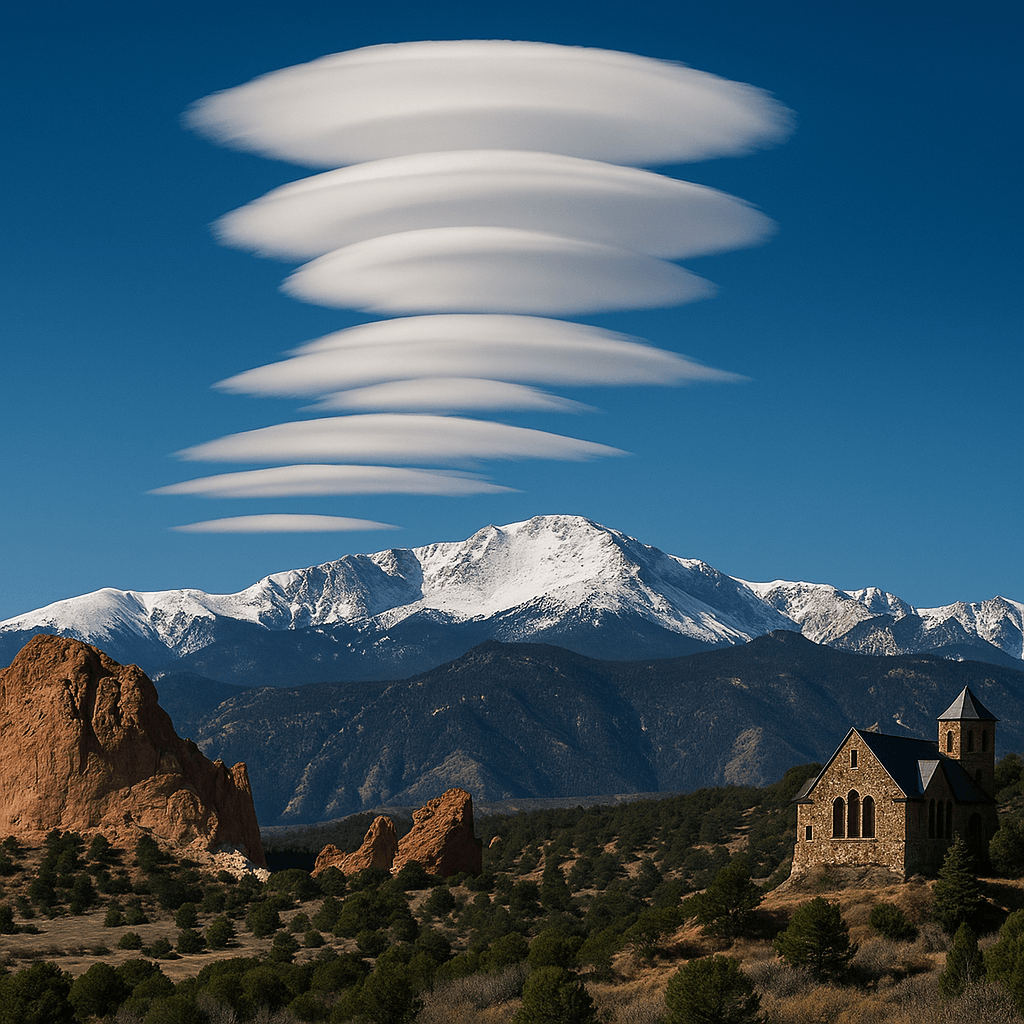
Lenticular clouds (not on the chart) sometimes form here too—smooth, lens-shaped clouds that indicate mountain wave activity.
Want to Know More? Check Out These Related Articles!

About the Author
Meteorologist John Braddock
Position
