Third Times the Charm? Snow Storm Forecast valid 12/2/2025
Been Waiting for a Decent Colorado Snow Storm? This Might Be Your Shot!
Valid 12/2/2025 6AM MST
Winter Weather Alerts Issued
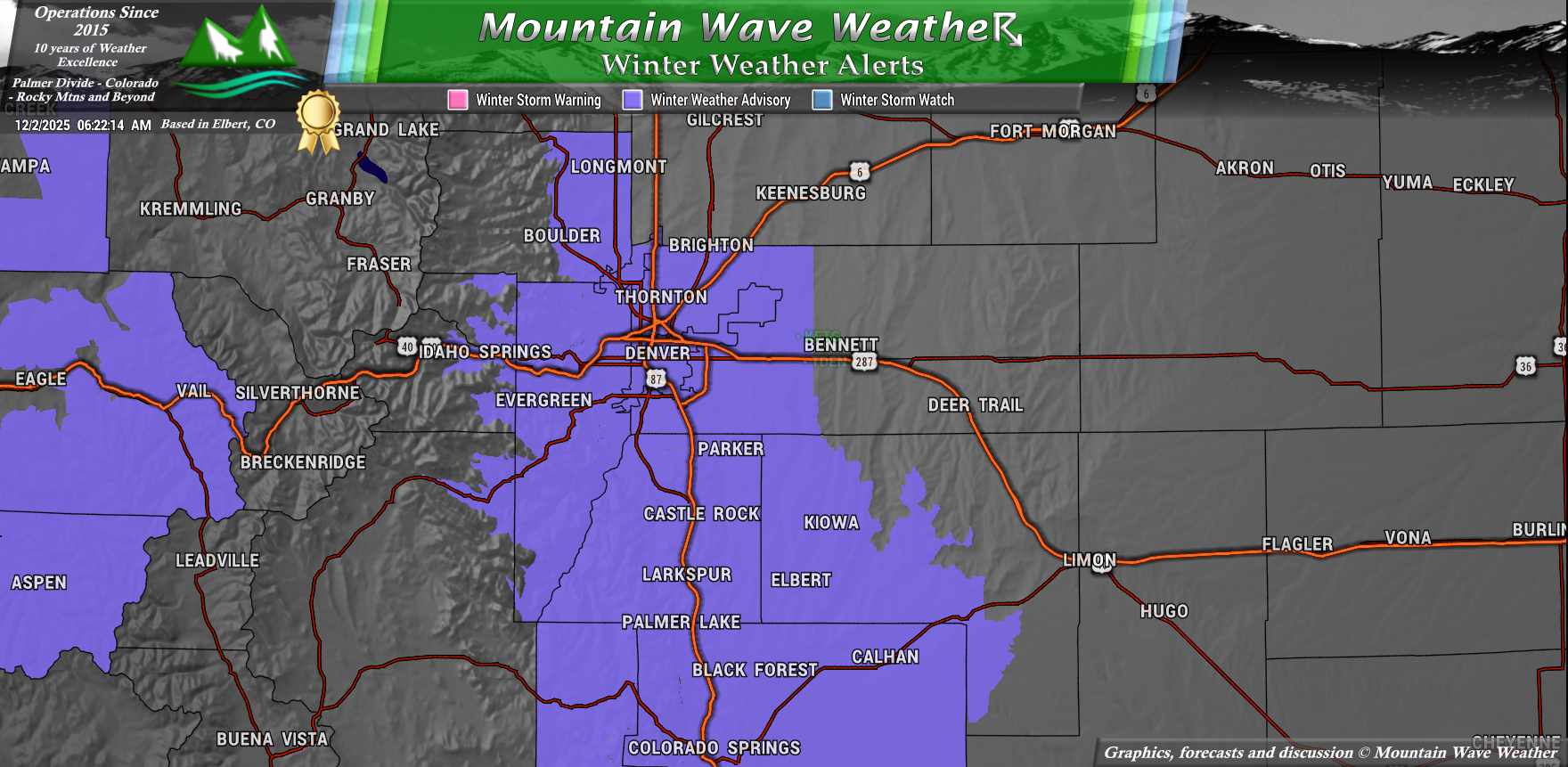
In advance of this week’s anticipated snow storm, Winter Weather alerts have been issued for the Front Range Foothills, Denver Metro Area and the Palmer Divide. Here’s the latest information:
Winter Weather Advisory issued December 2 at 2:53AM MST until December 3 at 6:00PM MST by NWS Denver CO
SEVERITY: Moderate
URGENCY: Expected
CERTAINTY: Likely
TIMING:
Begins: Wed Dec 03 12:00 AM UTC-07:00
Expires: Wed Dec 03 06:00 PM UTC-07:00
AFFECTED AREAS:
Boulder And Jefferson Counties Below 6000 Feet/West Broomfield County; North Douglas County Below 6000 Feet/Denver/West Adams and Arapahoe Counties/East Broomfield County; Elbert/Central and East Douglas Counties Above 6000 Feet
DESCRIPTION:
* WHAT…Snow expected. Total snow accumulations between 3 and 5
inches, with locally up to 6 inches at the base of the foothills.
* WHERE…Boulder and Denver metro areas, Castle Rock, and Palmer
Divide.
* WHEN…From midnight tonight to 6 PM MST Wednesday.
* IMPACTS…Plan on slippery road conditions and slow travel. The
hazardous conditions will impact the Wednesday morning commute,
with potential for slick roads to persist into the evening commute
as well.
Winter Weather Advisory issued December 2 at 2:53AM MST until December 3 at 6:00PM MST by NWS Denver CO
SEVERITY: Moderate
URGENCY: Expected
CERTAINTY: Likely
TIMING:
Begins: Wed Dec 03 12:00 AM UTC-07:00
Expires: Wed Dec 03 06:00 PM UTC-07:00
AFFECTED AREAS:
Jefferson and West Douglas Counties Above 6000 Feet/Gilpin/Clear Creek/Northeast Park Counties Below 9000 Feet
DESCRIPTION:
* WHAT…Snow expected. Total snow accumulations between 4 and 9
inches.
* WHERE…The Southern Front Range Foothills.
* WHEN…From midnight tonight to 6 PM MST Wednesday.
* IMPACTS…Travel could be difficult. The hazardous conditions will
impact the Wednesday morning and afternoon commutes.
Southern Colorado Winter Weather Alerts Issued
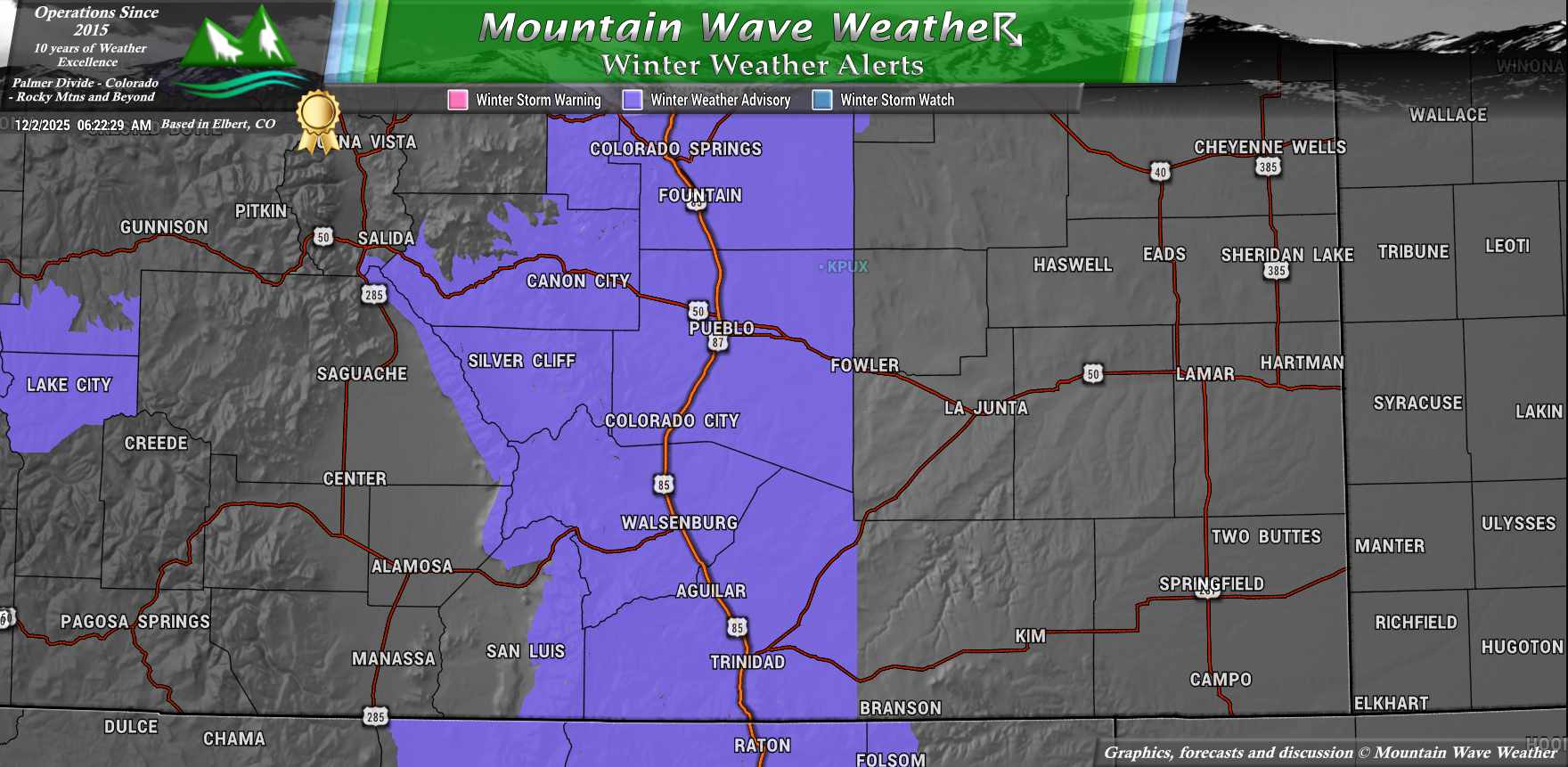
In addition to the weather alerts for Denver and surrounding areas, Southern Colorado also had Winter Weather Advisories issued for the Southern I-25 corridor including Colorado Springs, Pueblo, Colorado City, etc…
Here’s the information on those:
Winter Weather Advisory issued December 2 at 2:25AM MST until December 3 at 8:00PM MST by NWS Pueblo CO
SEVERITY: Moderate
URGENCY: Expected
CERTAINTY: Likely
TIMING:
Expires: Wed Dec 03 08:00 PM UTC-07:00
AFFECTED AREAS:
Western/Central Fremont County Below 8500 Ft; Canon City Vicinity/Eastern Fremont County; Colorado Springs Vicinity/Southern El Paso County/Rampart Range Below 7400 Ft; Pueblo Vicinity/Pueblo County Below 6300 Feet
DESCRIPTION:
* WHAT…Snow expected. Total snow accumulations between 2 and 5
inches with locally higher amounts possible.
* WHERE…Southern El Paso, Pueblo, Western and Central Fremont
County Below 8500 Feet, and Eastern Fremont County.
* WHEN…From 8 AM to 8 PM MST Wednesday.
* IMPACTS…Roads, and especially bridges and overpasses, will
likely become slick and hazardous. Plan on slippery road
conditions. The hazardous conditions could impact the Wednesday
evening commute.
PREPAREDNESS/INSTRUCTIONS:
Slow down and use caution while traveling. The latest road
conditions for the state you are calling from can be obtained by
calling 5 1 1.
—————————————-
Winter Weather Advisory issued December 2 at 2:25AM MST until December 3 at 8:00PM MST by NWS Pueblo CO
SEVERITY: Moderate
URGENCY: Expected
CERTAINTY: Likely
TIMING:
Expires: Wed Dec 03 08:00 AM UTC-07:00
AFFECTED AREAS:
Teller County/Rampart Range above 7500fT/Pike’s Peak Between 7500 And 11000 Ft; Pikes Peak above 11000 Ft; Northern El Paso County/Monument Ridge/Rampart Range Below 7500 Ft
DESCRIPTION:
* WHAT…Snow expected. Total snow accumulations between 3 and 6
inches with locally higher amounts across the higher terrain.
* WHERE…Teller County and the Rampart Range including Pikes Peak,
and Northern El Paso.
* WHEN…From 2 AM to 8 PM MST Wednesday.
* IMPACTS…Roads, and especially bridges and overpasses, will
likely become slick and hazardous. Travel could be very difficult.
The hazardous conditions could impact the Wednesday morning and
evening commutes.
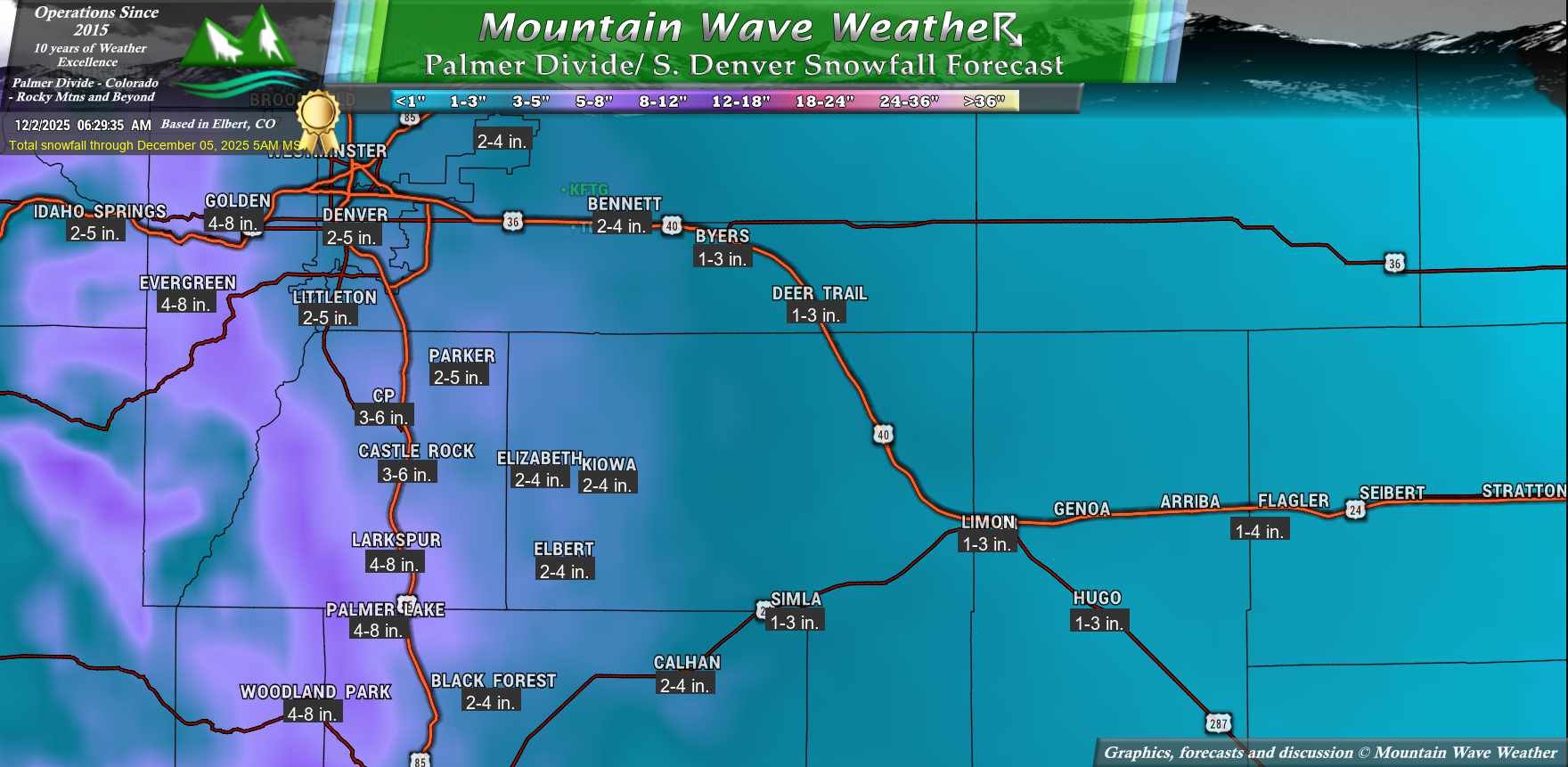
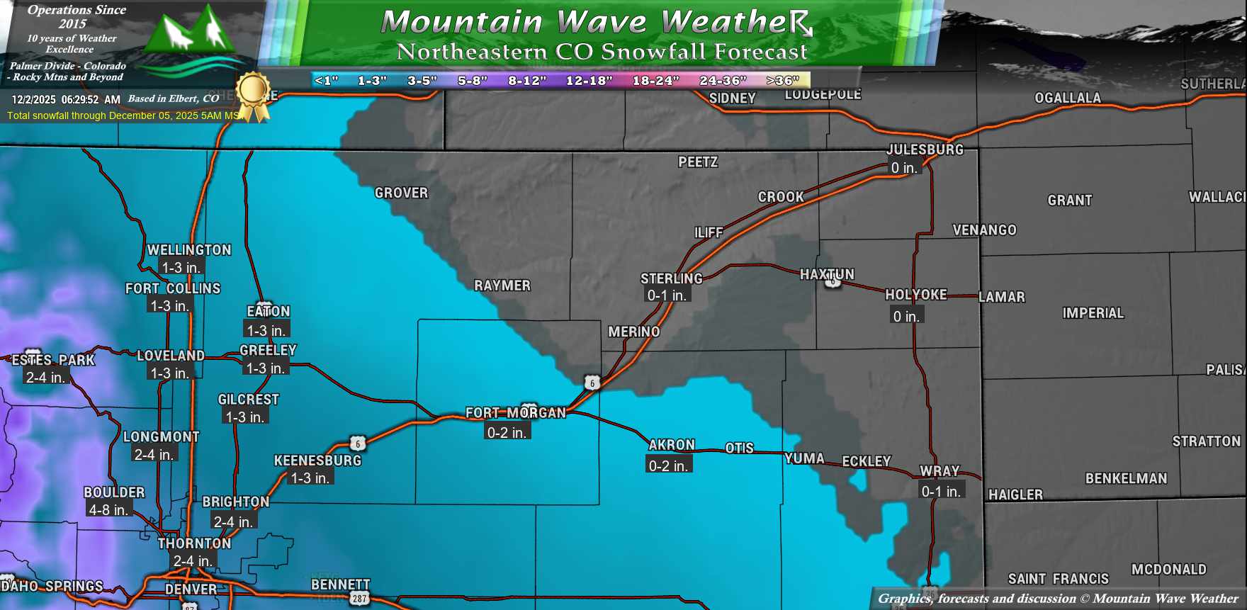
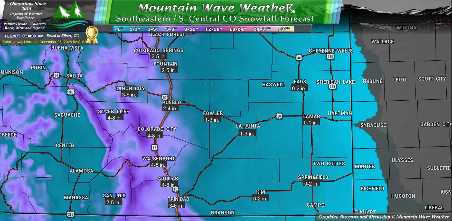
Snowfall Forecast through Saturday AM
Consider these amounts preliminary and the forecast will likely change through the day Tuesday as we get more data in. Keep checking back for updates!
Palmer Divide/ S. Denver
Upslope favored areas will do best with snow with this storm. With NE winds, expect the foothills to have the best chance with higher snow totals… if the winds are more Northerly… much of the Palmer Divide may hit those higher ranges.
Northeastern Colorado
Mainly a foothills event and metro Denver event for Northeastern Colorado. As you move further out on the plains, less snow and impacts expected.
Southeastern Colorado
The higher elevations in Southern Colorado will see the highest snow totals. The trek between Colorado City and over Raton Pass and into New Mexico could be particularly difficult. If you’re heading that way or West into the hills, stay alert and updated with road conditions.
Timing and Preparedness
Timing
Expect the highest impact on travel Wednesday morning. Travel impacts may linger into Wednesday evening as well.
Be prepared for slick roads, traffic and general travel difficulty.
Preparedness
Be ready for mainly impacts to travel and/or outdoor events. Snow and cold will make travel on the roads difficult. The potential exists for school delays and cancellations.
If you are traveling out of DIA prepare for some delays there too. Check with your airline before heading that way.
Final Thoughts
Moderate sized storm on the way with everything that comes with it.
Forecast information will be coming in today along with better models (shorter range/higher resolution) which should give us more of an idea on confidence, trends and if any changes need to be make to the forecast.
Be sure to keep a close eye on the forecast, I’ll post any changes on Facebook or here!
Want to Know More? Check Out These Related Articles!
About the Author
Meteorologist John Braddock
Position
