End of Week Storm – Forecast Update Nov 19 2025
End of Week Storm Update
Valid 11/19/2025 4PM MST
Things Becoming Clearer?
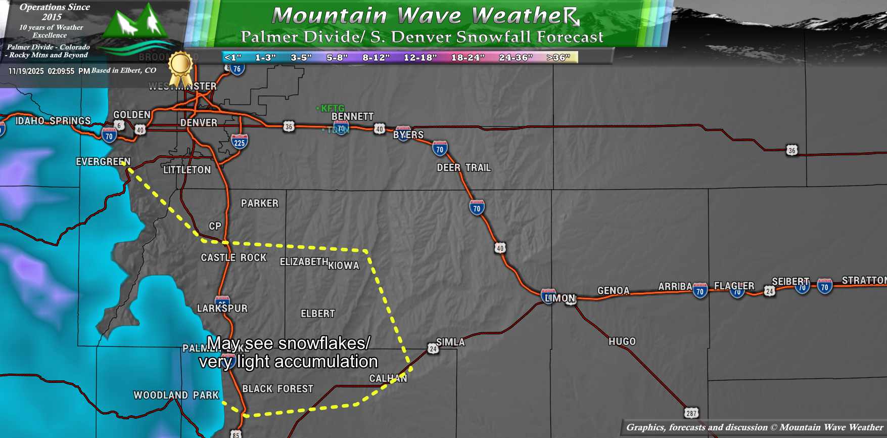
While there are still some moving parts of this forecast that remain tricky one, a few of them are becoming a bit clearer. One trend that has continued and a signal that has strengthened today is that we are no longer seeing chances for anything beyond a light snow event for the highest elevations along the Palmer Divide. This means if you’re below about 6,500 feet, you may see some flakes or very minur accumulations, but little beyond that. If you’re right on that line or below; this will likely be a rain event for you.
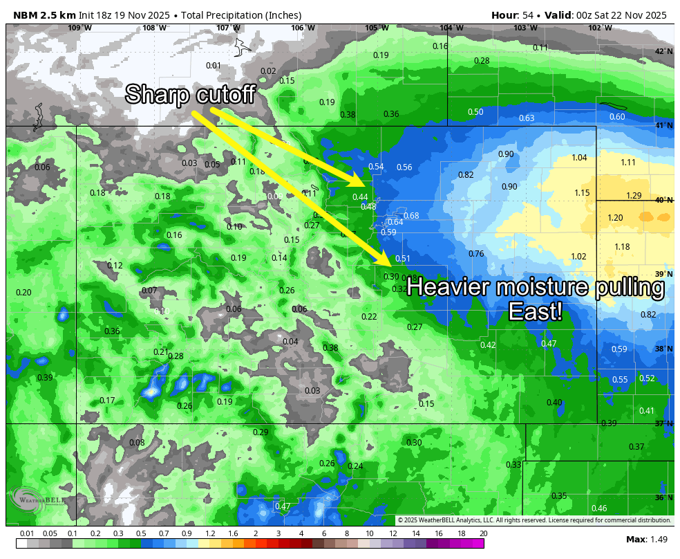
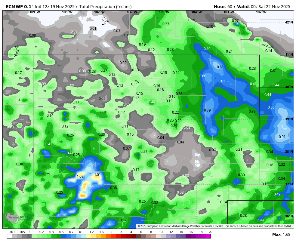
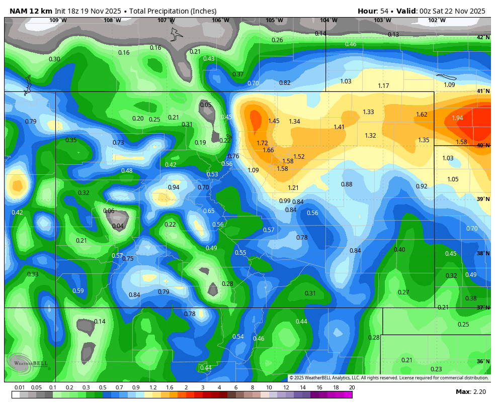
The good news is, regionwide we all have a pretty decent shot at moisture. Amounts are still to be determined, here’s the latest National Blend product with QPF (quantitative precipitation forecast, meaning if we took all of the moisture regardless of the form it falls in and add it up.)
One trend we’ve seen is the tendency for the heavier moisture to move further East. This is one we’ll have to watch, as it’s causing models to drop the amount of precipitation we see along the Front Range. If this continues or intensifies, we could be talking about less moisture, which would not be good.
Chalk this up to the low moving through quickly and really not strengthening back up until it gets further East. Remember these storms are all about timing and location!
Snowfall Forecast through Saturday AM
Palmer Divide/ S. Denver
Most of this stays as rain… a few areas may see some snowflakes or very minor accumulation.
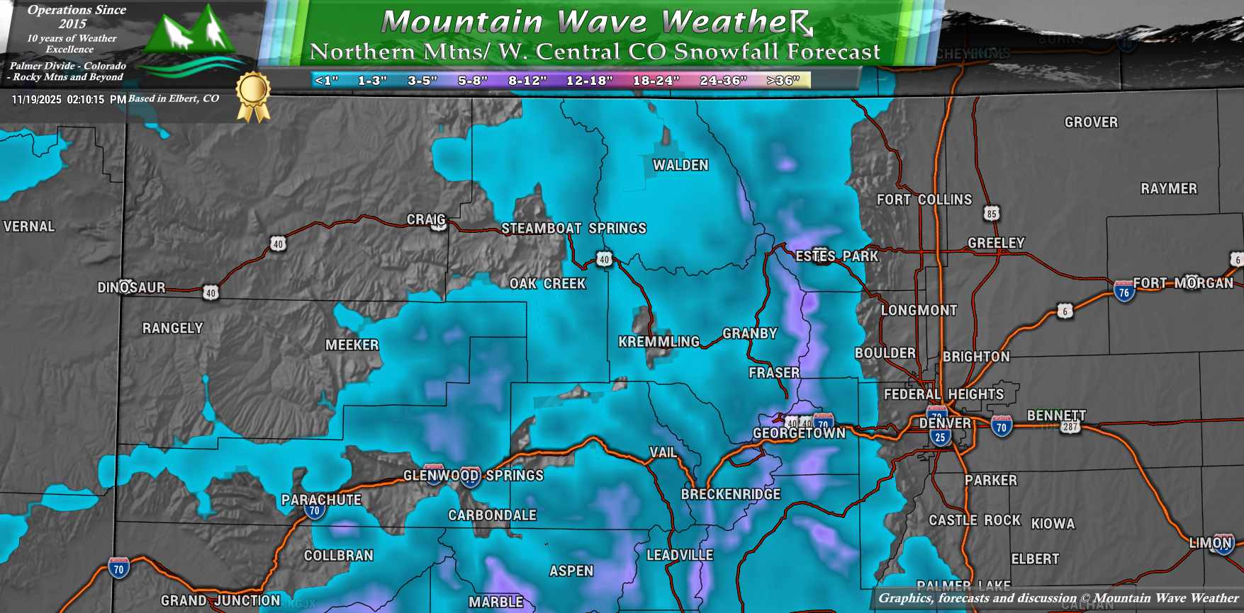
Northwestern CO/ N. Central Mountains
NW and Central Mountains will receive some beneficial snow… they definitely need it with the dry start. That being said, outside of the highest elevation spots along the Continental Divide, this won’t be a ton of snow for those areas.
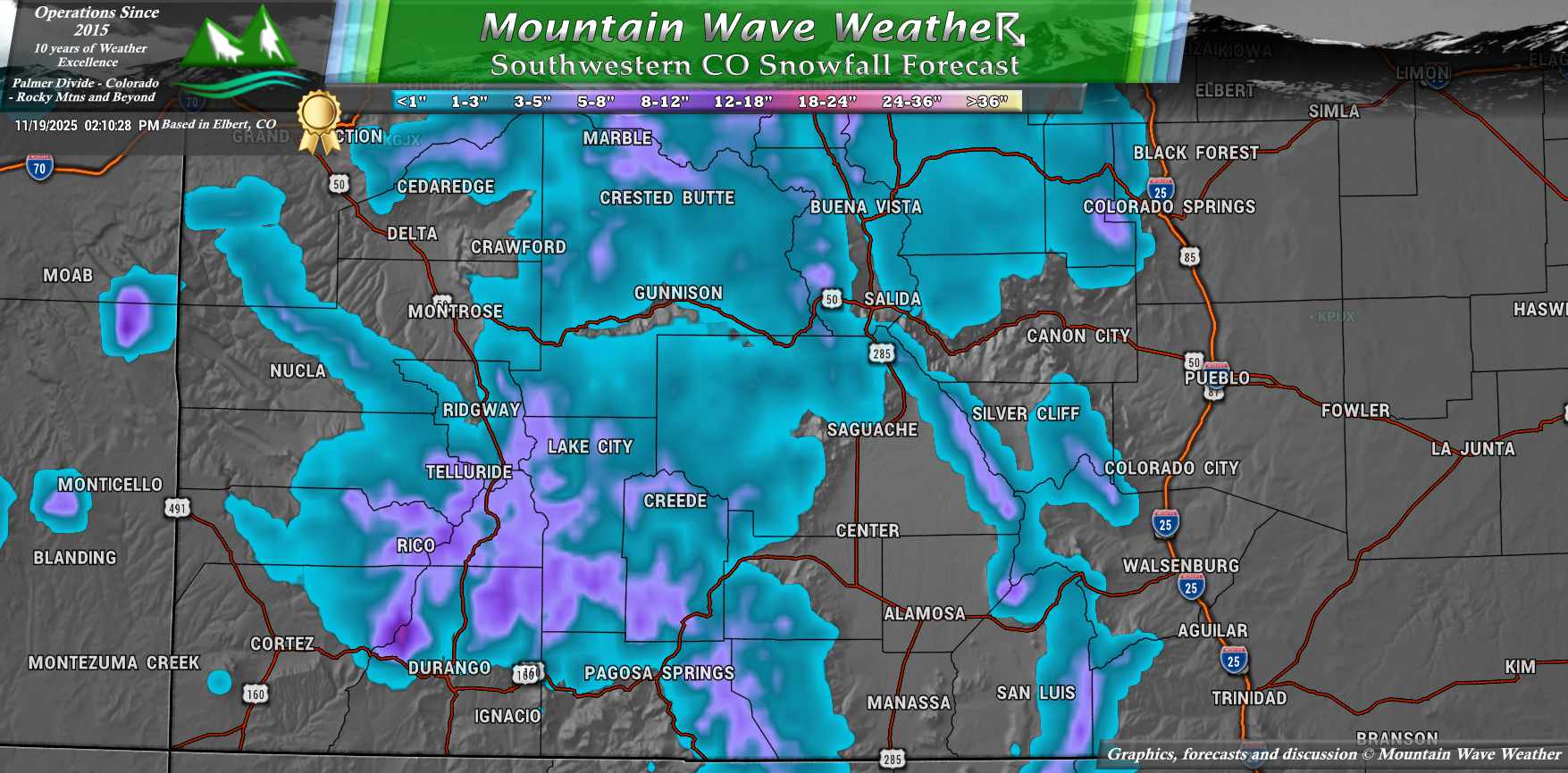
Southwestern Colorado
Due to the track of the storm, some of the favored peaks in the SW corner of the state will be the winners here. Some areas could see up to 1 foot of snow! Expect some travel difficulties as this storm rolls in, a Winter Weather Advisory is in effect for many of these areas with heavier snow expected.
Weather Nerd Synopsis: A Classic Split-Flow Mess
Low confidence, marginal snow potential, but some solid moisture for the Plains
The upcoming Thursday–Friday system continues to be a forecasting headache, not because the synoptic setup is overly complex, but because the model guidance still refuses to agree on anything meaningful at the mesoscale.
We’re now on the third or fourth consecutive model cycle showing major spread across global and regional guidance.
There’s been little run-to-run consistency from the Euro, GFS, or even the ensembles. The usual windshield wiper effect is in full swing, especially when it comes to QPF placement and storm track and frankly, none of the “reliable” models have earned much trust on this one yet.
What we do know (or at least, what’s trending):
-
Snow levels will stay elevated.
This is shaping up as a warmer system overall, so while mountain areas may see some accumulation, most lower elevations, including the Palmer Divide and metro Denver, likely stay too warm for meaningful snow.
-
QPF gradients will be sharp.
There’s a growing signal that the best moisture ends up east of the Front Range. Nearly every global model now shows >0.25″ of rainfall across the eastern plains, but there’s a sharp cutoff on the west side. This suggests I-25 could end up right on the gradient, something to watch closely as CAMs come into better focus.
-
CAMs may help, or may just add noise.
We’re just starting to enter the range where high-res guidance like the NAM Nest, HRRR, and ARW become relevant. Sometimes they help pin down mesoscale details, especially with convective or banded setups but in this case, the synoptic inconsistency might just bleed into those, too.
Big Picture Takeaway:
This is a classic case of a split-flow system trying to phase with northern stream energy and not doing it cleanly. There’s still a window where the southern low could track favorably and bring more precip west, but right now the odds favor a more progressive, east-shifted solution. If that holds, we’re talking about light mountain snow, decent plains rainfall, and another busted snow chance for the metro.
We’ll continue watching ensemble trends for more clustering or signal consistency, but at the moment… not buying into anything too snowy for the lower elevations. That said, a moisture event (even rain) in mid-November isn’t something to complain about.
Impact and Preparation Notes For This Storm System
Not expecting major impacts with this storm on the plains.
If you have ag interests or outdoor plans, just plan for cooler temperatures and rain or rain/snow mix depending on your elevation.
Since temperatures will be marginak (too warm) for many areas to see snow, I’m not anticipating any excessive or extreme cold scenarios with this one.
Continue to keep an eye on the forecast for changes.
Want to Know More? Check Out These Related Articles!

About the Author
Meteorologist John Braddock
Position
