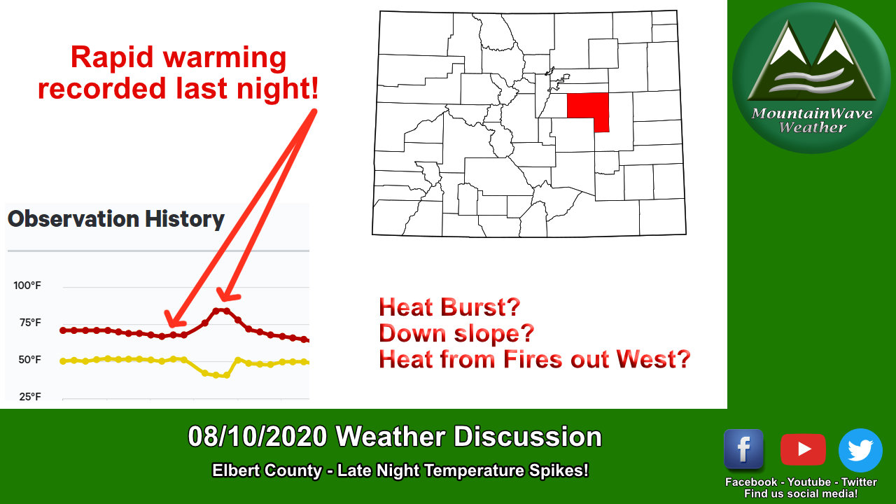
Soaring Temperatures Late Last Night
As I opened my windows last night to try and get the house to cool down from the scorching hot day we had I noticed how incredibly warm it was. Thinking that it might have just been my mind playing tricks on me, I tuned into my weather station to see what was coming in.
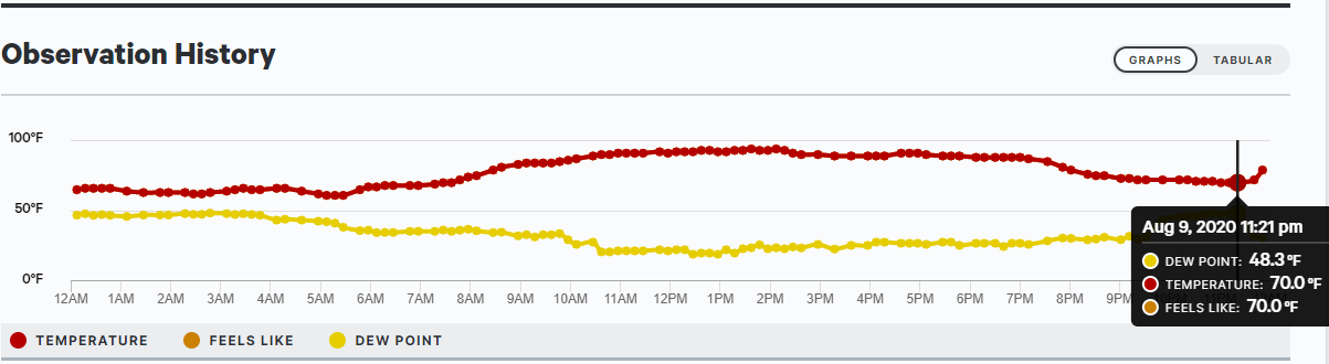
Wouldn't you know it, between 10:30PM and a little after 11:30PM the temperature had risen from 66 degrees to nearly 76 degrees. That's a temperature increase of 10 degrees in about an hour during a time period that is well after dark! While my mind first went to the thought that a "heat burst" had occurred I knew that there are other things that could cause a rise in temperatures like this (down-sloping/shift in winds for example.)
What the Heck is a Heat Burst?
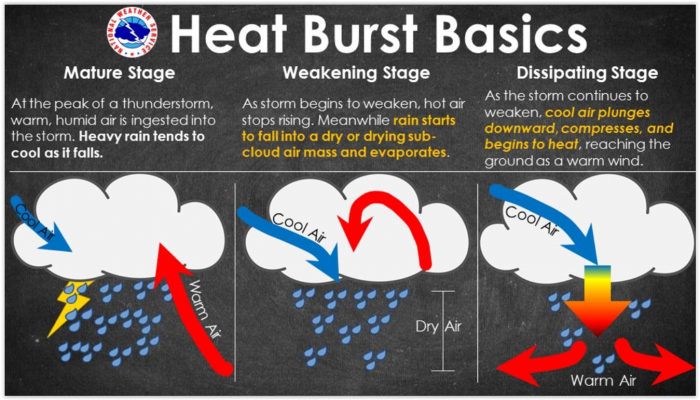
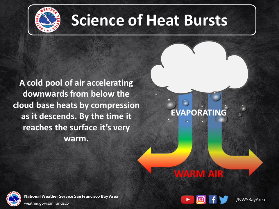
A heat burst is when air from an elevated thunderstorm comes crashing out of the storm, warming as it descends and hits the ground spreading out in all directions. If this sounds like the definition of a microburst then you'd be correct, but in a lot of heat bursts the microburst is dry (no precipitation as the atmosphere below the storm is too dry.) The dry atmosphere is what allows the air to rapidly warm since no more evaporation is occurring as the air falls out of the storm.
Here's a couple of graphics to help illustrate what is going on:
So as often the case in science, now that I had a theory I had to collect evidence to either confirm or deny that theory.
Detective Mode! Find Evidence of Heat Burst
The first thing I had to do is look at other weather stations around the area to make sure this wasn't some one-off or malfunction in my weather station. Here's what I found:
- My station (Elbert, CO): near 10 degree rise in temperature 10:30-11:30PM
- Elizabeth Weather Station: 9 degree rise in temperature 11:00PM - 12:00AM
- Many other personal weather stations in and around Elizabeth reported temperature increases
- Limon Weather Station: 15 degree rise in temperature, later though around 2 AM
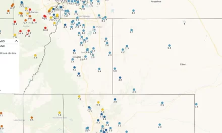
Elizabeth CO temperatures at around 11:20PM

Elizabeth CO temperatures at around midnight
Ok, so several other weather stations registered some sort of temperature increase... the ones closer to me saw this temperature increase around the same time I did. Stations further East towards Limon registered increases later in the evening. We can confirm that the temperature increase was not a fluke reserved to my own weather station.
When we pull up the archived radar data from last night we can see a few interesting features...
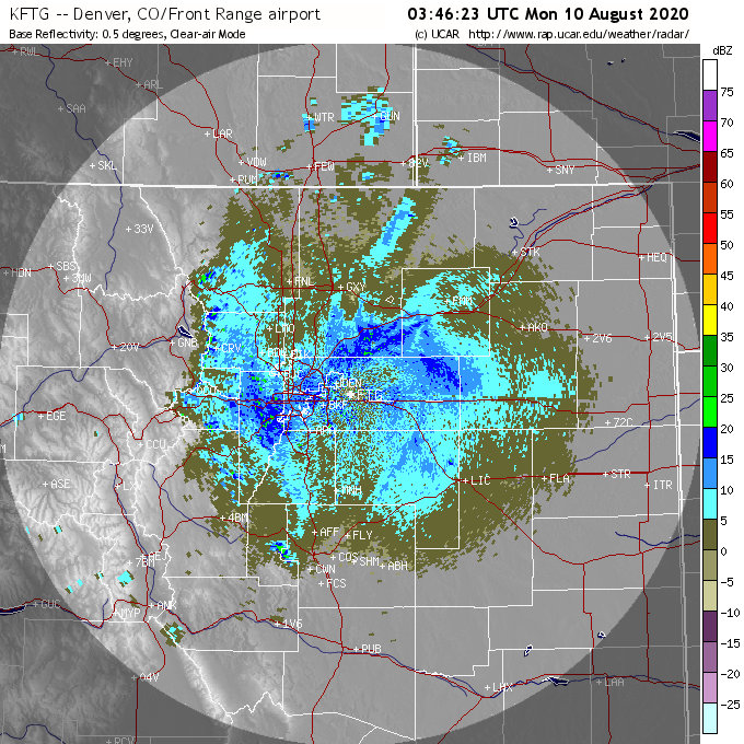
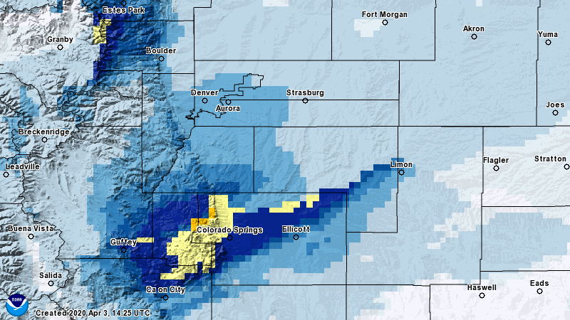
10PM Denver radar
If you look at the radar image above you see a lot of noise which is mainly just junk the radar is returning but there's one interesting feature that catches my eye in Elbert County... do you see it?
Let me highlight it...
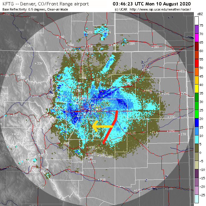
10PM Denver radar
There's a very subtle line that can be seen in Elbert County around 10PM and it's mostly visible in the radar loop with motion as it moves from East to West for about an hour or so. This is an important feature to notice because it looks like either an outflow boundary or a gust front of some kind. Since we don't have much in the way of thunderstorms with precipitation on radar during this time it is likely this strong wind feature is from a collapsing thunderstorm or collapsing elevated storm.
It gives us a few more clues and confirmation to our "heat burst" theory...
A Heat Burst Is Likely When:
- We see a quick increase in temperature of the atmosphere near the surface well after dark - CHECK!
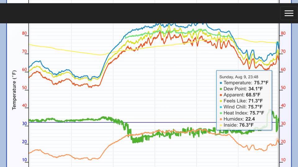
- Notice the red line in the observations on the chart above, many stations recorded a quick increase in temperatures
- There is evidence of strong winds from collapsing storms in the area (outflow boundaries, gust fronts or microbursts - CHECK!
- You can see on the radar snapshots above a line of dust kicked up from an outflow boundary or microburst as it moves Westwards across Elbert County
- We see a rapid drop in dew points with the associated spike in temperatures - CHECK!
- The yellow line in the image above shows a rapid decrease in dew points along with the temperature increase
- The atmosphere is very dry at the surface meaning any storms or microbursts product little if any precipitation at all - CHECK!
- We can verify this by the temperature dew point spreads (70/48 before event 79/30 during event) from the Elizabeth Station but can see similar effects from my weather station
So given the information we see above it's near certain that temperature spikes/ dew point drops were associated with a heat burst event late last night. But there's still one question remaining... why did Limon see their event much later than central and western Elbert County?
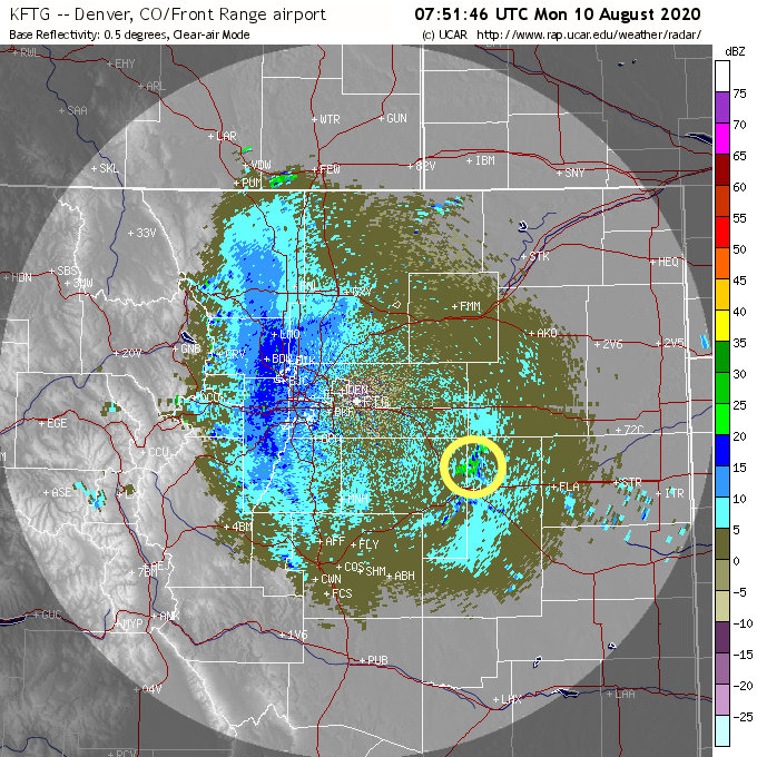
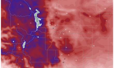
Denver weather radar around 2AM
When you look at the weather radar from last night all the way through this morning you see evidence of collapsing thunderstorms (yellow circle near Limon around 2AM) and several outflow boundary/ microburst events through the evening. So while our heat burst was around the 10:30-11:30PM time-frame in Central and Western Elbert County, it's very likely that areas near Limon experienced their own heat burst in the early morning hours.
In fact I wouldn't be surprised to see many stations report heat burst events throughout the evening and overnight hours based on what I can see happening on radar through the night.
Wrapping It All Up!
Given the evidence this looks like a classic "heat burst" event in my professional opinion. All the ingredients were there (dry atmosphere, temperature spike, dew point drop with recovery, evidence of outflow boundaries/ evidence of dry microbursts on radar, virga, no rain...) that it's very unlikely this was caused by anything else.
It looks like a few other meteorologists in Denver picked up on this event too!
LINCOLN COUNTY, COLORADO -- Limon experienced a dry microburst and associated heat burst during a rain shower overnight! Winds gusts to 67mph and temperatures rocketed 14°, from the low-60s into the 80s after 2am. Wild! Gotta love our Colorado weather. #cowx pic.twitter.com/JPGeZKt17a
— Brooks Garner (@BrooksWeather) August 10, 2020
Heat bursts are not particularly rare around here but you don't see them talked about too often. If memory serves me right based on data from my weather station this is probably the third or fourth heat burst event I've recorded on the Palmer Divide this summer. I'm not so sure it will be our last either given how dry we are and how dry we will look to remain through the rest of the summer and possible fall!

I think I’m very close to you. I live at S. Russellville Rd and 83 and got that wind burst and driving rain as well. Is that the same weather ocurances that they saw in Chicago?