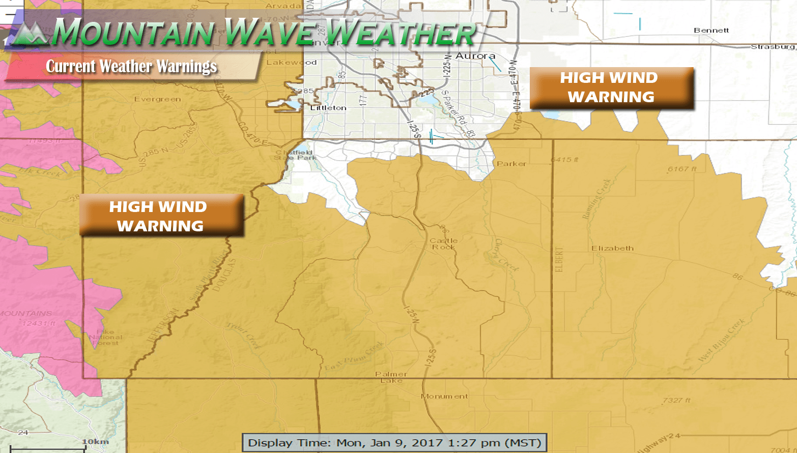
Current Warning Details
INCLUDES THE CITIES OF ESTES PARK, GLENDEVEY, NEDERLAND,
RED FEATHER LAKES, BAILEY, CENTRAL CITY, EVERGREEN, GEORGETOWN,
IDAHO SPRINGS, WESTCREEK, FORT COLLINS, HEREFORD, LOVELAND, NUNN,
ARVADA, BOULDER, GOLDEN, LAKEWOOD, LONGMONT, CASTLE ROCK, ELBERT,
FONDIS, KIOWA, AND LARKSPUR
1148 AM MST MON JAN 9 2017

...HIGH WIND WARNING REMAINS IN EFFECT UNTIL 5 PM MST THIS
AFTERNOON...

* TIMING...STRONGEST WINDS EXPECTED THROUGH MID-AFTERNOON...THEN
  DECREASING SPEEDS LATE IN THE AFTERNOON.

* WINDS/VISIBILITY...SUSTAINED WEST WINDS 30 TO 45 MPH WITH PEAKS
  GUSTS TO AROUND 75 MPH IN AREAS PRONE TO HIGH WINDS. BLOWING SNOW
  IN THE HIGHER FOOTHILLS MAY BRIEFLY REDUCE VISIBILITIES TO NEAR
  ZERO.

* IMPACTS...THE STRONG AND VERY GUSTY CHINOOK WINDS MAY CAUSE
  DAMAGE TO TREES AND POWER LINES AND DISRUPT POWER. WINDS MAY
  ALSO CREATE SLICK ROADS FROM DRIFTING SNOW. DRIVERS OF LIGHTWEIGHT
  AND HIGH PROFILE VEHICLES SHOULD BE ESPECIALLY ALERT FOR STRONG
  AND SUDDEN CROSS WINDS.

PRECAUTIONARY/PREPAREDNESS ACTIONS...

A HIGH WIND WARNING MEANS A HAZARDOUS HIGH WIND EVENT IS EXPECTED
OR OCCURRING. SUSTAINED WIND SPEEDS OF AT LEAST 50 MPH OR GUSTS
OF 75 MPH OR MORE CAN LEAD TO PROPERTY DAMAGE.
What's Going On?!
Today's weather is the result of a strong Mountain Wave established over the front range of Colorado.
We were talking about this yesterday on our Facebook page, so if you follow along with us there, you were probably not caught off guard by this event. The National Weather Service Office in Boulder had some great graphics illustrating what's going on here...
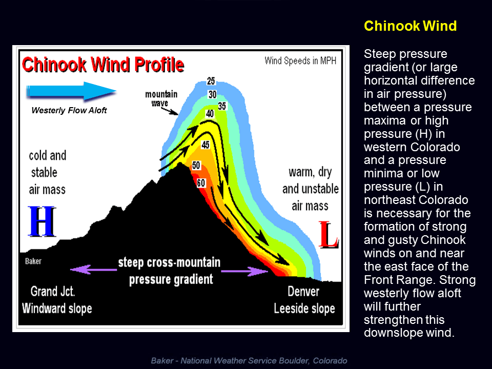
A strong storm system with westerly flow aloft creates as High Pressure West of the mountains. Airflow naturally wants to move from a high pressure area to a low pressure area so we see strong winds establish over the mountains and along the front range. A low pressure system at the surface (often called a lee-side low) can help enhance this effect.
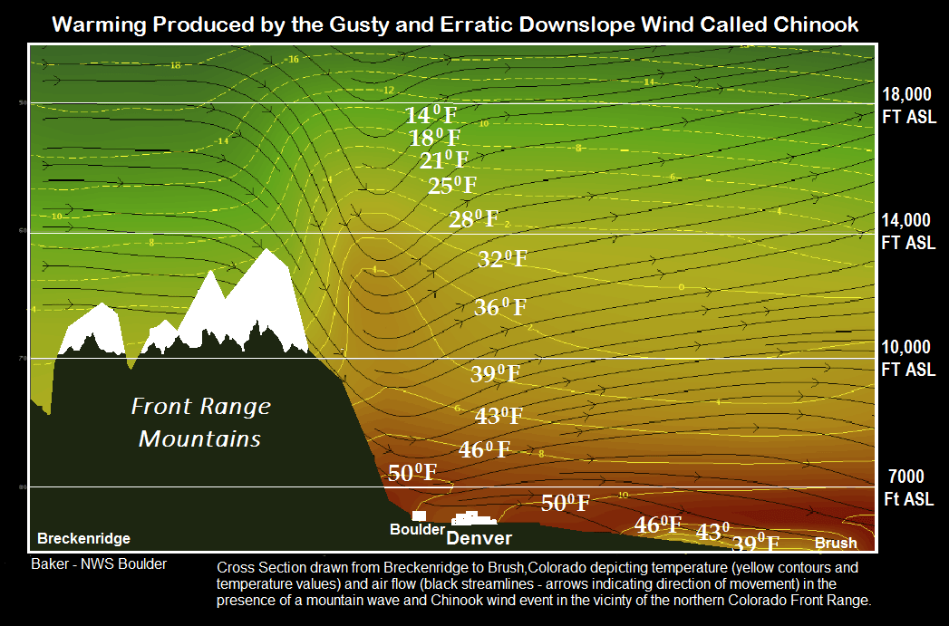
As the air moves over the mountains it begins to race down the front range and foothills, picking up speed as it does so. Any cities caught under the strong winds will see the situation we are having today. In addition, as the air travels down in elevation it warms, another reason we are seeing unseasonably warm temperatures in the area today.
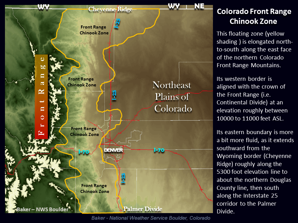
You'll notice the areas that see the worst out of these events are what is known as the Front Range Chinook Zone. These areas are more prone to strong winds during these events due to their terrain and their close proximity to the foothills and mountains.
This is often called a Chinook Wind Event or Mountain Wave (yes the same Mountain Wave we have named this site after.)
When Does It End?
Luckily in this case the winds look to subside a bit this evening. The bad news is that if modeling trends hold correct we can expect to see windy days on Tuesday and Wednesday as well, but it doesn't look to be as strong as on Monday.
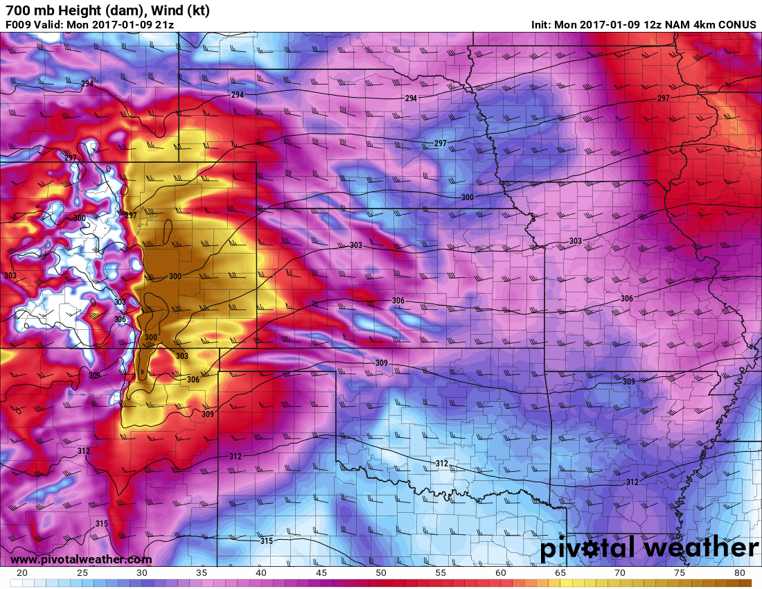
Here's a model snapshot of low-mid level winds for today at 2pm, notice the strong winds coming over the foothills and affecting the front range
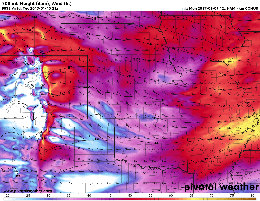
The next is a snapshot of expected low-mid level surface winds for Tuesday around 2pm. Notice the winds are a bit lighter on Tuesday but still relatively strong. I'd expect some gusts to still cause damage and give trucks problems traveling along interstate 25.
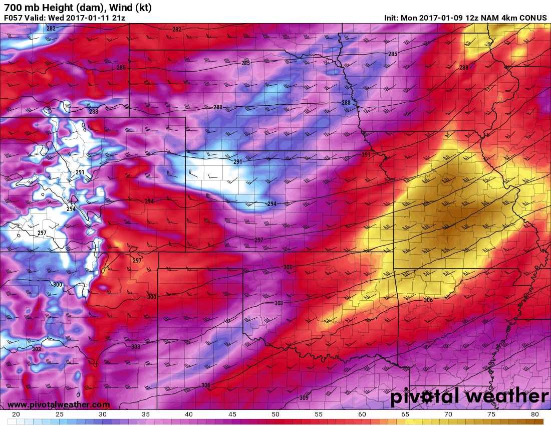
By Wednesday we see a further lightening of the winds, but still expect some gusts here and there.
Main Takeway
The main point here is expect strong damaging winds on Monday through the 5-6pm hour. After that we expect lighter breezes over night but Tuesday will see a return to windy conditions as the Mountain Wave re-develops over the front range.
If you haven't secured anything (or it's blown away today) be prepared for similar conditions on Tuesday! Also, check those fences, I've noticed a lot of damage to residential fences around town today!
