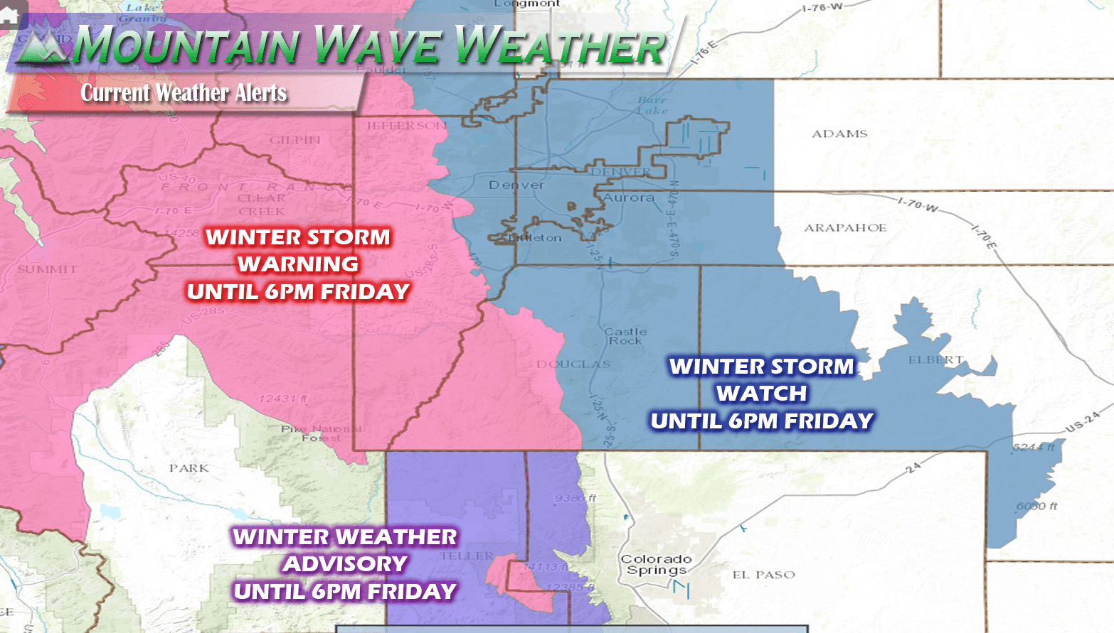
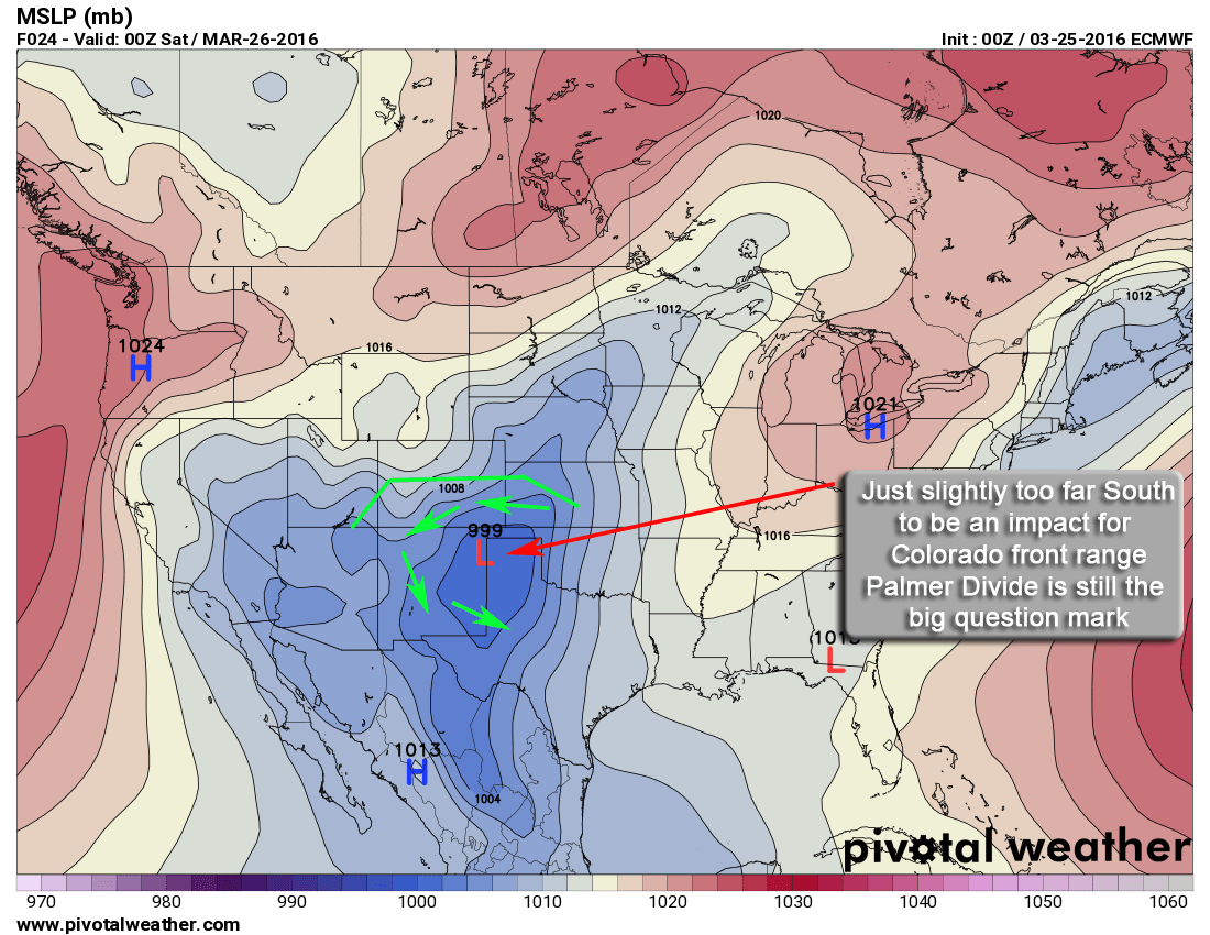
A quite powerful storm with a ton of moisture. Big question is, how much is snow and how much it will accumulate based on temperatures?
Storm forecast looks pretty well on track so far this evening. Here's a few quick bullet points regarding timing of the worst and some steps that should be take to prepare for this storm.
- Plants and sprinkler systems should be fine Wednesday night. Freezing temps not expected and areas that do see them in and around Castle Rock won't see a long enough period of time to do damage.
- Expect some snow and rain early on Thursday. Not expecting major impacts early in the day Thursday. That being said, if you have outdoor plans Thursday and Friday are going to be cold, wet and pretty miserable. Keep that in mind and dress appropriately!
- Heaviest snow later in the day Thursday and into Friday morning and Friday afternoon. The Thursday evening commute COULD be impacted if things move quicker and the air trends colder.
- Plants and and above ground sprinkler systems should be covered for Thursday and Friday night. I'd recommend draining the above ground sprinkler equipment, low temps for Castle Rock are projected at about 28 on Thursday night and 24 on Friday night. This qualifies as a Hard Freeze on Friday night!
Don't Be Caught Unaware
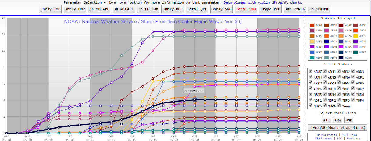
A look at the SREF NCEP ensembles with a mean of 4.04in. I see this as more realistic but interesting to note it has jumped up nearly 2 inches for the main throughout the day Wednesday!
Just because I'm not super excited about the snowfall out of this storm, don't take that as a sign nothing will happen. This storm still has POTENTIAL to drop significant snowfall, even though the probabilities for that are low, they are still not anywhere near 0%!
This storm system is early in it's forecast cycle and there still remains considerable uncertainty so we will be keeping a close eye on a few factors tomorrow that could drastically change the forecast such as:
- Models all trended significantly higher with snowfall and lower with temperatures with tonight's data. This may impact who sees how much snow and drop the snow line a bit.
- Not going to post those one-off models tonight. Frankly they nearly made me fall out of my chair and I'll consider them model flip-flopping until I see more of them trend that way. Nevertheless, it's something to keep an eye on tomorrow!
- Extreme severe weather is expected in portions of Kansas, Oklahoma and Texas. We've seen situations like this before where those storms can act like sponges and mop up a lot of the moisture before it makes it's way to Colorado.
- You may or may not recall, this same exact thing happened with a storm system last year in April. Huge amounts of snow expected, all moisture got robbed from Colorado by severe storms out East of the state.
So in short, a lot to keep an eye on in the next 12-18 hours. Stay tuned for any forecast updates tomorrow!
