A quick hitting cold front and associated moisture is expected to move through the metro area this afternoon. Many models have snow moving across the mountains and onto the plains around the 12-1PM time-frame with snow filling into Denver and the South after about 2-3PM.
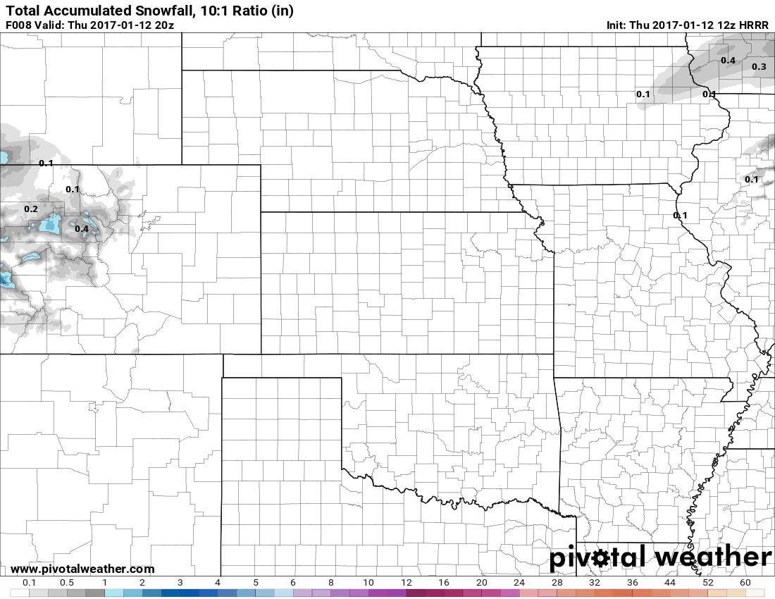
Latest HRRR snowfall model for today
The latest models are a bit off with how much snow actually falls but they all agree areas immediately West and Northwest of Denver will see the biggest impact (think Boulder, Morrison, Golden areas, etc..) Let's be clear though, this will not be a long duration event. This storm will move through quickly and exit quickly, meaning it won't linger long enough to ruin tomorrow or the weekend.
That being said, some models show a pretty decent shot of snow for some areas while it's here. These types of storms are known for dropping an inch to a couple of inches in a very short period of time. While this means we won't see a ton of snow out of this, the impacts on the roadways could be notable as this storm is set to impact the metro area around the evening commute.
Latest Forecast Update
This quick hitting storm won't bring a ton of snow to most areas along the front range but we can't ignore the fact that its impact will be felt during the evening commute. With the cooler temperatures and short but intense bursts of snow, we know that it doesn't take much to make the roadways slick.
Timing
- The storm is projected to move into the area around 12-1PM, mainly affecting the Western areas of Denver and foothills at first.
- As we move into the 2-3 or 4PM hours, we expect snow to fill in across the metro area. Castle Rock may see some snow out of this but I expect the biggest impacts will be North of town.
- The quick bursts of snow may impact your commute if you are traveling down from Denver or in from the West.
Snowfall
- Areas in and around Denver are expected to see 1-3 inches.
- Foothills locations and areas West and Northwest of Denver could see 2-4 inches out of this storm.
- There is a sharp dividing line North/South from the Tech Center of Denver. Castle Rock is currently only modeled to see 0-1 inches out of this storm. I'd suspect up to 2 inches is possible but anything over that is very unlikely.
-
Impacts
- Expect roads to become slick in areas where intense bursts of snow set up
- This isn't a long duration event, roads may get slick overnight but snow is not expected to last too late into Thursday night.
Summary
This storm looks like it will be more of an inconvenience this evening than a big problem for most tonight. Current modeling has most of the heavier snow staying North of the Castle Rock area so we don't expect major travel problems in the area overnight. Some areas will see a decent bit of snow, mainly North and West of Denver.
We will keep a close eye on this in case the forecast changes, as you'll recall any shift can mean more or less snow for our area. Stay tuned!
