Watches/Warnings/Advisories for the Palmer Divide
A pretty significant storm is shaping up along the front range and Northeastern Colorado. A high impact "spring blizzard" type storm will move into the area Wednesday and bring with it heavy snow, strong winds and dangerous travel conditions. Here's the latest:
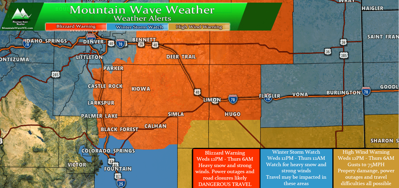
Current watches/warnings/advisories for the Palmer Divide region as of 5PM 3/11/2019
Blizzard Warning
...BLIZZARD WARNING IN EFFECT FROM NOON WEDNESDAY TO 6 AM MDT
THURSDAY...

Including the cities of Castle Rock, Elbert, Fondis, Kiowa, Larkspur, Briggsdale, Grover,
Pawnee Buttes, Raymer, Stoneham, Brush, Fort Morgan, Goodrich, Wiggins, Bennett, Byers,
Deer Trail, Leader, Agate, Hugo, Limon, Matheson, Crook, Merino, Sterling, Peetz, Akron,
Cope, Last Chance, Otis, Julesburg, Ovid, Sedgwick, Amherst, Haxtun, and Holyoke

* WHAT...Blizzard conditions expected. Total snow accumulations
  of 6 to 12 inches expected. Winds gusting as high as 65 mph.

* WHERE...Portions of east central and northeast Colorado.

* WHEN...From noon Wednesday to 6 AM MDT Thursday.

* ADDITIONAL DETAILS...Travel could be very difficult or
  impossible. Avoid travel Wednesday afternoon and Wednesday
  night. Widespread blowing snow will significantly reduce
  visibility. Very strong winds could cause extensive tree damage
  and result in scattered to widespread power outages.

PRECAUTIONARY/PREPAREDNESS ACTIONS...

A Blizzard Warning means severe winter weather conditions are
expected or occurring. Falling and blowing snow with strong winds
and poor visibilities are likely. This will lead to whiteout
conditions, making travel extremely dangerous. Do not travel. If
you must travel, have a winter survival kit with you. If you get
stranded, stay with your vehicle.
Winter Storm Watch
...WINTER STORM WATCH IN EFFECT FROM WEDNESDAY AFTERNOON THROUGH
WEDNESDAY EVENING...

The Southern Front Range Foothills-
Boulder and the western suburbs of Denver-
Including the cities of Bailey, Central City, Evergreen,
Georgetown, Idaho Springs, Westcreek, Arvada, Boulder, Golden,
Lakewood, and Longmont

* WHAT...Heavy snow possible. Total snow accumulations of 4 to 8
  inches possible. Winds could gust as high as 45 mph.

* WHERE...The Southern Front Range Foothills and Boulder and the
  western suburbs of Denver.

* WHEN...From Wednesday afternoon through Wednesday evening.

* ADDITIONAL DETAILS...Plan on slippery road conditions. Patchy
  blowing snow could significantly reduce visibility. The
  hazardous conditions could impact the afternoon and evening
  commute with rapidly deteriorating conditions by midday
  Wednesday.
 PRECAUTIONARY/PREPAREDNESS ACTIONS...

A Winter Storm Watch means there is potential for significant
snow, sleet or ice accumulations that may impact travel. Continue
to monitor the latest forecasts.
***Potentially High Impact Storm!***
Our Forecast (As of this post) and What To Expect
Expected Snowfall (through Thursday 12PM) *Preliminary, keep checking back for changes!*
*These are our forecast numbers and may not always match the NWS official forecast numbers*
- Castle Rock and surrounding areas
- 5-10 inches
- Parker, Lone Tree, Highlands Ranch areas
- 4-9 inches (concerns about lower snow amounts among lower elevations due to warm air)
- Elbert, Elizabeth, Kiowa
- 6-12 inches
- Larkspur, Monument
- 6-12 inches
- Woodland Park, Palmer Lake, W. Colorado Springs Foothills
- 6-12 inches
Timing
- The storm moves into the area Wednesday morning, precipitation may start out initially as rain depending on elevation
- By noon on Wednesday the Blizzard Warning goes into effect. As we move into the afternoon hours snow and wind will pick up and road conditions will deteriorate
- Highest impacts for travel look to be 12PM Wednesday through 6AM Thursday
- Plan on impacted travel (roads and the airport) If you have flights at DIA pay close attention to cancellations
Potential Impacts
- Areas within and immediately surrounding the Blizzard Warning area can expect the potential for road closures, power outages and property damage due to wind.
- Ranchers and ag interests should take actions to prepare livestock and property from serious impact
- This has the potential to be a high impact storm. Travel is not recommended later in the day Wednesday and into Thursday morning
Synopsis
As of Monday afternoon, everything still looks on track with this storm. We are cautiously optimistic that this one delivers a pretty good wallop to the Palmer Divide and NE Colorado. That being said, we will have to watch very closely in case this thing shifts or falls apart at the last minute. That's something we will be keeping a close eye on through the day on Tuesday.
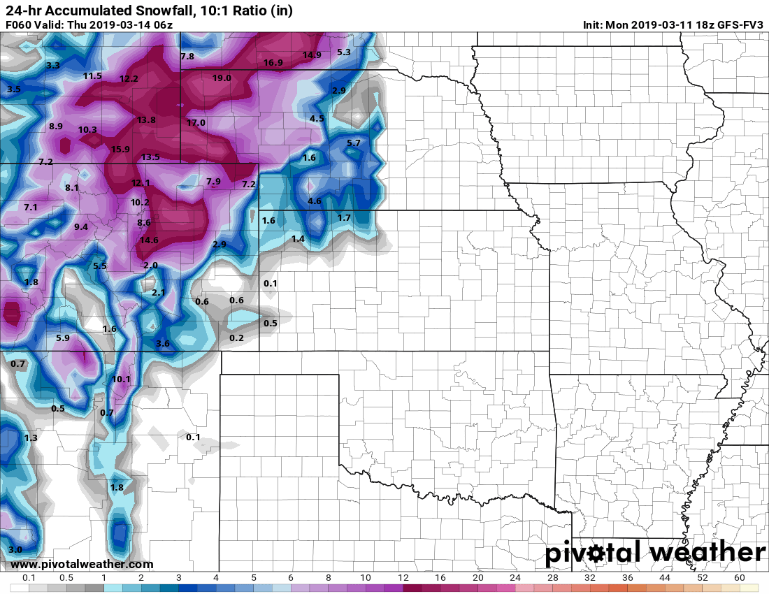
Here's some models:

GFS 24 hour snowfall accumulation as of 6AM Thursday
The GFS has been bouncing around on this storm, anywhere from super excited to not expecting much at all. Since this tends to over and under react to a lot of short term changes, it's something we watch for patterns and shifts but don't put a ton of stock in just this one model.
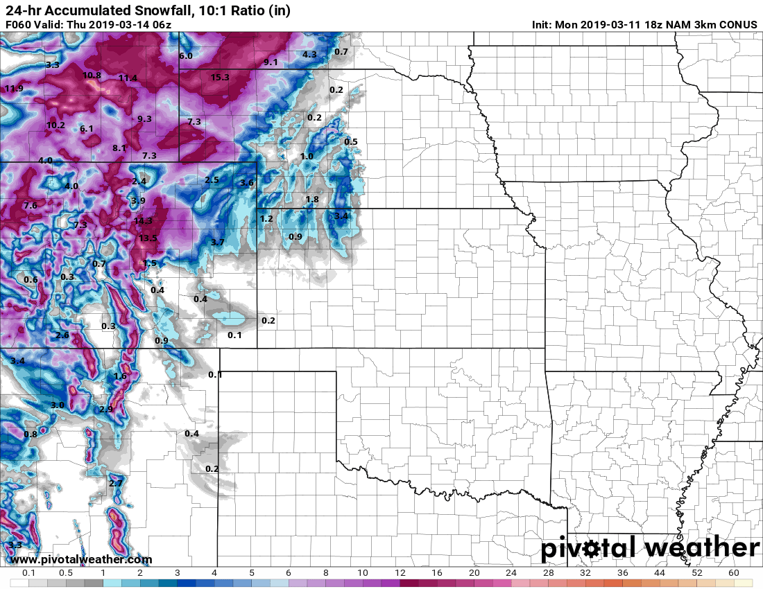
GFS FV3 is a newer upgrade of the GFS model launched recently. It's still in a testing phase but still fun to keep an eye on
NOAA's newer upgraded GFS FV3 (stands for Finite Volume Cubed-Sphere dynamical core in case you wanted to know) is something we like to keep an eye on. It's still in a bit of a testing phase so I haven't been able to yet determine its accuracy vs the standard GFS or any of the Nam/Euro models. It's still fun to look at... it's a lot more excited about this storm than its older cousin.
NAM3K 24 hour snowfall accumulation
Nam3K is more excited about this storm as well. I love when the higher resolution comes into range as we can start to see some of the subtleties around where this model thinks the bigger snow will be.
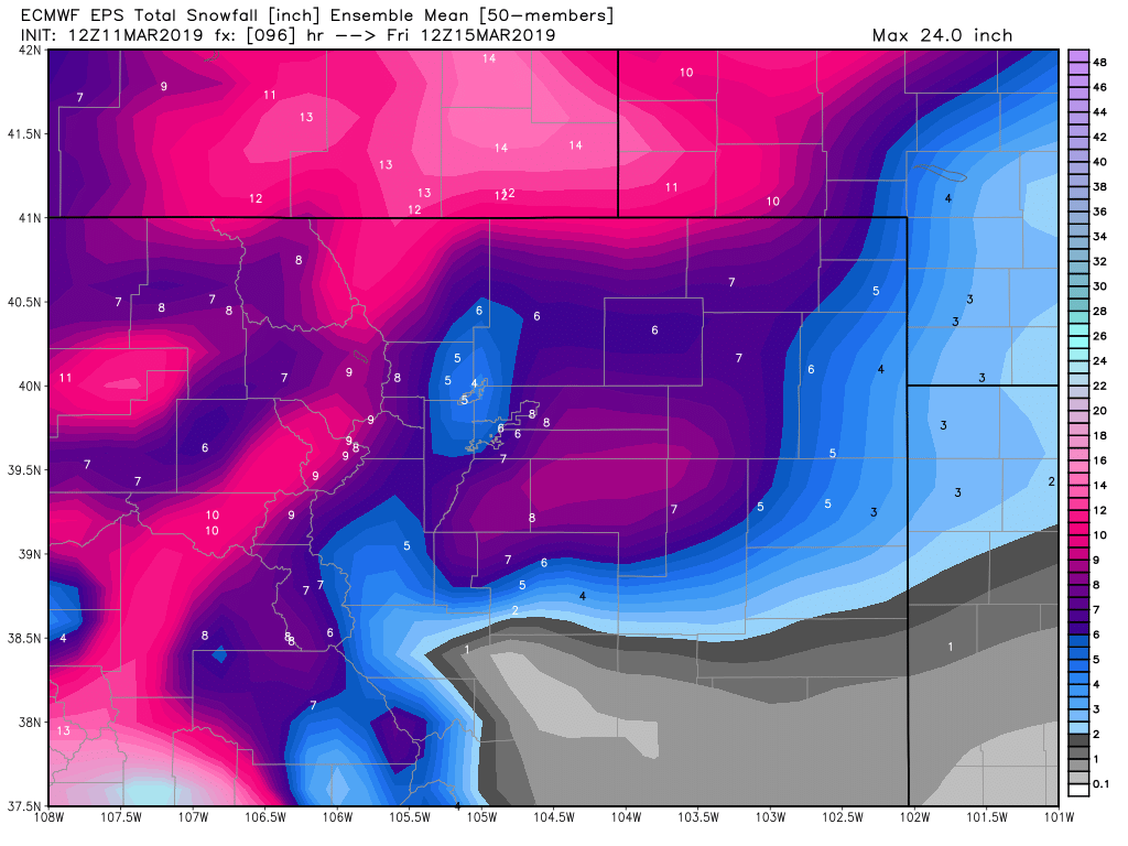
Euro models expected snowfall
Finally the EURO, also pretty excited about this storm and one to always watch as it tends to be more accurate than the others. The main drawback is that it only updates a couple of times a day so it can miss short term changes.
A Historic Storm?
In a sense, if things set up this could be one for the record books. Some of the models are showing incredibly low pressure in the center of this storm system. In fact, what we see in the pressure with this storm is similar to the pressures we see in moderately strong hurricanes. This is why we are pretty confidence in a high wind event at the very least.
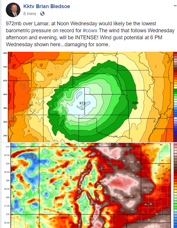
Like I've mentioned the past few days, hopefully everyone has taken this seriously and made preparations. I'm most concerned about people just East of Castle Rock into Elbert County and points East and Northeast.
Is there still potential that this storm does absolutely nothing? Yes, but it's looking less and less likely. Still we will be watching closely because these big spring storms are often in the habit of throwing curveballs that could potentially upend our forecast completely.
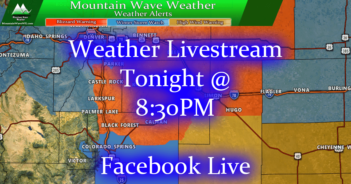
Tune in tonight for a Facebook Live Stream discussing this storm!
One last thing, I'll be doing a livestream tonight looking at some of this information and discussing it. I will also have some updated data to look at and general storm discussion. Don't miss it!
Facebook Page for the Livestream


yikes!