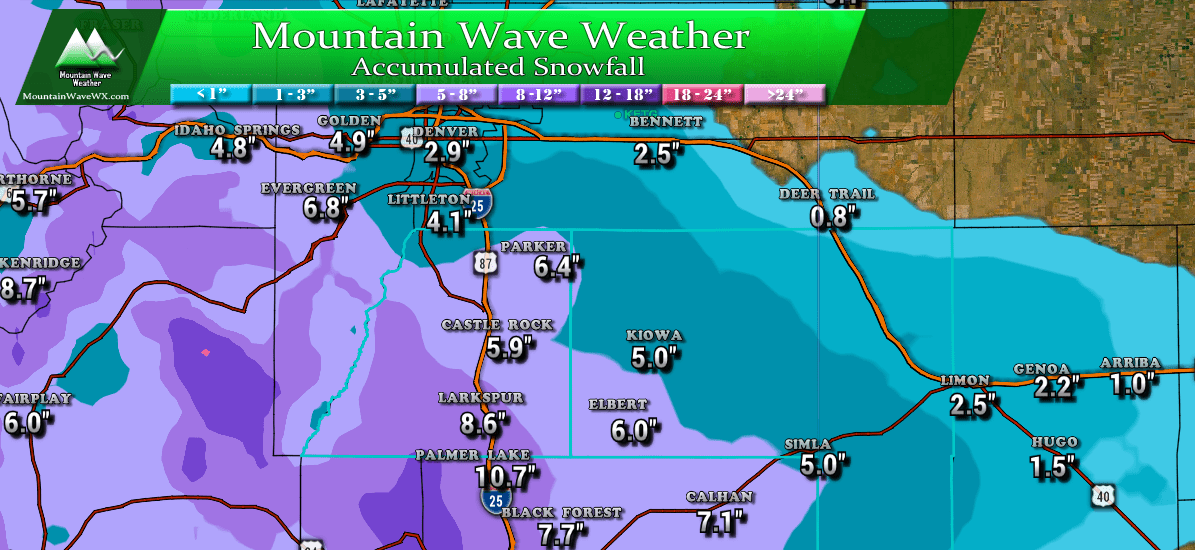
Total snowfall accumulation through Wednesday PM 10-31-2018
Expected Snowfall totals for Areas Around the Palmer Divide
Here's our latest thinking on overall snowfall for areas along the Palmer Divide. Our forecast is largely in line with the NWS forecast, but lower than some of the TV stations have been predicting around here. I still think the ground being so warm will play a part in melting some of the initial snowfall and suppressing snow totals just a bit.
-Castle Rock: 4-8 inches
-Parker: 4-8 inches
-Lone Tree: 3-6 inches
-Kiowa/Elizabeth: 3-6 inches
-Elbert 4-8 inches
-Larkspur: 5-10 inches
-Palmer Lake: 6-12 inches
-Black Forest: 5-10 inches
-Monument: 6-12 inches
-Woodland Park: 7-14 inches
Updated Impacts/Advisories
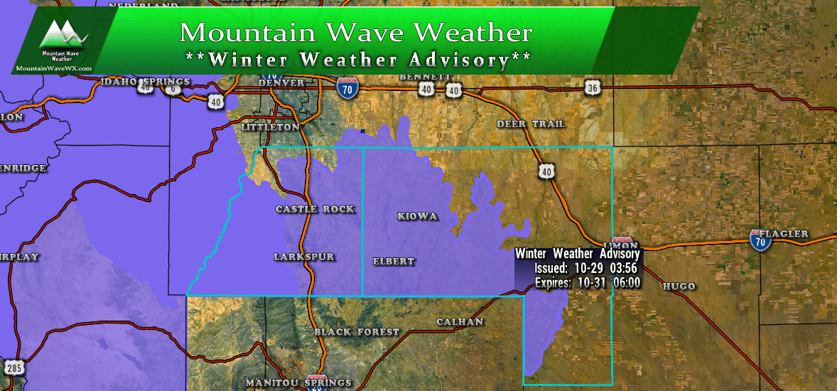
A Winter Weather Advisory is in effect from Tuesday 12PM through Wednesday 6AM for travel impacts due to snow
Plan on slippery road conditions. The
hazardous conditions could impact the evening commute Tuesday
and the commute Wednesday morning.
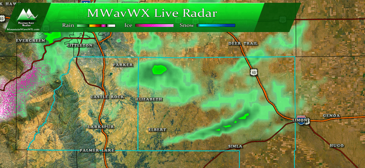
Look at the first bit of precipitation moving through as of 10:30 AM this morning
- Impacts
- Expect tricky travel conditions Tuesday evening, overnight Tuesday and Wednesday mornings
- Roads will become snow-packed and icy in areas
- Colder air will be in place Tuesday and Wednesday so be prepared for chilly conditions
- Timing
- Scattered snow showers will be possible earlier in the day Tuesday
- Expect more substantial snow showers to develop later in the Tuesday, through the evening and overnight hours
- Snow showers will linger through Wednesday morning
- Snow should clear by mid-day Wednesday
- Clearing conditions will continue through the day into the evening Wednesday but cold conditions will remain
Halloween Temperatures
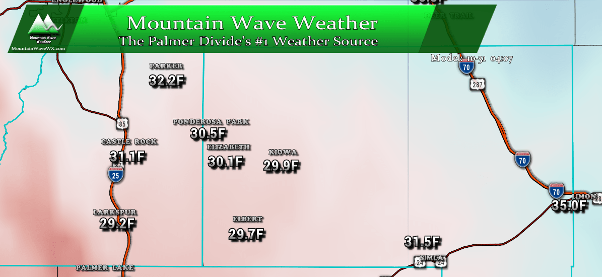
Temperatures on Halloween 2018 ~ 4PM
Halloween is going to be chilly, if you have trick-or-treaters going out, be sure to dress warm and watch for remaining ice on the roads and sidewalks. The model above has temperatures generally in the low 30's to upper 20's across most of the Palmer Divide around 4PM.
We'll continue to keep an eye on it and pass along any storm updates as needed on Tuesday. Stay warm!
